 |
Home | Search | Browse | About IPO | Staff | Links |
|
Home | Search | Browse | About IPO | Staff | Links |
|
A monumental joint effort shapes up to revitalize one of The Illinois And Michigan Canal National Heritage Corridor By Richard K. Quateman
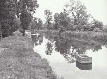
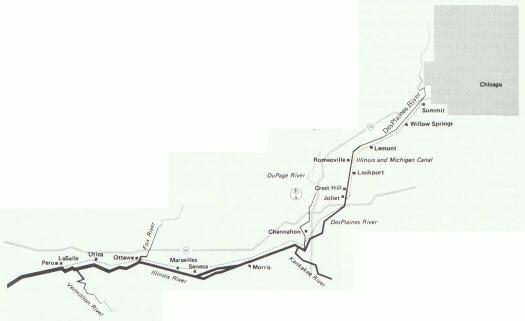
In the next few months Congress will be considering a new management category within the National Park Service: the National Heritage Corridor. The first area to receive this designation is in Illinois along the historic Illinois and Michigan Canal from Chicago to LaSalle/Peru. A National Heritage Corridor is a cooperative land management program in which the existing local, state, and Federal land managers voluntarily coordinate their independent holdings around a central interpretive theme. Unlike most other Federal categories the land ownership is not transferred to a single authority. In addition, the voluntary participation of private landowners is not only encouraged, but is central to the success of the program. The Illinois and Michigan Canal National Heritage Corridor will transform an existing framework of eight state parks, numerous forest preserves and local parks, and hundreds of historic and archeological sites into a system whose central purpose is to interpret a total landscape: the ecosystems, archeology, history, and cultures of the Illinois and Des Plaines river valleys and the Illinois and Michigan Canal.
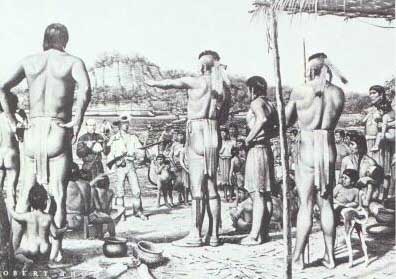
The National Heritage Corridor will improve and expand the recreational opportunities of this 100 mile-long valley and increase public awareness of these resources. It is designed to stimulate an economic revitalization through downtown renovations, improved educational and recreational amenities, and a quality of life conducive to industrial retention. The Illinois and Michigan Canal first was suggested by Jolliet during the Jolliet-Marquette explorations of the Des Plaines and Illinois rivers in 1673. He observed that this vast prairie land was used as the portage route between Lake Michigan and the Mississippi River. The valley was the "gateway to the west" and as exploration and settlement increased, the corridor was heavily trafficked by fur traders and early pioneers. The potential benefits of a canal through the valley were also recognized when the boundaries of the new state of Illinois were laid out. The northern border of the state was shifted to give Illinois a Lake Michigan shoreline, the current ten northernmost counties, and the site of the city of Chicago. In 1836 the canal first envisioned by Marquette and Jolliet and promoted by then state representative Abraham Lincoln was begun. Twelve years later an efficient and affordable means of transportation linking the Great Lakes to the Mississippi was completed. Irish canal workers, as well as immigrants from other parts of Europe settled in the area and canal towns soon replaced the temporary construction camps. The mouth of the Chicago River was considered the beginning of the route of the I & M Canal, and the Canal Commissioners had the responsibility of surveying and platting not only towns such as Ottawa and Lockport but Chicago as well. Soon after completion of the canal Illinois Parks and Recreation 10 November/December 1982
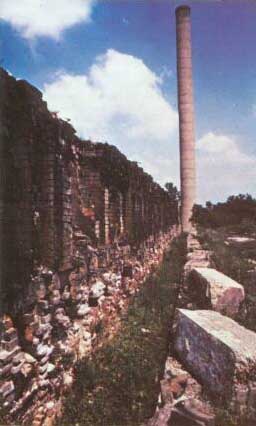
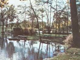
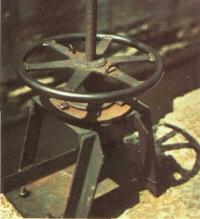
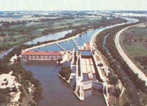
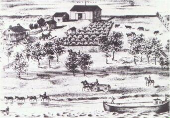
Illinois Parks and Recreation 11 November/December 1982 the railroad was brought through the region, approximately and closely parallel with the I & M. As the demand for the manufactured goods of the east and the agricultural products of the west increased, the towns grew and a number of industries, including stone quarrying, mills, and foundries were established along the route. The corridor became the center of the industrial revolution in the upper midwest. As development continued, Chicago required a means to transport its wastewater away from the city and in 1892 a new canal, the Chicago Sanitary and Ship Canal was begun. Use of the Illinois and Michigan Canal ended soon after. Much of the past history of the region survives, however, in the canal towns and early industrial sites. Thirty-seven natural areas preserve examples of the original valley environment. Industry, too, is a major presence in the valley and some of America's largest corporations operate facilities along the canals. The value of the Illinos and Michigan Canal and environs as a source of both recreation and educational/interpretive activities has been known for many years. As early as the 1930's the Civilian Conservation Corps was active in the area, restoring portions of the canal and towpath and establishing trails and picnic areas. Over the years, however, many of these improvements have deteriorated. The state of Illinois, too, is aware of the canal and from Lock #5, just south of Joliet, down to LaSalle, the canal and towpath have been designated as the Illinois & Michigan Canal State Park. In the corridor as a whole there are some 4,200 acres of natural areas in various public holdings, including Palos Forest Preserve (the largest in Illinois) and Starved Rock State Park. Another 2,000 acres are in. mixed public/private ownership. The national significance of the archeological, historic, cultural, and natural resources of the corridor of the I & M Canal was established in a 1980 National Park Service Reconnaissance Study. Several citizens' groups have also been extremely active in exploring the opportunities of the valley. Some of their most notable achievements have been the restoration of the Reddick Mansion in Ottawa, Bicentennial Park in Joliet, the interpretive activities of the Will County Historical Society, and the fight by Save the Valley to prevent quarrying in the corridor. What has been lacking in the efforts of all persons and agencies, however, has been coordination and a lack of public knowledge of the extent of the corridor's resources. Many actions have been taken, but with few exceptions efforts have been either frustrated or of short-term benefit. As in the case of the Civilian Conservation Corps restorations, there has been no infrastructure to support long term maintenance and focus. Neither the recreational or interpretive facilities are as maintained or developed as might be. In 1979, Open Lands Project, a Chicago based non-profit corporation working to promote public open land in Illinois, undertook a detailed study of the area from Joliet to Summit. An area of heavy industrialization, it was considered by most people to be too developed to be of any potential value for public use. But, to the contrary, the area turned out to be one of great diversity and hidden beauty. The area is heavily industrialized, as are other portions of the corridor but these industrial sites have potential for interpretation. Just as the natural areas and native American archeological sites are part of the landscape, so are the industries. Open Lands Project saw that there was great potential for the region if efforts were coordinated. U.S. Senator Charles Percy and Representative Tom Corcoran had been interested in a program in the corridor for many years and caused the National Park Service to conduct a study of the resources of the corridor and produce a concept plan to ". . . protect and enhance the abundant cultural and natural resources of the I & M Canal while at the same time providing for economic development." (N.P.S., 1980, p. 1). One hundred local citizens were
Illinois Parks and Recreation 12 November/December 1982
involved in the production of the concept plan, and an additional 150 people were involved in the review process. The 100 people, having a broad diversity of expertise and concerns were divided into six work groups. The categories were: recreation, conservation, historic and cultural, water quality, land use and interpretation, and economic development. Over a nine month period the resources of the corridor were determined, goals, objectives, and benefits outlined, and concerns studied and dealt with. A number of implementation strategies were also developed. Economic development for the region is not an afterthought; it is integral to the plan. Like many other parts of the country the region is suffering from severe unemployment and a lack of a positive self image. It is one of the purposes of the National Heritage Corridor to improve the economic vitality of the region. As laid out in the National Park Service concept plan and the legislation introduced in Congress, the objectives of the Illinois and Michigan Canal National Heritage Corridor are: stabilization of the structure of the I & M Canal and renovation of portions for interpretation; establishment of a network of trails on both land and water from Summit to Peru; protection of the natural setting of the canal and the unique natural areas of the corridor; enhancement of public awareness and appreciation of the archeological resources; restoration of historic buildings with economic development potential; interpretation of the cultural and natural resources of the corridor; and enhancement of economic development in the corridor.
There will be many physical changes within the corridor. The existing trail from Lock #5 in Joliet to La Salle (the Illinois & Michigan Canal State Park) will be expanded and improved. A canoe waterway from the portage point in Summit to Cache Island in Romeoville is being considered by the Forest Preserve Districts of Cook, DuPage, and Will Counties. Cache Island now is owned in part by Will County which is negotiating for acquisition of the remainder. The Lockport Township Park District plans to develop its section of the canal as a cultural park. A footpath along the Commonwealth Edison right-of-way from Hodgkins to Lockport is also being considered. Implementation of the path will be subject, of course, to the agreement of Commonwealth Edison and the adjacent landowners. Concerns over liability exposure are being addressed by the state of Illinois. Renovation of historic buildings throughout the corridor is another focus of the program. Many of the canal towns contain buildings of historic significance and the central business district of the Village of Lock-port is a National Register Historic District. As part of the development program, tax incentives and innovative financing schemes to facilitate private sector involvement will be explored. It is hoped that currently used buildings will be restored to their former elegance and that those no longer being used will be converted for both commercial and interpretive purposes. Like other activities in the corridor, historic restorations and adaptations will be managed as a cooperative venture of both the public and private sectors. Natural areas interpretive programs in the corridor will be expanded as will archeological and historic sites interpretation. Many of these areas are privately owned and negotiations for public access are already underway. One such area under consideration is the Briscoe Mounds, located on property belonging to Material Service Corporation. There also will be interpretation of some of the early industrial developments in the valley. The evolution and operations of modern industrial processes are also being considered for their interpretive potential. The Upper Illinois Valley Association, a not-for-profit corporation composed of members of the business community committed to the establishment of the Heritage Corridor has been active in coordinating industrial response to the program and is now acting to encourage innovative interpretive programs as well as new investments in the region. The objectives of the National Heritage Corridor will not happen overnight. Nor will it be a panacea, curing all the economic problems of this older industrial region. It is hoped, however, that it will contribute to an economic revitalization. It is also felt Illinois Parks and Recreation 13 November/December 1982 that as the diverse beauty of the corridor becomes better known and visible that a new sort of regional pride will develop. As was the case in Lowell, Massachusetts, a focus on the positive aspects of a locale, and the enhancement of its resources can bring about a renewal, both economic and social. Implementation of the corridor program is scheduled to occur over a ten year period culminating in 1992, the year of the proposed Chicago World's Fair. As was mentioned earlier, Chicago is itself a canal town of the Illinois and Michigan and so it is very appropriate that visitors to the fair will also be able to enjoy the recreational and interpretive programs that tell the story of the roots and growth of Chicago as a major center of commerce and industry. To ensure that the efforts of the public and private agencies, organizations and individuals are coordinated and acting in the most efficient manner, a Federal Commission will be established once Federal designation is obtained. A proposed amendment to the legislation sets the membership of the Commission at 19 persons. It will include the following or their designees: the Director of the National Park Service; the Director of the Illinois Department of Conservation; the Director of the Illinois Department of Commerce and Community Affairs; the President of the Board of the Metropolitan Sanitary District; one representative of a forest preserve district in the corridor; a county board member from each of the four counties not represented by the forest preserve commissioner; five individuals to represent the interests of business and industry, and five individuals to represent the fields of historic preservation, ecology, and recreation. The Commission will be assisted by a technical staff on loan from other state and federal agencies. As established in the Federal legislation, the Commission will have the responsibility of supporting and implementing the goals of the conceptual plan. In the pursuit of its duties the Commission shall not infringe upon the established governmental and land management authorities nor will it attempt to affect the existing policies of those authorities. One of the duties of the Commission will be to seek and secure funds for program implementation. These funds will be used for recreational development as well as the restoration and conversion of historic buildings. In addition, the Commission will act to support the goal of economic development by providing assistance to local land managing agencies, economic development commissions and potential commercial or industrial concerns interested in locating within the corridor. Finally, the Commission will be responsible for the marketing of the amenities of the corridor locally, nationally, and internationally. The Federal Government also will be involved in the program through the technical assistance of the National Park Service (NPS). Specifically, the Park Service will conduct an inventory of the "historic, architectural, and engineering structures and the archeological and geological sites in the corridor from Chicago to Peru."[Sect. 12(1)]. This will occur during the first year of the National Heritage Corridor's existence.
Also in the first year the NPS will assist the Commission in developing the interpretive theme of the Corridor. In the second year the Park Service will develop interpretive materials such as trail guide brochures for touring the corridor and its canal towns by foot, auto, bus, bicycle, and boat. It will develop visitor centers and programs on the corridor for use by local schools. It also will produce video programs on the National Heritage Corridor. The NFS will provide two Commission staff members. The Illinois and Michigan Canal National Heritage Corridor is in the forefront of a new trend in resource management. It is part of the growing realization that development and a sound and healthy environment are not mutually exclusive. It recognizes the need of people to enjoy a reasonable standard of living and employment while at the same time being assured of a high quality of life. It sets a balance between the contributions of business and industry and environmental considerations such as recreation, aesthetics, and heritage. Each has its value and purpose, and according to the needs of a particular area these resources can be utilized to meet the needs and desires of residents. This approach is called ecodevelopment.
Illinois Parks and Recreation 14 November/December 1982 Maryland, Texas, New York and other states have expressed interest in the Heritage program, calling it a prototype for revitalization and rediscovery of their own areas where the urban and industrial landscapes mix with the natural. America has come a long way in the protection of its wildland and water resources; the Illinois and Michigan Canal National Heritage Corridor is a new and daring approach to the protection and management of its heritage and human resources. BIBLIOGRAPHY Coming of Age on the Illinois and Michigan Canal. Terrain, Vol. V, No. 6, December 1981. H.R. 5665: A Bill for the Establishment of the Illinois and Michigan Canal National Heritage Corridor and for other purposes. 97th Congress. 1982. Illinois and Michigan Canal Corridor: A Concept Plan. U.S. Department of the Interior. National Park Service. Ann Arbor. 1981. Lockport, Illinois: a collective heritage. Sesquicentennial committee, Bank of Lockport. 1980. Miller, Kenton. Planning National Parks for Ecodevelopment — Cases and Methods from Latin America. Fundacion para el Ecologia y para la Protecion del Medio Ambiente, Madrid, 1978. Reconnaissance Survey: Illinois and Michigan Canal. U.S. Department of the Interior, National Park Service. 1980. Will County Industry Retention Program. 1981 Report. Will County Economic Affairs Commission, Illinois Department of Commerce and Community Affairs. 1981.
ABOUT THE AUTHOR:
Illinois Parks and Recreation 15 November/December 1982 |
|
|