FAST-GROWING McHENRY
ADOPTS FLEXIBLE PLAN
By MAYOR WILLIAM J. BUSSE, City of McHenry
"I did it my way," Frank Sinatra used to sing. The
City of McHenry recently completed an update of its
1981 Comprehensive Plan. And like old blue eyes, we
did it our way.
Our experience may offer some ideas to other Illinois municipalities who need to update their planning
but want a plan that responds to local needs rather than
to rigid formulas.
McHenry is a former vacation home destination
rapidly becoming a popular residential location for
suburbanites. Over the past few years we have seen
residential and business growth at a rate unprecedented
in our history. The rapid pace of change prompted us in
1987 to make preparation of anew development plan a
priority.
After receiving proposals from a number of
Chicago-area consulting firms, the City Council selected Glen Ellen-based Gann Associates as the firm to
assist us with our planning.
Our McHenry Development Plan, officially
adopted late last year by the City Council, departs from
conventional comprehensive plans in a number of
ways. Six are especially noteworthy.
1. Council-Commission Cooperation
Unlike many communities, our entire City Council
takes an active interest in planning policy. The full
Council participated together with the Plan Commission and Gann Associates in every stage of the plan development process.
The plan that resulted thus reflects not just the
June 1991 / Illinois Municipal Review / Page 19
viewpoints of appointed Commission members but
also the sometimes different perspectives of our elected
officials. Another benefit of cooperation between the
Plan Commission and the Council was that there were
relatively few issues remaining to be ironed out when
we finally got to the public hearing stage.
2. Minimal Miscellaneous Data Gathering
Our 1981 Plan was a comprehensive plan based on
the traditional formula. It included pages of data compilation and analysis on our existing land use, population, transportation, and community facilities. As with
many traditional plans, much of this data had very little
bearing on the policy content of the plan.
We dispensed with the miscellaneous fact-finding
and focused on data and analysis related to the most
important issues and development factors affecting the
future of the City. This saved us time, a critical concern
in a community faced with new development proposals
every month without up-to-date policy against which to
evaluate them. And as a happy by-product, it also saved
us some money.
3. Review of Policy Alternatives
The situation of a city does not dictate any particular
plan. You can't derive the "right" plan for a community
simply by mixing together data on population, economic trends, topography, land use, and soil types.
Every plan that has any meaning is an expression of
local policy, and there are always different choices in
matters of policy. So before developing any plan, Gann
Associates gave us some choices.
The Plan Commission and City Council reviewed a
report on Development Options that presented 12 key
policy issues that would affect the nature of the Plan.
For each issue, two or three alternative policies were
presented with a brief analysis of the advantages of
each. The consultant made no recommendation on
which policy he thought we should choose but simply
presented relevant considerations on all sides of each
question and allowed us to make the decisions.
4. Focus on Critical Neighborhoods
Unlike some traditional plans, our program dealt
Page 20 / Illinois Municipal Review / June 1991
both with the broadscale planning we needed for the
City as a whole and with more detailed planning for
portions of McHenry that were of particular concern.
In response to the consultant's inquiry, we chose two of
the latter: the newly-developing corridor along Bull
Valley Road at the fringe of the City and the City's
older Downtown area.
Major development in the City had historically followed our two major highways Routes 120 and 31.
But in recent years a third growth corridor was emerging along sparsely developed Bull Valley Road at the
edge of the City. A major medical center had been built
there, and a new bridge over the Fox River promised
increased accessibility for the area.
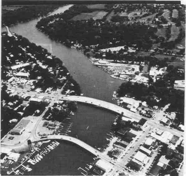
McHenry's Downtown is unique, consisting of not
one but three small separate commercial areas. In comparison with many downtowns, ours was still healthy, with few vacancies and little physical deterioration. Yet
important Downtown traffic generators were increasingly relocating to outlying sites.
Gann Associates prepared detailed plans for each of
these areas. The Bull Valley Corridor Plan was based on
the development policies already chosen. But here
again, the consultant prepared three alternative plans
for us to choose from. The Downtown Plan similarly
presented six strategy options for the future of our
central business districts.
5. Flexible Two-Part Format
Our previous Comprehensive Plan had become
outdated and was no longer used after less than ten
years. The City's growth was partly to blame, but so
was the Plan's traditional rigid format. The new Plan is
designed to be more flexible to allow it to remain useful
as conditions change.
The status of a proposed expressway to the north of
the City perhaps best illustrates our need for flexibility.
On the drawing board for many years, it had never
been built. With the recent relocation of the Sears Merchandising Group from Chicago to the northwest suburbs and the successful completion of a toll road
through DuPage County, there was renewed interest in
the need for new highways in the area. One proposal
would have given us our highway but routed it west of
the City instead of the previously planned alignment
north and east.
June 1991 / Illinois Municipal Review / Page 21
We knew such a road would have great effect on the
development of McHenry, but there was no way of
determining where it would have this effect.
Our Plan was accordingly presented in two parts.
Part one was the Development Policies a verbal
statement of flexible policies for residential, retail, industrial, open space, downtown development, streets,
and interchange area development. The second part
was the Plan Map a location-specific map indicating
future land use.
The Development Policies were designed to serve
as a policy guide that would not have to change even as
the City changed. The Plan Map, on the other hand, was
specifically designed to be amended with a changing
development situation. In this way the Plan recognized,
as many plans do not, that things will happen that the
planners never anticipated. But it also recognized our
need to have some consistent policy over the years
despite changing conditions.
The Plan Map accordingly shows the planned expressway in the traditional alignment north of the City.
But the Development Policies on expressway interchange development can apply even if the western
alignment is finally selected.
Our Plan Commission and City Council members
represent a variety of perspectives and interests. While
this is necessary and even healthy, it is not always easy
to reach agreement. The flexible nature of our plan
allowed its adoption by both the Commission and the
Council. While the Plan is in some respects very
general, a more specific plan might not have achieved
the acceptance and comfort level that even our elected
officials appear to have with this Plan.
6. An Amendable Plan
McHenry has for years periodically amended its
plan to reflect land use decisions made from time to
time as a result of changing circumstances. While these
amendments were done by ordinance, they never appeared on the plan map or in the plan document, since
neither was designed to accommodate changes.
Our new Plan is designed to be amendable. The
presentation-scale Plan Map consists of film colors and
tapes on acetate overlays super-imposed over a base
map. The designations for land uses, facilities, and
highways can easily be replaced with updated information. And the Development Policies are on a computer
file that allows easy update of their verbal provisions
should that become necessary.
Conclusion
We did our plan update our way. It was not the
traditional way to do a comprehensive plan, and it is not
necessarily the way other Illinois municipalities should
approach their planning. While we used professional
help, we remained in control of the policy decisions.
But as a result of our active participation and our
consultant's willingness to be flexible and tailor a plan
to our needs, we achieved a plan our City Council can
live with. Given the history around the state of plans
prepared to reflect only the priorities of planners or
plan commission members that as a result never see
implementation, this may be more of an accomplishment than it appears.
Page 22 / Illinois Municipal Review / June 1991