GROUNDWATER:
WHERE IT COMES FROM,
WHERE IT GOES
By SAMUEL V. PANNO, Illinois State Geological Survey
Have you ever wondered where the water in a well
comes from? Does yours draw from an underground
river or lake? Groundwater is water present in the tiny,
often microscopic, interconnected pore spaces between grains of sand and gravel and in open crevices in
rock (Figure 1). It is the source of drinking water for
half of the state's residents and almost all of its rural
residents. However, groundwater resources are not
uniformly distributed and can be contaminated and/or
depleted by careless, wasteful habits.
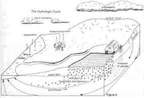
The water from rain and melting snow that infiltrates the soil and is not used by plants travels downward to the water table; below the water table soil or
rock is saturated with groundwater. Because ground-
water comes mostly from precipitation that falls locally, the water table may fluctuate several feet as a
result of seasonal changes, droughts, and periods of
heavy rain.
Under the force of gravity, groundwater generally
moves from higher to lower elevations, through the
connected pores and crevices of rocks and sediments,
until it discharges to a stream, spring, or pumping well.
Streams that flow even when no rain has fallen for
several weeks or months are being fed by groundwater.
Once discharged into a stream, the water begins its
journey at the surface. In Illinois, surface water and
groundwater flow to the Mississippi River and then to
the Gulf of Mexico. During its journey and after joining
the Gulf, water evaporates, eventually forming clouds
. . . and the cycle begins again. This cycle of water
movement is referred to as the hydrologic cycle (Figure
2).
An aquifer is a body of rock or sediment that will
yield water of usable quantity to a well or spring. Clay-
rich glacial deposits and shale, which have low permeability and do not conduct water, act as confining
beds, restricting the movement of groundwater. Thus,
aquifers act as conduits bounded by less permeable
materials. Because groundwater moves through very
small spaces between the clay, sand and gravel, it
moves very slowly — at rates that range from feet per
day to only inches per hundreds of years. However, a
well in a good sand and gravel aquifer can pump millions of gallons of water per day. Sand and gravel
aquifers in Illinois produce 58 percent of the ground-water used; the remaining groundwater is produced
from bedrock aquifers.
Geology has a major influence on the availability of
groundwater. Glaciers that once covered most of Illinois deposited a blanket of materials covering the bedrock to depths of up to 600 feet. Clay-rich materials
comprise much of the glacial deposits. However,
June 1991 / Illinois Municipal Review / Page 27
streams flowing from the melting glaciers deposited
broad sheets and long, narrow bodies of sand and
gravel that now act as aquifers.
Bedrock aquifers were formed in a different
manner. These aquifers were deposited hundreds of
millions of years ago as layers of sand and fragments of
seashells in oceans that covered the land. These layers
hardened into sandstone and fractured limestone or
dolomite aquifers.
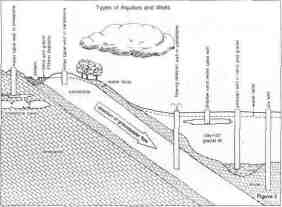
There are two main types of aquifers: the unconfined or water table aquifer and the confined aquifer
(Figure 3). Unconfined aquifers, recharged through
direct infiltration of rain water, are found in counties
with very sandy soils such as Mason, Kankakee and
Whiteside where aquifers lie only several feet below the
surface. Confined aquifers are covered by beds that
impede groundwater movement into and out of the
aquifer and cause the groundwater to be under pressure. The water level in a well in a confined aquifer is
above the top of the confined aquifer; this is referred to
as an artesian well. In flowing artesian wells, common
in southern Iroquois and northern Vermilion counties,
the water level is above both the aquifer and the ground
surface.
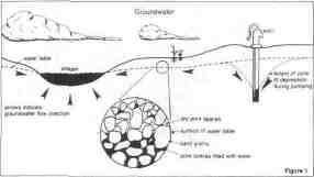
Tests to determine the specific capacity of a well
divide the pumping rate in gallons per minute by the
drawdown (vertical drop in water level in the well) in
feet. Pumping causes the development of a cone of
depression in the water table above the well (Figure 1).
To illustrate, imagine a snow cone with the crushed ice
as an aquifer and the syrup acting as groundwater. As
syrup is sucked out of the ice through a straw, the ice
fragments become whiter above the end of the straw as
the removal of the syrup creates a cone of depression.
Because aquifers are recharged at the ground surface, they are susceptible to contamination from anything (e.g., oil, pesticides, sewage) spilled on the
ground or buried. The substance can follow pathways
similar to those for groundwater. If the substance
reaches an aquifer, it may make the groundwater unfit
for use. It is very difficult to clean up an aquifer once it's
contaminated, and the process may be prohibitively
expensive.
Limited information exists on contamination of
aquifers by agricultural chemicals. Because some of
these chemicals are toxic at low concentrations, their
occurrence has raised concerns. Detection of
agriculture-related groundwater contamination in
neighboring states suggests that aquifers in Illinois may
be at risk. Research at the Illinois State Geological Survey, a division of the Department of Energy and Natural Resources, and other agencies is addressing this
issue.
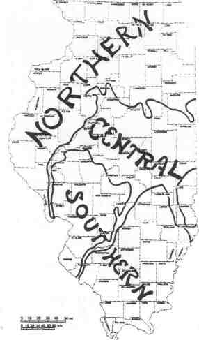
NORTHERN ILLINOIS
The availability of groundwater and the types of
aquifers vary across the state. The northern third of
Illinois relies on groundwater from three sources: (1)
glacial sand and gravel aquifers; (2) shallow dolomite
aquifers; and (3) deep sandstone aquifers. The dolomite is fractured and has solution features. Where there
are glacial deposits, groundwater that moves downward through them recharges the shallow dolomite
aquifers. In the western and northwestern parts of the
state where these rocks are exposed at the surface (e.g.,
Jo Daviess and Calhoun Counties) there is recharge
directly into the shallow dolomite aquifer. Relatively
large quantities of groundwater of predictable quality
are produced from the deep bedrock aquifers. The
earliest wells in the northeast in the deep sandstone
system had flowing artesian conditions. Heavy pumping from these aquifers near and in Chicago that began
after 1864 has formed deep cones of depression that
have dropped water levels in wells as much as 800 feet.
Small drops in water levels in these deep aquifers can
be detected more than 50 miles from Chicago.
CENTRAL ILLINOIS
The availability of groundwater and the types of
aquifers vary across the state. The dominant source of
groundwater in central Illinois is layers of sand and
gravel deposited by melt waters of the large continental
Page 28 / Illinois Municipal Review / June 1991
glaciers that once covered much of the state. The most
productive aquifers of this type are located adjacent to
the valleys of the Mississippi, Illinois, Ohio, Wabash,
Kaskaskia, and Embarras Rivers. Ancient river valleys
eroded into the bedrock also are buried beneath the
glacial materials. The Mahomet Valley Aquifer is an
example of a major bedrock valley located in east-
central Illinois. Its sand and gravel deposits are up to
200 feet thick, and it is buried under 100 to 200 feet of
glacial till. The aquifer underlies nine counties, ranges
from 8 to 18 miles in width, and provides a source of
water for irrigation, industrial, and municipal uses.
Groundwater withdrawal from the Mahomet Valley
aquifer is at least 42 million gallons per day. Thinner,
near-surface beds of sand and gravel, used by rural
citizens as sources of water, lie above the aquifer.
SOUTHERN ILLINOIS
The availability of groundwater and the types of
aquifers vary across the state. The topography of
southern Illinois was sculpted by running water from
melting glaciers, although some of the northern-most
part is overlain by relatively thin glacial deposits. Sand
and gravel, deposited by running water from melting
glaciers, is found along courses of present-day streams,
The most important aquifers in southern Illinois consist
of deposits of sand and gravel that lie above bedrock.
Sand and gravel deposits range from inches to up to 50
feet thick; layers several feet thick often are suitable
aquifers. Wells in these deposits provide water for municipal and farm supplies. Thinner, less permeable
deposits require large-diameter wells to produce water.
In upland and far southern areas where glacial till deposits are absent, bedrock deposits of sandstone and
fractured limestone will usually provide water for domestic and farm supplies. Limestone and dolomite that
make up the bedrock transmit water mostly through
fractures and solution features. Wells drilled into these
rocks yield water only if permeable features such as
fractures are intersected; the location of these features
is difficult to predict. The St. Louis and Burlington-
Keokuk limestones contain the most fractures and are
usually dependable sources of fresh water for farm and
domestic use. Mississippian sandstone, especially the
sandstone of the Aux Vases Formation, are most permeable and contain fresh water in the south-central
area. Unfortunately, the quality of groundwater decreases with depth because of the salinity of deeper
waters in the bedrock aquifers of southern Illinois.
Further information on groundwater protection,
conservation or location of these resources is available
from the Illinois State Geological Survey, 615 E. Pea-
body Dr., Champaign, IL 61820-6964. •
June 1991 / Illinois Municipal Review / Page 29