|
Home | Search | Browse | About IPO | Staff | Links |
|
Home | Search | Browse | About IPO | Staff | Links |
|
Rapid transit from Loop to Midway:
Chicago's public transportation riders might have been caught unaware June 6 by the balloons, cake and Dixieland music. Whether they realized it or not, they were invited to a birthday party. The Chicago Transit Authority (CTA) celebrated the 100th anniversary of Chicago's first elevated train. The rapid transit gets a belated birthday present in the upcoming months: a new rapid transit line linking the southwest side's Midway Airport to downtown. Construction is scheduled for completion in October, and full service is set to begin early next year. The route is expected to handle 119,000 riders per day. It comes none too soon for the southwest side, which has waited decades for service while rapid transit lines have reached the rest of the city. The lack of a line has handicapped the southwest side. "People who live around 4800 North Western are as far from the Loop as people at 47th and South Western but get there in half the time," comments Jim Capraro, executive director of the Greater Southwest Development Corporation, a community development group dedicated to the revitalization of the southwest side Chicago Lawn community. The new southwest side transit line should do more than improve riding times. It could create profound economic and sociological changes for what is now the most isolated part of the city. Improved retail shopping is one early consequence of the new line. So are the twin blessings of housing at still reasonable costs and expected improvement in the value of those homes and other property. The rapid transit line means better access to jobs in the boom areas of downtown and nearby suburbs. It also opens up the southwest side to racial diversity in neighborhoods where such diversity has not always been welcome. Wherever elevated lines have travelled in Chicago, change (and often neighborhood prosperity) have been passengers. The first elevated rapid transit line in the city, finished in 1892, connected Congress and 39th Street (now Pershing Road) by running through an alley near Wabash. Passengers could get from the Loop to the near south side in only 14 minutes — half the time required by cable cars. A year later, the line was extended to 63rd Street in time to whisk visitors to the Columbian Exposition. Another line, built over Lake Street, opened the west side to the Loop. The original el immediately exerted a profound influence both downtown and in the neighborhoods served by the trains. The "Loop" formed by the elevated tracks circled downtown, one of the most concentrated business districts of any U.S. city, with major office buildings, department stores, public agencies and railroad terminals built within or near the elevated lines. With the el, once-distant communities like Ravenswood, Austin and Rogers Park turned from quasi-suburbs into city neighborhoods. "It played a crucial role in the formation of the modem urban neighborhood with its characteristic brick apartment buildings, shopping strips, and a concentrated but highly mobile population," notes Columbia College history professor and lifelong southwest side resident Dominic Pacyga in his book City Neighborhoods. The elevated system grew like the city — rapidly and haphazardly. Even though the Lake Street line served the August & September 1992/Illinois Issues/33 west side, a Metro West Side Line went to Garfield Park, Douglas Park and Logan Square. The Lake Street and Metro West Side lines were run by two different companies, which explains their close proximity. Public transit ridership in the city fell off after peaking at one billion riders in 1926. Shorter work weeks, increased automobile ownership and growth of outlying shopping areas hastened the decline of ridership. The city with its CTA took control of the rapid transit lines as well as trolleys and buses in 1947 because many of those lines faced financial problems. Rapid transit affected economic patterns. Ever since the first line connected the Loop and Jackson Park, shopping areas have grown around many of the el stops. Even in the early 1900s there were "reverse commuters" who rode to work away from the Loop. The Douglas Line, for example, linked west siders to jobs at the nearby suburban Western Electric plant. Just as the presence of a rapid transit line affected communities, so did its absence. For years no rapid transit line extended to the northwest side, and merchants at the Milwaukee-Irving Park-Cicero "six corners" business district prospered since the neighborhoods had no quick route to downtown shopping. A similar "captive audience" mentality caused businessmen in the south side Englewood neighborhood to oppose the entry of rapid transit lines into their community; in the 1960s, an elevated line was finally extended to Englewood.
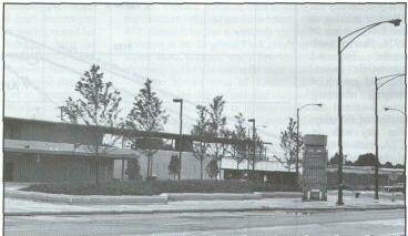
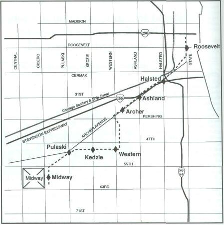
The first wave of rapid transit construction ended before 1920. The next major phase took place in the 1960s when routes were literally shaped by the automobile. "When the original els went in, they wanted to get spots where the customer could walk on," notes transportation writer Ron Grossman. In the 1960s the new lines often had stops far from residences. They ran alongside cars in specially designed median areas along the expressways — the northwest side's Kennedy, the west side's Congress and the south side's Dan Ryan. By the end of the 1980s, most of Chicago lay within the range of rapid transit lines. The exception was the southwest side. "In hindsight, it might seem strange that the southwest side was bypassed when it came to rapid public transportation," according to George Krambles, a former CTA executive director and lifetime rapid transit buff. "But there was a valid reason at the time. Public transportation is very population intensive; it needs a lot of riders to justify its existence. But when the earliest lines were built, the type of industry the southwest side was attracting was that which 34/August & September 1992/Illinois Issues didn't use a lot of people but did use a lot of space." The southwest side has undergone change since those early days. Although the areas near the river remained low in population and heavy in industry, "bungalow belt" communities to the south such as Back of the Yards, Gage Park, West Elsdon, West Lawn and Chicago Lawn gained population. By the 1950s demand existed for a fast transit line to the Loop, but no funds were available. Ironically, a highway project led to the funds for the southwest side transit line. In the 1970s, Chicago Mayor Richard J. Daley proposed a Crosstown Expressway which would link the northwest and south sides by means of a freeway running through the western part of the city. The expressway was rejected after loud community protest. Federal funds, however, had been appropriated for the project. William Lipinski, then an alderman from the southwest side 23rd Ward, persuaded then-Mayor Jane Byrne in 1980 to "de-designate" the Crosstown funds and redirect them toward a southwest side rapid transit line. Lipinski followed through after he went to Congress in 1982 and got a seat on the Public Works committee, important for any urban public transportation project. "There was a proposal for military aid for the Nicaraguan contras in 1983, and I voted for it. About a week later I got a telephone call," the congressman remembers. "President Reagan called me to thank me for my vote. He asked, Is there anything I can do for you?' I answered, 'There's nothing you can do for me personally, but there's something you can do for my constituents.' " The result was financial backing for a $521 million transit line connecting Lipinski's district with downtown. So far the rapid transit line has been doubly miraculous, according to Lipinski. "It's built on schedule and below the original cost estimate," he claims. "The original timetable had construction beginning in 1988, but we got it underway in 1987 when $45 million in start-up funds were freed up." According to Lipinski, the rail line itself should be finished in October or early November, with service beginning in early 1993 when cars for the line are received. The new rapid transit line circles the Loop before starting its nine-mile run to Midway via the southwest side's working-class bungalow belt. From the Loop it goes south to State and Roosevelt. At 17th Street, it juts off from the Dan Ryan line, and after a few blocks on elevated tracks, it travels southwest on a railroad embankment starting at Canal Street. The line runs a zigzag pattern which is no accident. It eliminated any residential displacement that would have been necessary on a straight Archer Avenue route. It also takes maximum advantage of available surface space, thus cutting down the need to build elevated structures. First stop is Archer and Halsted, an area currently inhabited by an Italian deli, a party center, an auto repair shop and a few houses. Shortly afterward it cuts to slightly north of the Stevenson Expressway. This is the northern portion of Bridgeport, one of the city's oldest neighborhoods, newly prospering thanks to Chinese and Mexican immigration. Ashland Avenue is the next stop. No business or residences are nearby, but the large River Side Square shopping plaza is two blocks south. The line travels further southwest to a stop just north of Archer at 35th Street. The el-rider can find a video store, bridal shop, supermarket, real estate office, chili parlor and McKinley Park, a large park crowded on weekends with baseball-playing kids and softball-playing adults. The surrounding McKinley Park neighborhood is slightly newer and more affluent than the older section of Bridgeport. After this stop, the line leaves the railroad embankment and becomes elevated again. It turns south at Western Avenue, then doubles back southeast, joining another railroad embankment at about 41st Street. At 47th Street it begins a westerly move. Next stop is 49th and Western in the Brighton Park neighborhood. At the stop is a liquor store, pizzeria and a few houses. A supermarket and shopping plaza are one mile west at 49th and Kedzie. Three blocks west of Kedzie, the line veers slightly southwest, leaving its railroad embankment just east of the Pulaski station. This is a busy multicommercial street in Archer Heights, close to a large residential neighborhood inhabited by blue- and white-collar workers. The line next moves south and west to 59th Street to its terminus about a quarter mile east of Midway Airport. A pedway linking the el terminal to the airport is scheduled for completion next spring. Also planned but dependent on funding is an extension of the line south to Daley Junior College and Ford City shopping center. Even without a single train running, the area has already undergone changes. Shortly after the CTA announced its intention to build the line, Kedzie Plaza, a shopping center at 49th and Kedzie, started up. Since then, two shopping plazas on Pulaski and the one on Ashland have opened. Other businesses have sprouted up along the new line, including a Mexican restaurant called the L Stop on Archer Avenue. And there is parking. Planners for the southwest side line, recognizing the attachment of southwest siders to their cars and the need for parking, built "park and ride" spaces near several of the stops. The Pulaski, Western/49th and Midway stops have 800 such spaces among them. Property values on houses near the new line's stations have already begun to leap. "Home values are up in Gage Park and West Elsdon as much as 25 percent," says Jeff Bartos, executive director of the Southwest Catholic Cluster Project, a church-based organization which seeks to promote racial and cultural diversity in the area. The line already has affected the neighborhoods," notes Capraro. "Changing real estate values serve as testament to the effect of the advent of the line." Even with such an increase, home values on the south-west side remain considerably lower than similar houses on the northwest side. A 1991 booklet written by Capraro and published by the Cluster and Southwest Development pictured two similar bungalows: a northwest side Jefferson August & September 1992/Illinois Issues/35 Park home valued at $119,000 and a Gage Park home valued at only $59,000. Housing values, however, were not the main reason for the booklet's publication. It addressed the fears many white southwest siders have about racial change in light of the arrival of the new rapid transit line. Over the years, the southwest side has not exactly earned a reputation for racial harmony. Martin Luther King was hit by a rock during a 1960s demonstration in Marquette Park. While groups such as the Southwest Catholic Cluster Project and the Greater South-west Development Corporation have made inroads in promoting racial harmony, antagonisms still exist. From 1986 to 1991, the Marquette Park neighborhood (directly south of the rapid transit line), led the city in reported hate crimes. As late as last spring, congressional candidate Art Jones ran on the platform of allowing homeowners to decide who may or may not move into their neighborhood. The 1992 booklet, 60,000 copies of which have been distributed, does not try to win over hearts. Instead, its message aims at parishioners' wallets. "Don't be alarmed if some of the new qualified homebuyers are of different ethnic or racial backgrounds!" says author Capraro. "As the number of these people who are seeking to buy Southwest Side homes increase so will local home prices.... If on the other hand, potential buyers become uneasy because of a potential for 'ethnic trauma' they will choose not to live here. ... If they don't select our community prices will not increase. IT'S A MATTER OF SIMPLE ECONOMICS." Other, subtle, devices have been used to allay racial fears. "A lot of people here, when they think of the el, associate it with the ghetto," says Pacyga, a volunteer with the cluster project. "So CTA people are careful to always call it the 'rapid transit.' "
integration in every parish on the southwest side. Nobody has complained' " For sale" signs have appeared near the el stops, but these may be due to factors other than racial fears. Some may come from elderly people (nearly one-fifth of the Gage Park residents are age 65 or older) who might be selling their homes anyway. Others may come from people who simply want to sell at a profit. "I've spoken about racial integration in every parish on the southwest side. Nobody has complained. The people who get upset about these things have already left the neighborhood," says Pacyga. Ed Marciniak, president of the Institute of Urban Studies at Loyola University, offers a slightly different view: "What people are betting on is rapid transit as an inducement for whites to move into the areas. For the stability that comes from neighborhood integration, there has to be an influx of whites, such as city workers required to live in Chicago, to replace the white retirees who die or leave the city. Families moving into the southwest side could rejuvenate an area which has been losing population for decades. This could be a major factor in the rebuiliding of the center city." Transportation links set up through the rapid transit line may be as important as the train itself. Only 17 percent of the route's riders were expected to walk to the trains, as opposed to 71 percent arriving by feeder bus and 12 percent by car, according to an environmental impact study. Most of the line's stations are planned with accompanying off-street bus stops. Plans also have been made to help access to suburban job markets by routing PACE (suburban) buses to the Midway terminal. For the residents of the southwest side, this new rapid transit route increases their accessibility to employment throughout the metropolitan area, including suburbs where many cannot afford to live, according to David Larsen, project director for the southwest rapid transit. "Likewise," he adds, "suburbanites can get a quick, inexpensive, hassle-free ride to jobs downtown." The Southwest Rapid Transit Line may be part of a larger rapid link uniting the outer regions of the city. This public transportation version of the Crosstown Expressway would connect O'Hare and Midway with the proposed Lake Calumet airport. "It's more than a dream, but there's no formal planning yet" admits Harry Hirsch, director of operations for the city's Department of Planning. The Lake Calumet airport failed to gain General Assembly approval during its spring session, but Hirsch refuses to discount a three-airport hookup. He said in July, "There has been informal discussion of the O'Hare-Midway linkup, even if Lake Calumet is stillborn. But it's still uncertain that the project is dead. If it resurrects, there remains a good chance of a three-airport hookup." Failure of Lake Calumet to get off the ground as a new airport likely means that Midway Airport will stay open. But what would happen if Midway closes? Capraro predicts the impact on the transit line would be minimal. "The south-west line is not really built to be an airport line. Those going to Midway were projected to be only 5 or 10 percent of all travellers. And those using it are less likely to be air travellers than airport employees." "Employees" is the key. "The most fundamental aspect for this rapid transit line is providing access to the workplace. Everything else is icing on the cake," Capraro comments. "It makes all the difference in the world for the stability of this community." Ironically, that stability may come through the greatest change the southwest side has experienced in decades. David Fremon is a Chicago writer and author of Chicago Politics: Ward by Ward. 36/August & September 1992/ Illinois Issues |
|
|