|
Home | Search | Browse | About IPO | Staff | Links |
|
Home | Search | Browse | About IPO | Staff | Links |
|

Michael D. Sublett and Frederick H. Walk Ask a real estate broker to list the three most important determinants of the value of an urban dwelling or commercial site, and you are likely to hear this amazingly simple answer: location, location, and location. Illinois is located in the Midwest, with only a thin line separating it from neighboring states. Like every other fixed feature on the earth's surface, the Illinois boundary really has two locational characteristics. First, and most obvious, is its absolute location a series of points precisely definable in terms of some reference system such as latitude and longitude. Second, but equally important, is its relative location a concept that requires us to think of a boundary's connections with its surroundings. Such connections, of course, can and often do change with the passage of time.
ABSOLUTE LOCATION
Eastern Boundary
That meridian, undeclared in the nineteenth-century boundary descriptions, lies 87 ° (degrees) 30' (minutes) west of the Greenwich Meridian. Oddly enough, from 1818 until the United States adopted Greenwich as its prime meridian in the 1880s, the Vincennes courthouse would have been only 10° 30' West Longitude, as Washington, D.C., for decades marked the official prime meridian for America. The Illinois-Indiana line stretches straight north from the Wabash meridian intersection to the northwest corner of the Hoosier State, which means the line extends a few miles out in Lake Michigan. At that corner the line turns eastward along a parallel, 41° 50' North Latitude, until it reaches the centerline of Lake Michigan. Irregular and conforming to the points that constitute the lake's centerline, the eastern boundary where it separates Illinois from the state of Michigan terminates where the parallel 42° 30' North intersects the centerline. Most state maps fail to depict the eastward extension of Illinois into the lake, and thus most people fail to count Michigan among Illinois' neighbors.
Northern Boundary
2 significant, however, was the last-minute shift in 1818 of the boundary from its intended location at 41° 44' North to 42° 30' North, a distance of approximately sixty miles. That deviation from the boundary prescribed in the Northwest Ordinance of 1787 increased Illinois' territory by nearly 20 percent, an area roughly equivalent in size to Massachusetts.
Western Boundary
Southern Boundary
RELATIVE LOCATION
An Eastern Example
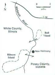
Bull Island, as locals had long called the cutoff land, lay east of the Wabash, but because of the Rio Grande Rule it remained under the jurisdiction of White County, Illinois. Festival promoters kept secret their plans to locate at Bull Island. They hoped to be so far into the preparation of facilities and ticket sales that no judge in Carmi, the seat of White County, would dare issue an injunction forbidding the event. It appears that the shrewd promoters and the White County officials recognized a splendid advantage conferred by Bull Island's cutoff status: land access to the five hundred-acre site lay entirely through Indiana (Figure 3). Therefore, state police and local authorities from Indiana would share with Illinois the responsibility for solving traffic snarls and for closing 1-64 as 250,000 frantic fans tried to reach Bull Island over the Labor Day weekend. Suddenly a backwater segment of the Illinois-Indiana boundary emerged for a brief but spectacular time in the regional, even national, spotlight. In
3
other words, its relative location underwent a great metamorphosis before the island returned to obscurity.
A Northern Example
The displaced boundary was a sore point for several decades after 1818. Displeasure peaked in the 1840s as Wisconsin sought to convert from territorial to state status. Many Wisconsin politicians called for shifting the boundary back southward. Agitators stirred up settlers in the northernmost of Illinois counties with talk of secession from Illinois and affiliation with the emerging state of Wisconsin. Frequently, residents of those northerly Illinois counties expressed a desire to make the switch. After all, they felt a closer bond with Wisconsinites than with the southern-born folk who still held sway in Springfield. Officially, the dispute ended in 1848 when Wisconsin accepted the limits Congress established for it at the time of statehood. Unofficially, some were still griping years later about the loss of eighty-five hundred square miles of land, the Chicago portage connection to the Mississippi Valley, and the lead mines near Galena.
A Western Example
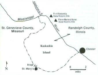
From prehistoric times into the late-nineteenth century, Kaskaskia was not an island but rather a place where the Mississippi turned sharply westward in a meander that stretched nearly bluff to bluff. Inside this meander, near the eastern bluff and beside the Kaskaskia River a left-bank tributary of the Mississippi French settlers established the village of Kaskaskia, which became the first capital of the new state of Illinois. In 1881 the Mississippi, at the height of a major flood, cut off the big Kaskaskia meander and occupied (as it does to this day) the lower few miles of the old Kaskaskia River channel. Illinois has retained control of the island through a lengthy series of court battles with Missouri, whose officials have looked longingly at the tax money generated by the twenty-three thousand acres of prime bottomland now separated from the Illinois mainland by the big river. That separateness has proven a considerable inconvenience for the island's farmers and few remaining residents. Those folk, barring the use of a boat or aircraft, must enter and exit their Illinois island through St. Mary's, Missouri.
A Southern Example
4
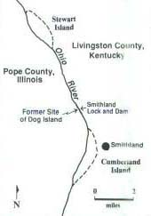
northern boundary. Of course in many matters, such as navigation, Kentucky must bow to federal regulations; but when Ohio, Indiana, or Illinois test the jurisdictional waters hoping to find a Kentucky weakness, the Bluegrass State comes out swinging. At issue most often are dollars the state reaps from control of the Ohio River. As recently as January 1993, Kentucky officials were flexing their boundary muscles in response to an Illinois scheme to collect taxes from a floating casino tied up at Metropolis, Illinois. Then there was the matter of Dog Island (Figure 2c). Unlike Bull Island and Kaskaskia Island, Dog Island was not the result of a meandering river. In fact, this tiny (130-acre) speck of silt and sand in the Ohio, twelve miles northeast of Paducah, Kentucky, was not even an island at low water, according to Illinois advocates, including Illinois' Attorney General in the 1970s, William Scott. Illinois claimed attachment of Dog Island to the Illinois side of the river as a peninsula when the Ohio was especially low. Dog Island (Peninsula?) suddenly came into prominence in the early 1970s when the U.S. Army Corps of Engineers announced plans to spend nearly $100 million there to improve river navigation.The Smithland (after Smithland, Kentucky) Lock and Dam project was to span the Ohio, crossing Dog Island in the process. Both Illinois and Kentucky wanted the tax benefits that the federal money would produce as workers labored on the project. The controversy bounced all the way to the Illinois Supreme Court and then into the federal courts. It matters little now who actually prevailed legally at Dog Island. The Smithland Dam stretches across the river, and tows lock through on their way up and down the river. However, one thing we can state with confidence: the courts have not heard the last of the Ohio River jurisdiction cases, as the relative location of that Illinois boundary again and again comes into question. Click Here for Curriculum Materials
5
|
|
|