|
Home | Search | Browse | About IPO | Staff | Links |
|
Home | Search | Browse | About IPO | Staff | Links |
|

Norman Moline and James Schebler The history of any place is linked inextricably with the movement of people, goods, and ideas to that place. Over the years people from different areas move to and from a place, influencing its demographic characteristics. The routes over which Illinois settlers traveled, the kind of transportation they used, and the timing of their movements influenced the patterns and density of settlement. To understand the context of those migrations, one needs to ask some key questions: Why were these settlers moving? What were the "push" factors (i.e., negative features of the previous location) and the "pull" factors (i.e., positive features of the new place) prompting the move and guiding the settlement selections? What were the site characteristics (the natural and human features of the place) and the situation characteristics (the relative locations) of the places chosen as destinations?
After a place's initial settlement, its social and economic characteristics are influenced by changes in movements of people, goods, and ideas. Some places chosen for their locational advantages for trade and communication continue to grow because of those advantages; other places decline because of transportation changes. Moreover, the evolution of the cultural landscape (the visible expression of culture) of any place is the result of countless different routes of diffusion of cultural traits from their points of origin into the new place. All of those topics are examples of the geography theme of "movement." Three particularly significant aspects of movement that are discussed regularly in books on Illinois history are reviewed here: (1) immigration to Illinois by Native Americans, by people who had been settled in the eastern United States, by people coming directly from overseas, and by African Americans moving from the southern U.S.; (2) transportation systems that facilitated their movements, such as rivers, canals, railroads, automobiles, and good roads; and (3) diffusion of material and non-material culture to Illinois.
Immigration
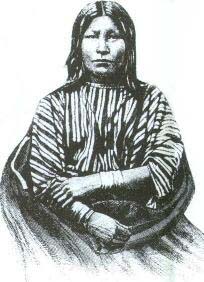
24 they have with other groups? What were the factors that prompted them to leave the area? Once Illinois became a territory (as part of the Indiana Territory in 1800) and then a state (1818), new settlers arrived in increasing numbers. The first settlers came primarily from the South, predominantly from Kentucky, Tennessee, and Virginia, using the Ohio River and its tributaries as their route. They settled in mostly wooded and hilly lands in southern Illinois. Douglas McManis in The Initial Evaluation and Utilization of the Illinois Prairies, 1815-1840, states they "sought areas which were unsettled, relatively inaccessible to other western immigrants and abounded in game, natural forage and timber." They brought cultural characteristics that shaped the society and cultural landscape. Following the Black Hawk War of 1832 and improvements in plow technology in the 1830s and 1840s, particularly the invention in 1837 and subsequent spread of John Deere's self-scouring steel plow that enabled easier cultivation of the prairie soils, the northern and central parts of Illinois became more attractive to settlers (Figure 1). About that same time a new route from the east was developed: the National Road. It was begun in Cumberland, Maryland, in 1811, completed through Pennsylvania, West Virginia, Ohio, and Indiana in subsequent decades, opened as far as Vandalia, Illinois, by 1840 and extended to the Mississippi River in the 1840s. Over that route, as well as the natural Ohio River route, came settlers from the middle Atlantic states, particularly Pennsylvania, who transplanted many of their cultural traits. People from New England and New York also began to arrive in greater numbers in the late 1830s, 1840s, and 1850s. This northern migration was facilitated by the Erie Canal (opened in 1825) across New York, the development of steamship travel on the Great Lakes, and the extension of railroads to and across Illinois, primarily to and from Chicago. Since those northerners or "Yankees" arrived with different expectations and more knowledge about the Illinois prairies than their southern counterparts, they were willing to farm the fertile large prairies to the north. Others chose to settle in the emerging towns and cities of northern and central Illinois. Yankees, in both rural and urban settings, introduced many of their cultural traits to this region.
Beginning in the 1840s immigrants from overseas began to arrive in Illinois. In the early period, Germany, Ireland, and the Scandinavian countries were the primary points of origin. Many immigrants came via the Great Lakes and railroad routes, the same migration path taken by settlers from the northeastern United States. In the early years of the western European migration, some immigrants settled in Chicago, while the majority moved on to farms. As Chicago grew to be a major industrial center, an increasing number of immigrants, predominantly from western and northern Europe, remained in Chicago. Near the turn of the century, eastern and southern Europe became major points of origin for immigrants. Later, Latin America, particularly Mexico and Puerto Rico, became a major source region for immigrants, particularly for people bound for Chicago. Immigrants from some east and southeast Asian nations also became a part of Illinois' emerging ethnic mix. While African Americans have been a part of Illinois' population for virtually all of its history, their migration out of the South and their presence in Illinois increased in the 1890s and most importantly, in the period 1910 to 1930. James R. Grossman in Land of Hope describes the Great Migration:
Other cities also benefited from African-American immigration. Grossman's Land of Hope provides an excellent account of this often neglected part of Illinois' migration history. The preceding generalizations of some of the origins, routes, and specific destinations of immigrants are an essential part of Illinois' cultural history. Yet the immigrant history of each county and municipality is unique. The arrivals of new settlers, their
25
numbers, origins, the routes they followed, and the human stories associated with them are central to understanding the histories of these places.
Transportation Systems
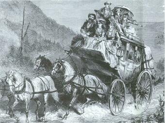
The large and extensive network of natural waterways that surrounds and penetrates Illinois has facilitated transportation. Native-American groups traveled the rivers and lakes in canoes and other vessels, trading with other groups within or outside the region. Some of the largest Native-American settlements were in close proximity to these waterways, notably the Mississippian culture site (Cahokia Mounds) near the convergence of the Mississippi, Missouri, and Illinois rivers, and the Sauk village near the junction of the Mississippi and Rock rivers. For settlers coming from elsewhere in the eastern United States, the Ohio and Mississippi river systems were the most important routes in the late 1700s and early 1800s. Settlers on flatboats and keelboats took advantage of the downstream current of the Ohio River. While upstream movement by such boats was difficult, it was possible, and settlers moved up such tributaries as the Wabash, the Embarras, the Little Wabash, the Big Muddy, the Kaskaskia, the Illinois, and the Sangamon. Though the first steamboat journey downstream on the Ohio and Mississippi rivers to New Orleans was in 1811, it was not until 1817 that the first northbound steamboat on the Mississippi reached St. Louis and 1820 that a steamboat reached Peoria on the Illinois River. In the early 1820s after the emergence of the lead-mining industry in northwestern Illinois, Galena became the major steamboat center on the Upper Mississippi. Steam traffic surpassed flatboat traffic by 1830. Alden Cutshall in Illinois Land and Life in the Prairie State suggests that this river system was the principal mode of transportation:
During the first few decades of the nineteenth century, Illinois faced south in its commercial relations. In fact, over half of the state still faced in that direction at the middle of the century and many communities continued to do so until the outbreak of the Civil War. The steamboats also had a major impact on Great Lakes navigation. The first steamboats appeared on Lake Ontario in 1816 and on Lake Erie in 1818, but they did not emerge as important carriers of people and goods to and from Illinois until the 1840s and 1850s, which signaled a significant switch in the commercial orientation of the state from the south to the north and east. Despite the good natural waterway system in the eastern United States, there were some gaps that had challenged human ingenuity and engineering capabilities for years. The completion of the Erie Canal across New York state in 1825 not only provided an effective link between the Atlantic Ocean and the Great Lakes (and thus a good westward route for migrants), it also served as an example of the feasibility and potential value of canals. For many years there had been an interest in bridging the gap between the Mississippi River system via the Illinois River with the Great Lakes system. In 1830 construction began on the Illinois and Michigan canal, and it opened to traffic in 1848. According to Cutshall,
For a short period the canal was a major factor in the economic development of the state .... Grain grown along the Illinois and upper Mississippi Rivers could be shipped to market by way of the canal and Great Lakes at less cost than by way of New Orleans .... The canal showed a profit until 1879, and tonnage declined rather consistently after the peak year of 1881. There were other canals of varying degrees of importance, including two in the Chicago area the Chicago and Sanitary Ship Canal (opened in 1900 and improved in 1933) and the Gal-Sag Channel (opened in 1922) and the Illinois and Mississippi Canal, commonly called the Hennepin Canal (opened in 1907), which provided a shorter link between the Illinois and upper Mississippi rivers. 26 The first railroad in Illinois began operation in 1839, and the following year 26 miles of track were in use. Moderate growth occurred in the 1840s when total mileage increased to 118 miles. But the 1850s was the decade of major expansion. By 1860 there were 2,799 miles of track in Illinois, and the railroad's position as the dominant mode of transportation had been established. One of the most famous railroads constructed in the 1850s was the Illinois Central. Desiring a north-south link in the interior of the country, the federal government for the first time made land grants to aid in the construction of the route that would stretch from Illinois to the Gulf Coast. The Illinois Central had two main branches extending north from Centralia in southern Illinois, one through the center of the state to LaSalle-Peru on the Illinois River and then northwest to Galena (completed in 1855) and the other from Centralia to Chicago (completed in 1856). "With more than 700 miles of track at that time, the Illinois Central was the longest on the American continent," declares Cutshall. Another noteworthy line was the Chicago and Rock Island, which reached Rock Island in 1854 and two years later became the first railroad to cross the Mississippi River. With these and many other rail lines established across the state, Illinois had a system of transportation for effective movement within and beyond the state. With the completion in 1869 of the first transcontinental railroad, from Chicago to San Francisco, Cutshall writes, Illinois "became the keystone of the American railway system, and Chicago emerged as the world's greatest railway center." William Cronon's Nature's Metropolis provides an excellent in-depth discussion of factors accounting for the emergence of Chicago as a great city.
The next major transportation development involved the automobile and road improvement. By 1900, seven years after the first automobile was driven in the United States, there were 600 automobiles in Illinois. With the introduction of the Model T Ford in 1908 and a system of mass production that allowed prices to drop consistently over the next eight years, automobile ownership became economically possible for many Americans. Automobile ownership in Illinois soared from 6,060 in 1905 and 34,860 in 1910 to 173,832 in 1915, 504,250 in 1920,1,103,026 in 1925, and 1,430,809 in 1930. When trucks, buses and other vehicles are figured in, there was a total of 1,646,127 motor vehicles in Illinois in 1930. Those numbers remained fairly constant through the Depression and World War II, and by 1945 there were 1,508,834 automobiles and 1,734,252 total motor vehicles. With the arrival of the automobile, there was a significant push for new roads. In 1900, when the National Good Roads Association was established, there were only 26 miles of permanent rural roads in Illinois. In 1913 the Tice Bill provided a state-aid system of highways financed by state and county funds. In 1918 and again in 1924 the voters of Illinois approved bond issues for 4,700 miles and 5,100 miles of hard-surface rural roads. The number designations of the roads included in these bond issues endure as the route numbers for many of Illinois state highways with numbers under 100. Following the policies set forth in the 1916 Federal Aid Road Act and its 1921 revisions, Illinois identified some of its roads as federal-aid roads, which were included in the 1925 federal plan for designating and numbering U.S. highways. Those U.S. highways were supplemented significantly by the Interstate Highway System begun in 1956 and remain some of the main transportation arteries of Illinois. The coming of the automobile and the improvements in roads had a revolutionary effect upon the mobility of average citizens. Day-to-day life could take place within an expanded spatial dimension; distant places now could be reached in shorter time and with greater ease. For the first time there was a mechanized transportation system at the disposal and under the control of individual citizens; no longer were the times and directions of longer distance travel dictated or strongly influenced by railroads. With those changes in individual mobility came the collective changes on the settlement, economic, and cultural systems of Illinois. As individual life patterns changed, each municipality and county experienced a variety of changes. Encouraged or threatened by changes prompted by the new mobility, individual residents and collective groups expressed concern for the "place identity" of their towns and cities. (Norman Moline's Mobility and the Small Town, 1900-1930, describes the arrival and impacts of these changes in one Illinois county.) Those changes and responses are central to an understanding of Illinois in the twentieth century.
27
Origins and Diffusion of Culture Traits
Rectangular land survey system. The rectangular land survey system was created in 1785 and 1787 in conjunction with the Northwest Ordinance and then implemented initially in eastern Ohio. Intended as an orderly method of transferring land from the public domain to private ownership as settlement expanded westward, this survey system has had a major impact on the total landscape because of its directional and rectangular influence on the shape of field patterns, crop patterns, road alignments, and township and county political boundaries. Individual farms. The tendency for Illinois farmers to live on individual, dispersed farms rather than in agricultural villages (the pattern in most of the world) was established early in the history of the U.S. in eastern locations such as New England, Pennsylvania, and the South and carried west by settlers. Grid pattern. The grid pattern that is so common in towns and cities in Illinois has a long history in both the Old and New Worlds. In the U.S. it was used very early in such cities as New Haven, Charleston, and Philadelphia, and it diffused westward. Richard C. Wade in The Urban Frontier writes:
From the earliest days residents and civic leaders had a vision of the kind of city they wanted to build. This image was drawn from the great metropolises of the East.... Though Western towns drew upon the experience of all the major Atlantic cities, the special source of municipal wisdom was Philadelphia .... It was the model metropolis .... From street plans to cultural activity . . . , the Philadelphia influence prevailed. In addition to the grid pattern, the system of naming streets by numbers and tree types in Philadelphia also diffused widely among Illinois towns where to this day combinations such as 3rd and Walnut and 2nd and Elm are quite common. At the same time or in later decades, when New York was emerging as the premier city in the U.S., some towns and cities in Illinois chose to follow the New York system of numbered streets and avenues, for example, 5th Avenue and 42nd Street. Public square. The tendency of some Illinois towns and cities to have an open public square somewhere near its original center stems from the New England common or green (the Boston Commons and the New Haven Green are among the notable), which can be traced back to England. At the same time, the frequent practice of locating the county courthouse on a separate square at the core of county seat towns derives primarily from the South. Place names. The names given to natural and human features, particularly to towns, cities, and counties, show a rich mixture of origins and diffusions. Many Illinois names were repeats of names found elsewhere in eastern U.S. or Europe, names of famous people in American history, names of early settlers, Indian names, or names of natural features. (George Stewart's Names on the Land is a good reference for background information on place names.) Architecture. Most types of architecture found in Illinois, whether residential, commercial, industrial, or agricultural, were designed initially beyond Illinois and introduced here by settlers desiring in some measure to copy styles used elsewhere. (Books such as Virginia and Lee McAlester's A Field Guide to American Houses and Herbert Gottfried and Jan Jennings' American Vernacular Design 1870-1940 are useful in identifying the styles of buildings and the origins of those styles.) Crops and livestock. The crops and animals found on Illinois farms in virtually every case were domesticated in other parts of the world. For example, evidence suggests that corn (maize), tomatoes, and squashes were domesticated in Mexico-Central America; potatoes, sweet potatoes, squashes, and strawberries in South America; soybeans, cabbages, peaches, pigs, and chickens in East Asia; pears, melons, apples, and horses in Central Asia; and wheat, rye, and some cattle in Southwest Asia. 28 Influence of the West. While much of the Illinois original settlement fabric was shaped by ideas and objects that had diffused from the eastern United States, in the twentieth century the West has played a key role in the diffusion of ideas eastward. A few key examples are the bungalow, ranch, and neo-Spanish colonial house types, shopping centers, supermarkets, freeway systems, drive-in restaurants, outdoor barbecues, ramps for wheelchairs, retirement communities, auto courts or motels, and mobile homes.
Click Here for Curriculum Materials
29
|
|
|