OUR NATURAL RESOURCES
Silver Lining
Understanding how thunderstorms form, grow and unleash their power
BY ANNE MUELLER
While tornadoes can develop throughout the year, in Illinois they most often occur in the spring, with 63 percent of them occurring in March, April and May. On average, 27 tornadoes occur in the state each year.
They develop when the ground gets warmcolumns of hot air rising like bubbles in a Pyrex measuring cup as you microwave water for instant Java. They're called "thermals," but there's more to them than the bump they give white-knuckled airplane passengers who cross their sky-high path. This is the stuff of which clouds are made of.
A warm summer afternoon can set the stage for the first formation of the white, puffy clouds know as cumulus. Often they remain fair-weather clouds, floating lazily over the Illinois landscape from west to east.
But if conditions are right for a cloud to sustain itself, it can continue to grow into a cumulus congestus cloud, recognizable by its cauliflower-shaped top. And, although our view in the Midwest is often obstructed by fast-moving, low-level scud clouds, it may later form into a towering cumulonimbus. This is the stuff of which thunderstorms are made.
When we think of thunderstorms, we dunk of the potential they have for destructiondevastating flash floods, damaging hail storms and violent tornadoes. But Stanley Changnon, climatologist and chief emeritus of the Illinois State Water Surveywhich measures and evaluates the state's water resourcesbelieves thunderstorms should be accepted as blessings along with their proverbial curse.
"We couldn't make it through the year without the rain produced by thunderstorms," Changnon says. "Without die atmosphere's capability to do what thunderstorms do, we'd nearly be living in a desert."
Changnon isn't exaggerating. On average, thunderstorms deliver 70 percent of Illinois' annual precipitation, most of it occurring in June, July and August.
"And while lightening has few known advantages to people and the environment," Changnon says, "it helps achieve the necessary electrical balance between earth and the atmosphere."
Although their power is unleashed locally, thunderstorms' importance is in fact, felt globally. Worldwide, they help keep the earths "electrical circuit" in balance by providing the connection between generally positive charges in the atmosphere and generally negative charges near the ground. We see this connection as lightning, which all thunderstorms contain.
"It is the sudden tremendous heat from a lightning stroke that causes the shock waves that we hear and refer to as thunder," Changnon explains.
If we were astronauts looking out a space shuttle window, we'd see lightning discharges occurring somewhere on the earths surface continuously. Some scientists estimate up to 10 million cloud-to-ground strikes occur each day. Changnon looks forward to the day when studies into the complexities of this global circuit will result in a more thorough understanding of how the earth's climate functions.
However, it's on a local level that thunderstorms' importance is more readily experienced. Changnon believes that understanding how thunderstorms form, grow and unleash their power can lead to their being more fully appreciated.
A Thunderstorm's Beginning
The required fuel of all thunderstorms is hot, most air. Another ingredient is upward air movementthe warm air must be dragged up from its base near the earth's surface.
44/ Illinois Parks and Recreation
This tornado struck Cantrall, Ill., in Sangamon County in 1995.
"The column of warm air moves like a fast elevator to the top floor," says Changnon. "The more moisture, the more powerful the storm."
The initial lift for the hot, moist air can come from various sources, but is often the product of a cold, warm or stationary front. A front is simply the boundary separating two air masses having different temperature and humidity that come in conflict with one another.
Cumulus clouds can form on days with and without fronts, so a front isn't necessary for thunderstorm formation. However, fronts tend to force air upward and consequently can enhance the strength and number of thunderstorms.
"If a thunderstorm is able to constantly drink in enough warm, most air," Changnon says, "it may be able to go clear across the state." Such large, long-lasting storms are labeled "super cells."
During Midwestern summers, a cold front typically serves to rev up a storm's thermo-dynamic engine as hot, most air from the Gulf Coast meets cool, dry air from the northern Great Plains. The cool air is denser than the warm air. Thus, when they meet, the cold air mass wedges underneath the warm, humid air, forcing it upward.
Fronts also add an ingredient that lets powerful thunderstorms take shape: They help to destabilize the atmosphere, and instability is a prerequisite for severe weather.
How quickly the atmosphere cools with height is one factor that determines its stability. Another factor is the moisture content, particularly near the earths surface. Dry, unsaturated air rising from the surface cools at a higher rate than does moist, saturated air. That means more humid air stays warmer, relative to its surroundings, as it rises.
In an unstable atmosphere, the rising warm air cools more slowly with the height than the non-rising cool air surrounding it. Since the warm air is less dense, it
July/August 1997 / 45
shoots upward, as Changnon says, like an express elevator inside the storm. When the warm air cools to its saturation point, it leads to cloud formation, a necessary component for thunderstorms.
Clouds
For everything, from steel to steam, it is the speed of each molecule that determines its stategas, liquid or solid. Move steel molecules fast enough and they turn to a gas. Move water molecules slow enough, and they turn to a solid.
Clouds form because water molecules move at slower speeds in cooler air. Condensation becomes dominant in cooler air because more molecules are moving at slower speeds. When the humidity in the rising air condenseswhen water vapor is changed to liquid waterclouds are formed.
As the air rises and moisture condenses, clouds grow vertically. Forming 40,000 to 60,000 feet up, or 8 to 12 miles above the earth's surface, they tower above the 30,000 foot flight path of a typical jet airliner. From a distance they appear to be solid, simply because the millions of tiny droplets of which they're composed reflect a lot of light.
Early in its formation, a cloud begins to feed on itself, no longer needing lift from a cold front or a push from thermals to move air up. Large masses of air are brought in from the storm's bottom and lifted to great heights, in an action Changnon likens to a vacuum cleaner. The inflow of air, cooling as it rises, causes the air's humidity to condense into tiny cloud droplets. The moisture is essentialrain, hail, violent downburst winds, even tornadoes, wouldn't form without it.
Rain
As a cloud grows higher and cooler, some of the water vapor condenses into ice partides. This occurs not when the ascending air passes the freezing level at about three miles up, but about a mile above that. The ice particles are more effective in capturing water vapor than the liquid cloud droplets from which they were born, and they grow faster than the cloud droplets.
Illinois Stare Water Survey Chief Derek Winstanley explains that when the updraft strong winds going up inside of a thunder stormcan no longer support the weight of the growing ice particles, they begin to fall toward the ground.
"The ice particles melt into rain as they fall below the freezing level and continue to grow by colliding and coalescing with other water drops," Winstanley says. "They have not become large enough to drag air downward with them. In the center of the thunderstorm where a shaft of very heavy rain forms, this air is dragged all the way to the earths surface by the falling raindrops. It is cooled by evaporation and conduction of heat from the drops and spreads out horizontally once it reaches the surface."
"Once a storm gets going in the production of rain," Changnon says, "it produces a miniature storm front itself, helping the thunderstorm to grow."
The cool downdraft we often feel a mile or two in front of a mature storm is air brought down by the falling rain. This downdraft, also called a gust front, helps lift warm, moist, surface air to further feed the storm.
Tornadoes
A thunderstorm does not have to be exceptionally large or powerful to produce tornadoes, those violently rotating winds that descend from a thunderstorm to the ground. Any thunderstorm is capable of producing weak tornadoes, defined as having rotating wind speeds no great than 100 mph. About 70 percent of tornadoes fall into that category.
When wind speeds range from 110 to 200 mph, as occurs in about 29 percent of all twisters, the tornadoes are considered strong, but even they are not expected to level well constructed homes. That distinction rests with the less than 2 percent of tornadoes classified as violent.
The first stages of tornado formation occur as the parent thunderstorm develops, when a change in wind direction and an increase in wind speed higher up creates an invisible, horizontal spinning effect in the lower atmosphere. As the thunderstorm develops, its column of rising air tilts this rotating "rolling pin" of air from a horizontal position to vertical. This area of rotation, which an extend through much of the storm, is typically two to six miles wide. Most strong and violent tornadoes develop within rotating area.
The spinning effect, in combination with the column of rising air, is an essential element of tornado formation. Tornadoes spin inward toward a center of low atmospheric pressure. Some meteorologistsnoting the circulation of the storm's lower levels first tightens into a narrow cylinder, grows longer and then speeds upliken the action to a figure skater who spins faster by pulling in her arms. Due to the Coriolis Force, an effect caused by the earth's rotation, tornadoes spin counterclockwise in the northern hemisphere, clockwise in the southern.
Tornadoes can resemble thin white ropes, classic dark funnels or massive walls of cloud. In some cases, rain in front of a tornado may prevent it from being seen. Most twisters travel from the southwest to the northeast, or from the west to the east, but they can move in any direction and abruptly change their course.
Trying to outrun a tornado in a vehicle should never be attempted. In fact, along with mobile homes, a vehicle is the worst place to be. Because most tornado-related deaths occur in cars and mobiles homes, abandon them and lie flat in the nearest ditch or preferably seek shelter in a substantial structure. Go to the basement, if available, or to an interior space, such as a closet or hallway, on the lowest floor and wrap yourself in coats or blankets to protect yourself from flying debris. In schools, factories and shopping centers, stay away from glass-enclosed places and areas with wide-span roofs, such as auditoriums and warehouses.
While tornadoes can develop throughout the year, in Illinois they most often occur in the spring, with 63 percent of them occurring in March, April and May. On average, 27 tornadoes occur in the state each year. Last year, a serious of 19 tornadoes moved through central Illinois in one day alone, April 19, killing a person and causing millions of dollars in property damage.
Downbursts
Not all damaging winds associated with thunderstorms are caused by tornadoes. While tornadoes are composed of rising air, other strong winds, called downbursts, can blast down from thunderstorms at more than
46/ Illinois Parks and Recreation
100 mph. These downbursts are an especially violent form of the downdrafts mentioned earlier.
Although windstorm survivors frequently report their experience as having involved a tornado, downbursts are distinguishable from tornadoes in their telltale evidence. Unlike tornadoes, they don't leave behind narrow, well-defined tracks and don't display rotation about a vertical axis. They can, however, inflict as much damage as tornadoes.
Flash Floods
It surprises many people to learn that tornadoes aren't the leading cause of thunderstorm-related fatalities. While in Illinois that distinction goes to lightning, nationwide more people are killed by flash floods than any other thunderstorm phenomenon. About 140 deaths attributable to flash floods occur in the United States each year, according to the National Oceanic and Atmospheric Administration (NOAA).
Flash floods occur when slow-moving thunderstorms, or a series of storms moving over one place, rapidly dump large amounts of rain on small areas. A deep layer of humid air and low upper air winds can combine to create heavy downpours in one spot that a fast-moving storm would distribute over a wide area. Relatively narrow valleys receiving water runoff from hillsides can fall victim to flash floods, as can urban areas where buildings, asphalt and concrete have replaced moisture-accepting soil.
If caught outdoors during a heavy downpour, don't try to walk through flowing water more than ankle deep. If in a vehicle, don't drive through flooded areas, even if it looks hallow enough to cross. NOAA reports that a large majority of deaths attributable to flash floods are due to people driving through flooded areas.
Hail
|
|
|
Another thunderstorm threat occurs when a storm grows to a certain height.
"If a thunderstorm reaches 50,000 feet in Illinois," Changnon says, "it always produces hail."
This phenomenon forms if an updraft has enough force to hold raindrops high aloft where they freeze, capture more moisture inside the storm and refrceze. Subsequent up drafts, ascending rapidly at up to 2,000 feet per minute, create what Changnon describes as a "hail fountain." The stronger and more persistent the updrafts, the larger the hailstones will become each time they recirculate to the top of the fountain's "bubbler."
Eventually the hailstones become too heavy for the air to hold them up any longer and hail falls to the ground. They lose much of their girth during the descent, perhaps gong from 1-inch in diameter to 1/4-inch stones by the time they end their fall. Most often, they melt completely, falling to earth as large raindrops.
The size of the "hailstreak" that covers an area of ground depends on how fast the storm moves and the steadiness of the updrafts inside the storm. Infrequently, hail causes human fatalities. Its most damaging effects are felt on propertyautomobiles, roofs, windows and crops.
Changnon notes it's fortunate the peak of Illinois' hailstorm activity is in the spring months, March through May, when most crops are being planted. Corn is most susceptible to hail damage from mid-July to mid-August. Meanwhile, soybeans, whose dry pods become precariously attached to the dry plants in September, are most vulnerable to hail damage later in their growing season. Still, crop hail loss in Illinois averages $800,000 a year.
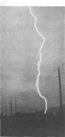
Lightening
Finally, a thunderstorm wouldn't be a thunderstorm without lightening. It starts to be produced after a cloud goes above the freezing level and electrical charges begin to develop inside the cloud.
The process of charge separation still puzzles scientists. It may involve millions of collisions among ice crystals and large ice particles. The University Corporation for Atmospheric Research reports that one
July/August 1997 /47
|
Long-term statistics show lightening kills |
theory postulates larger, and thus heavier, particles carry a negative charge as they sift to the cloud base, while the smaller, lighter particles, remain positively charged at the top. According to the UCAR, another theory holds that updrafts carry positive charges near the ground upward, while downdrafts carry negative charges from the upper air downward. In any event, at some point the attracting force between positive and negative charges is simply too great and electrons flow within a cloud, or to another cloud, or to the ground. The resulting lightening releases the electrical energy accumulated in the clouds. As the super-heated air around the lightening races away from the scene faster than the speed of sound, it produces thunder. Cloud-to-ground lightening poses a significant risk to people. According to NOAA, lightening causes about 100 deaths nationwide annually, more than tornadoes and hurricanes combined. Long-term statistics, based on annual Illinois Emergency Management Agency reports that hundreds more are injured. Even if it isn't raining, if you can hear thunder, you are probably close enough to a storm to be struck by lightening. If caught outdoors and you feel tingling or if your hair stands on end, squat low to the ground with your head between your knees. Under no circumstances should you lie flat on the ground. Without dismissing the potential thunderstorms have for being dangerous, Changnon believes an understanding of their functions and dynamics will allow people to see storm clouds in a different light. "Yes, lightening can be dangerous, and hail is a 'bad guy,' doing damage to my house, my tree, my corn plant," Changnon says. "And in the spring, heavy rainfall rates produce most of Illinois' erosion." "But nothing's nicer on a hot summer afternoon than to feel the cool blast from a front coming in, and to watch the clouds roll by." |
ANNE MUELLER
is a staff writer for Outdoor Illinois, a publication of the Deportment
of Natural Resources. Reprinted from the July 1997 Outdoorillinois.
48/ Illinois Parks and Recreation
OUR NATURAL RESOURCES NEWS BRIEFS
Free DNR Fishing Program Available to Park and Recreation Agencies
"There's a whole lot offish splashing at the surface down at the pond... why don't we go down and try to catch 'em?" one youth asks another.
"We've got no fishing gear! We'd be wasting our time."
Recreation supervisors, park district officials or perhaps as parents, you may have heard similar conversations among young constituents. Or, maybe you've seen youths using broken fishing poles, sticks with string tied to the tips, malfunctioning reels, no reels, or any other means children will think of and use in their urban environment to "catch a fish!"
Catching a fish is magic for any child, yet not everyone is lucky enough to experience the wonder of catching a fish. Well, that is changing! The Illinois Department of Natural Resources is now provides a program aptly called the "Access to Fishing Program," or what has been termed a "leaner rod and reel program."
What's DNR's motive for offering the free program? It's very simple: to get people from backgrounds rich and poor alike to experience fishing. Its an alternative to television, computer games, and BOREDOM, and the resulting problems with drugs, alcohol and gangs. It gives our future (our children) something to do!
Fact: The average fishing combo rod, reel and accessories cost between $20 and $30 for good, basic, entry-level equipment. Parents worry that the costs will add up to $90 for three kids, and what if they don't like it?
But what if they do? How are we going to handle this demand?" The Illinois Department of Natural Resources Access to Fishing Program has the answer! Here is how it works.
|
|
Approximately 30 rods and reels are loaned to a local park district, nature center, library or community service group. The rods and reels are loaned, along with terminal tackle (bobbers, sinkers, hooks) and instructional and informational publications about "How to Fish" and "Fishing." Each lending organization has determined its own procedure for loaning the rods, reels and tackle, and what parameters will be in place for their return (length of time, form of I.D. of the borrowers-such as photocopies of borrowing adult supervisors drivers license, perhaps requiring a deposit to be returned when the fishing gear is returned, etc.). |
The fishing equipment is maintained by the lending agency, along with the cooperation of a local tackle store or bait shop, sportsmen's club, or the agency's own staff. Fishing equipment, terminal tackle and literature is replaced as needed by contacting personnel at the Illinois Department of Natural Resources' Regional Urban Fishing Program.
If you have questions regarding the feasibility of adding this program to your park district or community services, call Community Family Services in Western Springs or the Fox Valley Park District to hear how well this program serves them as a community service, and how fishing as a sport is something everyone can enjoy and participate in. It can bring family members together for outdoor recreation with everyone participating at their own level of expertise.
The best part of this program is that it is free. The only requirement that the Illinois Department of Natural Resources makes is that you promote it, telling everyone about it and help with getting the message to the public.
If your park district or community service group is interested in adding this program, please call your Regional Urban Fishing Program coordinator listed below.
Region I (NW Illinois) - Karen Anderson............................ 815.625.2968
Region II (NE Illinois) - Rol Steinhauser............................. 847.294.4132
Region II (Chicago) - Brenda Harris ................................... 847.294.4137
Region III (SE Illinois) - Donald Dufford ........................... 217.333.5773
Region IV (SW Illinois) & V (S.Illinois) -John Martin....... 618.462.1181
Article by Rol Steinhouser, DNR's Urban Fishing Program coordinator for Region II, Northeast Illinois.
|
The Cicadas Are Coming! Don't look now, but the brood is coming! Periodical cicadas with a 17-year life cycle are emerging, right on schedule, in sections of central Illinois this summer. "Brood III of 17-year cicadas, which last emerged in 1980, is back in a large section of Iowa, parts of northern Missouri and portions of central Illinois," says Illinois Natural History Survey entomologist Dr. Christopher Dietrich. Entomologists aren't sure what prompts periodical cicadas to emerge after years of underground feeding and growth. In the spring of their 17th year, weeks before they emerge, cicadas build tunnels from their burrows. Members of the brood can be expected to emerge simultaneously. The cicadas are expected to be concentrated in Brown, Fulton, Henderson, Knox, McDonough, Schuyler and Warren counties with possible occurrences in Champaign, DeWitt and Piatt. "There are 12 different broods of 17-year cicadas, each of which emerges during a different year and occupies a different geographical area," says Dietrich. Other broods of 17-yeas periodical cicadas are expected to emerge in extreme eastern Illinois in 2004 and in northern Illinois in 2007. A brood of 13-year periodical cicadas is expected to emerge in central and southern Illinois in 1998. |
July/August 1997 /49