|
Home | Search | Browse | About IPO | Staff | Links |
|
Home | Search | Browse | About IPO | Staff | Links |
|
ILLINOIS HISTORY PRIMER
A Note on the Boundaries of Illinois Those who regularly teach and study the early history of Illinois will know everything in this sketch and much beside. We present this for those readers who have not studied the origins of our state and may be interested to know when and why we acquired our familiar geographical boundaries. Before the English came to the Illinois Country, the three rivers and Great Lake that make up most of our boundaries were not frontiers but, for Native Americans and early European explorers and settlers alike, the main highways. Thus French Illinois expanded on both sides of the Mississippi and Wabash rivers, and even up the Missouri and Ohio. Politically, the Illinois Country, including much of today's state of Missouri, belonged to the French province of Upper Louisiana. Only after defeat in the French and Indian War did the French sign a treaty (in Paris, France, 1763) which designated the Mississippi River as a dividing rather than a uniting stream. The French settlers on the west bank now honored the King of Spain as their ruler, while those on the east either pledged their loyalty to George III of England or gave up their lands and crossed the river. The Mississippi River has remained the western boundary of Illinois since. There was still no such thing as a province, territory, or state of Illinois. The British hardly had time to organize their vast Trans-Appalachian domain before losing it in the War for American Independence. Another Treaty of Paris (1783) ceded the Illinois Country to the United States. Virginia, by far the largest and most populous of our original thirteen states, claimed the Illinois Country and much else besides, on the basis of its original, seventeenth-century charter. To this was added the right of conquest based on the taking of Vincennes and Kaskaskia by George Rogers dark and his tiny army from Virginia. Virginia graciously ceded Illinois and the greater Northwest Territory of which it was a part to the United States in 1784. In that same year, Thomas Jefferson, once again representing Virginia in the Continental Congress, drew up the first of three Ordinances which were blue
28¦ ILLINOIS HERITAGE
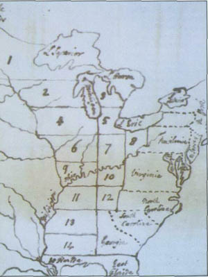
prints for the development of territories and states in the American West. Jefferson soon left for France, where he later heard that the Continental Congress extensively revised his work in the Land Ordinance of 1785, which set out rules for surveying the land prior to sale in the area now occupied by the states of Ohio, Indiana, Illinois, Michigan, Wisconsin, and that part of Minnesota east of the Mississippi River. This was the then new Northwest Territory. Congress followed two years later (during the same summer which saw the writing of the new United States Constitution) with the more famous Northwest Ordinance of 1787. It repealed Jefferson's principle that all U.S. territories should be permitted to enter the union as equal states on acquiring sufficient population and adopting a republican government. Believing that participatory democracy required small units of government, Jefferson sketched in three states for the territory now occupied by Illinois, and assigned both Indian and Greek names to them: Northern Illinois would be Assenisipia; Central Illinois, Illinoia; and Southern Illinois, Polypotamia. The last honored the merging of great rivers. However, the Northwest Ordinance decreed only three to five states for the entire Territory.
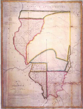
Illinois was nominally part of the Northwest Territory from 1788 onward, though its government, under General Arthur St. Clair, barely touched the French inhabitants who remained and the early English settlers who pioneered it. The year 1800 brought a new and somewhat more vigorous government under the young Virginia frontiersman, William Henry Harrison, who governed Indiana Territory. In 1809, however, the citizens of Illinois successfully petitioned Congress for their own Territorial Government, and it was then that the Wabash River and a north-south line connecting it with Lake Michigan became the eastern boundary of Illinois. When Illinois petitioned for statehood in 1818, Congress originally approved a northern boundary which extended westward to the Mississippi the line separating Indiana, admitted as a state in 1816, from Michigan Territory. Thanks to the successful lobbying of our Territory's representative, Nathaniel Pope, Congress accepted an amendment which raised the northern boundary forty-one miles. With the passage of that act and its signing by President James Monroe on December 3, 1818, Illinois became an equal state in the Union with the boundaries which have remained until the present. Had our enabling law not been amended, the valuable lead mines of Galena, the city of Rockford, and the extremely valuable real estate around Fort Dearborn, later Chicago, would have eventually become part of Wisconsin. Our northern neighbor would surely have become the richest state in the Midwest. Illinois owes much to the foresight of Delegate Pope. We remember him and his deed through the naming of Pope County in Southern Illinois.
|
|
|