 |
Home | Search | Browse | About IPO | Staff | Links |
|
Home | Search | Browse | About IPO | Staff | Links |
|
Bridge Over Scenic Water BY LIZ PENSONEAU AND WALT ZYZNIEUSKI
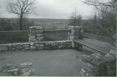
Travelers heading west on I-72 toward the historic river city of Quincy have a treat awaiting them when they exit the interstate to check out Fall Creek Rest Area, a 223-acre scenic parcel managed by the Department of Natural Resources. Although I-72 affords travelers a clear view of the majestic bluff line nearby, a visit to Fall Creek is a must to catch a glimpse of the Mississippi River valley and flood plain from the site's scenic overlook and to gain an appreciation of the area's true beauty. It's fun to imagine what it must have been like standing on the bluff at Fall Creek thousands of years ago looking southwest toward Missouri. It would have been a time when glacial meltwaters lapped at the base of the bluffs, swelling the Mississippi River to a width of 6 miles. Countless Native Americans
February 2000
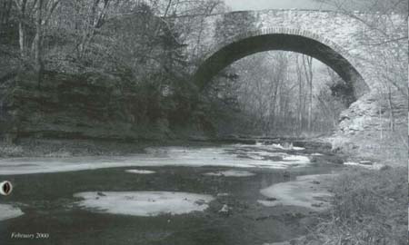
and early settlers probably stood there as hawks soared gracefully over their heads. Here early settlers discovered the rich fertile flood plain grounds for farming, and the potential for transporting goods to and from various river ports. An abundant supply of limestone was available for began to grow. However, the rocky gorge of Fall Creek put local farmers and their cargos at risk they tried to ford the creek with their marketable wares on their way to steamboats ana trains at Quincy and Hannibal. Mo. The solution as Fall Creek's stone masoit Joseph Elliot, with the help of his brother-in-law. James Mann. It was made from limestonf found in the area and constructed for a totat cost of $1032. Completed
12 OutdoorIllinois
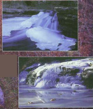
Frozen ice forms beautiful
James and mary Schnelker of Hannibal hours exploring Fall Creek during their first visit to the site in only six months, it served area farmers for nearly a century , as they used the single-lane bridge to transport their goods to the market-place. The bridgeclosed in 1949 after a new two-lane bridge was to replace it. In 1996 , following nomination by DNR , the bridge was replaced on the National Register of Historic Places. Principal ownership of the Fall Creek property rested with
Febraury 2000 13
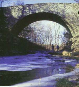
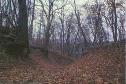
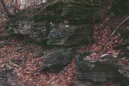
Henry Seymour family until 1980, when it was purchased by the state. Seymour had opened the land around the bridge to the public from 1924 to 1969, even adding picnic tables and grills for use by those crossing the bridge. Today, there are 16 picnic tables, a drinking fountain, toilet facilities, playground equipment and ample parking at the site. Two one-mile trails can also be enjoyed. One starts near the entrance gate and winds through the heavily wooded slopes to an overlook, returning hikers via an abandoned road. Be forewarned that an old pair of sneakers or waterproof boots is a good accessory for taking the second trail to the bridge and upper falls. Hikers will splash through the gorge, probably developing a quick appreciation for the clear, rock-lined stream where boots can actually be seen touching the bottom. There's a wooden observation deck over the creek, a small fishing pool and the largest of two waterfalls. At three feet or so, the waterfall is impressive for Illinois, especially with the limestone gorge as a backdrop. Explorers will get off the trail at the side of the waterfall, onto the rocks and splash their way through the gorge. As the water can be seasonally high and the rocks slippery, hikers should watch their footing and hang on to young children while making their way into the gorge. As they round the bend, the walls of history will unfold in front of their eyes. A limestone wall, at least 40 or so feet high and millions of year old, awaits them. Again, it's fun to imagine Native Americans going after game in the area, playing and fishing in the creek, and sitting on a rock ledge working on their stone tools. Around the next scenic bend, and under the current roadway, is Fall Creek Stone Arch Bridge. Here visitors are sure to marvel at the engineering and craftsmanship that went into building this bridge. Remarkably well preserved, it stands 33 feet above the creek bed, and the design of the arch is impressive. No longer used for vehicular traffic, it serves as a pedestrian walkway. From the historic bridge, a service road and trail may be taken to the second waterfall area, with a return loop back to the bridge. For safety reasons, use extreme caution while hiking atop the bridge, near the edge of bluffs and through the gorge. To reach the scenic overlook, travelers may want to take their vehicles or else hike from the parking lot. Either way, the overlook will not be a disappointment. It affords a great view of the river valley and the relief seen there proves that not all of Illinois is flat. Directions to Fall Creek Rest Area: Exit 1-72 at Illinois 57 (Exit 2). The site is located a mile northeast of the junction of Illinois Route 57 and the Fall Creek-Payson Road. For additional information contact: Siloam Springs State Park, RR # 1, Box 204, Clayton, Ill. 62324, or phone (217) 894-6205.
14 OutdoorIllinois |
|
|