"The rivers they boiled like a pot over coals,
and the mortals fell prostrate, and prayed for their souls"
... Henry Schoolcraft, 1812
If you were to ask typical Midwesterners what they know about earthquakes in the United States, they
may start talking about events in California or Alaska. Many of them would be surprised to find out that they
themselves live in a major seismic zone. They would probably also be shocked to find out how strong the quakes can be and how unprepared most of us are to deal with them.
In the small hours of the morning on December 16,1811 the citizens of Boston, Mass. were awakened by the sound of rattling glass and phantom church bells. Though they would not know it for some time, the earthquake that they assumed to be local, because of its intensity, had actually originated more than a thousand miles away. At a little after 2 a.m. in the remote wilderness along the St. Francis River in Arkansas, the earth's crust
fractured deep underground. The shock waves that raced away from the epicenter could be felt from the Rocky Mountains all the way to the eastern seaboard of Canada. This was the first in a series of earthquakes that would traumatize the inhabitants of the Mississippi and Ohio valleys for the next four months. The more than 1,200
individual quakes and aftershocks that followed, three of which were in excess of eight on the Richter scale,
would be known collectively as the Great New Madrid earthquake.
Situated on a bend in the Mississippi River, the town of New Madrid, Mo. was the closest established settlement to the
epicenters. Prior to the quakes of 1811-1812 New Madrid was well on its way to being a major hub of commerce along the Mississippi River. It was a good place for river traffic to port just before or after traversing a difficult section of the
river north of Memphis, Tenn. The town had a population of about 400 residents at the time of the first quake. By the time the seismic activity had stopped, the town's elevation had dropped 13 feet. All the buildings in the town were
severely damaged or destroyed and most of its citizens fled the area, never to return.
The quakes came in rapid succession, the first one, a magnitude 8.6, was on December 16, 1811 near Marktree, Ark. The second event, a magnitude 8.4, was on January 23, 1812 near Caruthersville, Mo. The last and most violent of the three, a magnitude 8.8, occurred at 4 a.m. on February 7 of the same year a few miles south of New Madrid. The
timing of the quakes was so close together that in March of 1812 the aftershocks of all three overlapped.
Soon after the first shocks, stories began pouring out of the region painting a picture of utter devastation. From St. Louis, Mo. to Natchez, Miss. riverboat pilots reported that the river in places had been altered to the point that it was
unrecognizable and barely navigable. One boat captain who had stopped for the evening found the next morning that the sizable island he had been anchored to the night
10 ILLINOIS COUNTRY LIVING AUGUST 2001
before had vanished without a trace. Entire groves of trees had slid into the water creating half submerged forests. Not only were there trees in the water from the crumbling of the banks, but the agitation of the riverbed had forced up the trunks of trees that had lain on the bottom of the river for centuries. Channels in the river that were once open were now choked with ghostly ebony root forests.
Eyewitnesses reported the Mississippi River flowed backwards for a period of time after the quake. This account is only partially true. Only a small section of the river was affected this way. The backward flow of the river was due to the lifting up of a region called the Tiptonville Dome near Reelfoot Lake in Kentucky. North of this area the river would have rolled back on itself for a brief time and a tidal surge would have gone down stream as the river tried to adjust to
the changes in elevation. One of these surges pushed boats at anchor as much as a quarter mile inland along adjoining creeks.
Many of those who had experienced the quake reported a loud thunderous noise. They also said that after the shock-wave had passed under their feet, it left a hazy vapor in the air that smelled strongly of sulfur. This caused many to hear that a volcanic eruption was eminent. A few stories were passed around at the time of a volcano erupting in Arkansas. This turned out to be just a tall tale. Although volcanoes can cause earthquakes, earthquakes can happen without volcanic activity. The best guess as to what was producing the "sulfur" smell is that the shaking caused the release of trapped gas from decomposing organic matter underground. As for the noise, according to Harvey Hansen, a geophysicist at Southern Illinois University, "It is unlikely that they actually heard the earthquake itself." The sound that is produced by an earthquake is too low of a frequency for human perception. The sounds that witnesses heard were, in most cases, caused by the shaking of the structures they were in or near.
The sounds that witnesses heard during the earthquake were, in most cases, caused by the shaking of the structures they were in or near.
|
Some of the more bizarre events associated with the quake can be attributed to a process called liquefaction. Liquefaction occurs in areas that have a lot of moisture in the ground, such as aquifers. As the ground shakes it tends to squeeze the water out of the soil, in some cases causing the surface of the ground to react like quicksand.
There were reports of some buildings sinking into the ground up to their rooflines.
Another product of the liquefaction process is called sand boils. Witnesses reported seeing geysers of sand and water shooting out of the ground, in some cases as high as 30 feet. Just outside of the present-day New Madrid, you can
still see large shadowy circles where the sand bubbled up out of the ground. They were described immediately after the quake as being snow white and having a depression at their center. Some of these were even said to have thrown
out chunks of coal-like material.
Over a century and a half after the cataclysmic events of 1811-1812, scientists have started to unravel the mechanics of the great quake. The movement of the river over the last 190 years has erased much of the physical effects of the quake. The deceptively flat region that stretches south from the boot heel of Missouri to New Orleans disguises a maze of geological features. Over the eons the ancient geologic vallys have filled in with sediment from the erosion of the Ozark and Appalachian Mountains and glacial runoff from the numerous ice ages.
The Mississippi River runs through what geologists refer to as a failed rift. Rifts form when large detachment faults attempt to break continents into two separate landmasses. The land between them becomes severely fractured
and sinks into a rift valley. "More than 500 million years ago, the continent of North America tried to pull itself apart," says Henson. This process was similar to rifting happening now in the Middle East. The continent of Africa and the Arabian pennisula are moving away
AUGUST 2001 ILLINOIS COUNTRY LIVING 11
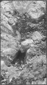
This fault called the Lincoln anticline is visible evidence of seismic activity in Illinois. It is located in Pere Marquette state park near Alton.
|
from each other resulting in the creation of the Red Sea. Had the rifting continued here we might be building much bigger bridges to get from Illinois to Missouri.
One misconception about the New Madrid seismic zone is that it is one big fault system. We are just now finding out how complex the geology under all those layers of sediment is. Current assessments indicate several major faults in this area. They are the Reelfoot Rift in the Missouri bootheel and western Kentucky area, one in the Wabash valley region, and one in southern Illinois known as the Commerce Lineament. Each of these areas could have the potential to produce large earthquakes. In short, what we don't know about the ground under our feet could, and hopefully will
someday, fill volumes.
It is uncertain at this time whether this region is becoming more or less active. Some think we have entered a quiet phase of a quake cycle, while others say the 1811-12 quakes could be the last major event this area will see. The
number of perceptible earthquakes in the New Madrid Seismic Zone, which covers an area from Arkansas to the Illinois-Indiana border, are few and far between but seismographs record an average of two or three low level quakes a week.
Predicting exactly when and where the next quake will occur is impossiable. There are some geological patterns that we can draw conclusions from, but when it comes to earthquakes, history does not always repeat itself. The earliest
historical record of seismic activity in the United States was in 1699. When you consider that the New Madrid area probably averages a great quake every 500 to 700 years, we don't have a lot of historical evidence to work with.
We know large earthquakes have happened in the past and will happen again in the future, so the question to ask is what can we do to prepare for them?
The three things that determine the effects of an earthquake are soil depth, soil composition, and proximity to the epicenter. It goes without saying that the closer you are to a fault rupture, the more you will feel it. However, it's what is directly beneath your feet that will have the most impact on you and your property. The majority of Illinois, from Chicago to Carbondale is covered by glacial sediment. The depth of this soil varies, but averages 25 feet in depth.
The more soil you have between the bedrock and the surface of the ground, the more damage you are likely to see in a given area. The looser soil layers have the effect of amplifying the vibrations from a quake. When you add water to the
soil, the liquefaction process can only make things worse.
If a big quake happens along the Mississippi River during the spring run-off, the damage to the levee system could aggravate an already bad situation. Large areas of the Mississippi valley could be flooded, disrupting even more
of the area's infrastructure.
Because they are underground, some utilities such as water mains and gas lines will fare the worst. The Federal Emergency Management Agency (FEMA) estimates that sizable percentage of our under-ground utilities could be damaged in a major seismic event.
The country is divided into seismic zones with five levels of intensity, the fifth level being the most active. The southern-most parts of Illinois are rated as a zone three. Southern Illinois Power Cooperative's (SIPC) generating
station at Lake of Egypt sits on the border between zones two and three. The plant is built on bedrock to help stabilize it against ground movement. Jarrel Graham, the transmission department manager at SIPC, says that steps have been taken to minimize the effects of seismic activity on the co-op's other facilities. Transmission lines are relatively
unaffected due to the flexibility of the poles and towers that carry them. However, substations and other fixed structures are vulnerable. Older substations' foundations have been expanded to stabilize them against ground
movement. Transformers have been anchored to prevent them from toppling over. All new substations are built to current earthquake standards, and new types of materials are being used in the manufacture of transformers. Graham states that new polymer insulators on transformers are much more flexible than the older ceramic type, and
therefore less likely to break under stress.
12 ILLINOIS COUNTRY LIVING AUGUST 2001
|
The Richter Scale
and what it all means
The Richter scale used to define the strength of an earthquake was created by Charles Richter and Beno Gutenberg in 1935. Each whole number increase on the scale is ten times stronger than the previous number. For example an earthquake rated as a five on the Richter scale would be ten times stronger than a four and a six would be 100
times more powerful.
1-4 Quakes in the first four levels are mild. Most of these would go unnoticed.
5 Most people will notice a five. It may knock dishes off shelves and rattle windows but cause no real
damage.
6 Everyone will feel a six. Some items on shelves will fall off. Damage may occur to chimneys and plate
glass windows. Some plaster walls may cracks.
7 A seven will get everyone's attention. Even people driving cars will notice. Chimneys on older houses may collapse. Most loose items on shelves will fall to the floor.
8 The shaking may cause some people to lose their balance while standing. Driving a car will become difficult. Walls crack and plumbing may leak or break. Shelves and cabinets tip over.
9 The shaking is intense and it becomes very difficult to stand. Major damage occurs to many structures. Roadways may buckle and some bridges may collapse.
10 These are very rare and incredibly intense earthquakes. People are thrown to the ground and can't get up. Extreme vertical shaking causes items to bounce along the ground. Almost all structures are destroyed or sustain severe damaged.
|
There are things that you can do at home to help diminish the effects of an earthquake. Many are the same things you would do to prepare for any other emergency, such as having a portable radio, batteries and bottled water available. There are a few measures specific to earthquakes that you should be aware of.
First, you should secure items that might fall during ground movement. Water heaters and bookshelves are probably the most notable items. Use a metal strip called "plumber's tape" to fasten your water heater to a stud in the wall. For bookshelves, you can use a heavy gauge fishing line or just screw them to the wall.
Another thing you should know is the location of all your utility shut-offs. Pipes could rupture during seismic events, and being able to shut them off quickly will prevent flood or fire damage.
One very important thing we tend to overlook is insurance. Homeowner policies don't cover earthquake damage unless you specifically ask for it. Considering the consequences, it is a relatively cheap investment. Most insurance
companies charge about the same for coverage. Typically it is $3 per thousand dollars of assessed value of your home, $6 if your home is made of brick.
The general public was made aware of the potential threat that the New Madrid siesmic zone presents in 1990. Climatologist, Iben Browning falesly predicted an earthquake in the region based on the effect of an abnormally close
lunar orbit. A group of scientists did a study soon after the scare of 1990 and found that there was no evidence that the close proximity of the moon had any impact on the geological features of the midwest region. Browning claimed to have made an accurate prediction of an earthquake in California a few years earlier. That prediction could be
attributed to the concept that if you throw enough stuff at a wall, something will stick. Reporters, always on the lookout for the next big scoop, ran with the story without checking the facts. The widespread media coverage sent a wave of panic through the region. Parents concerned about their children's safety caused schools to close due to a lack of attendance. Emergency services were mobilized in Missouri and Arkansas and convoys of news trucks descended
on the tiny town of New Madrid turning it into a media zoo. December 3 came and went without a tremor. Though it was later to be dubbed the "Great Non-Event" it did make people aware of the potential risk of a large-scale
earthquake in the midwest. It also prompted federal and state agencies to look into the issue of earthquake
preparedness in the region.
Because we don't have an arrival schedule for the next "big one," it is safe to say we should always be prepared. You may not be able to plan for earthquakes, but you can plan on them. In all likelihood we can expect to see a magnitude 6 to 6.5 quake in the next 100 years.
The one prediction we can make about earthquakes is that for the foreseeable future they will continue to be unpredictable. Being prepared for earthquakes means you will also be prepared for more common disasters such as floods, tornadoes and winter storms.
For more information about earthqakes try visiting one of these websites.
Contact Harvey Henson at:
www.science.siu.edti/geology
Central U.S. Earthquake
Consortium:
www.cusec.org
Illinois Country Living:
www.aiec.org
AUGUST 2001 ILLINOIS COUNTRY LIVING 13