|
Home | Search | Browse | About IPO | Staff | Links |
|
Home | Search | Browse | About IPO | Staff | Links |
|
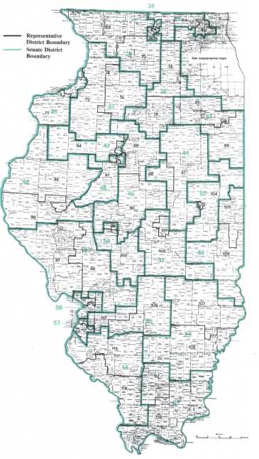
By CHARLES N. WHEELER III Restricting '81 The decennial drama of redrawing legislative districts was further complicated in Illinois by the 1980 passage of the Cutback Amendment. Political futures in the balance, Democrats and Republicans feverishly attempted to dissect Illinois to their own best advantage. The drama opened in the General Assembly; the middle acts took place at the Legislative Redistricting Commission; and the final act was in the courtroom before a three-judge federal panel, reaching what appears to be a strictly Democratic denouement IN POLITICS, like meteorology, forecasting can be a risky business. Just ask the Old Farmers Almanac, which predicted the winter of 1981-82 here would be a mild one, or the Illinois political pundits who figured Republicans couldn't lose in the decennial exercise in partisan cartography known as legislative redistricting. The shivering Midwesterner battling record low temperatures was no more chagrined than GOP legislative leaders when the mapmaking was finished. And Democrats were as happy as a junior executive just transferred to his company's branch office in the Bahamas. The Democrats' elation, and the Republicans' dismay, are the two faces of Redistricting '81, a nine-month struggle to set boundaries for Illinois Senate and House districts for the next decade. The average voter, of course, might wonder why he should be concerned at all about this World Series of politics. After all, isn't it simply one bunch of politicians trying to do in another? Certainly it is. But the outcome of the partisan battle is sure to have considerable effect on Ulinoisans' daily lives. Each new map has sliced the political pie among the state s various sections. These decisions, in turn, color many of the most important issues before the General Assembly, helping to determine how legislators will react to a wide variety of topics on which the major parties or sectional interests strongly identify with opposing views. Most Republican legislators, for example would solve the state's chronic underfunding of its unemployment insurance program quite differently than most of their Democratic colleagues. And the state's transportation crisis revolves around mass transit for most Chicago lawmakers while it means highways to downstaters. So, whether or not they realize it, the stakes in redistricting are high for all II-linoisans, not just the politicians. The big winners in 1981 were the Democrats, whose Cinderella-like fortune left Republicans looking shell-shocked and feeling snakebitten. Early in 1981, as redistricting began, GOP leaders believed, and most political experts agreed, that Republicans were sitting pretty. The areas of the state which showed the most growth during the last decade were Chicago's mushrooming suburbs, traditionally GOP bastions of strength. Conversely, the population loss in the city, the Democrats' chief stronghold, was among the most severe in Illinois, and the once-potent Democratic machine had merely sputtered in recent elections. In addition, Republicans had one of their own in the governor's chair, ready to sign any Republican redistricting plan or to veto any Democratic proposal. The GOP controlled the House, 91-86, and needed to entice just one Democratic crossover in the Senate for the 30 votes required to pass a Republican map there. When voters went to the polls on March 16, however, there were Democratic-drawn boundaries delineating their legislative districts. Through a combination of luck, hard work, political acumen, shrewd legal tactics and a bit of old-fashioned head-knocking, Democratic leaders were able to craft a map Republicans fear will make them permanent second-class citizens in the legislature. The Democrats' partisan advantage was built into a map approved in October by the Legislative Redistricting Commission after Democrats, through the luck of the draw, gained a one-vote majority on the panel. The Democratic triumph was assured in January by the ruling of a three-judge federal court panel in a GOP-financed challenge to that map brought by a coalition of blacks, Hispanics and Republicans. Although the federal judges ordered more black and Hispanic districts added to the October plan and tidied up some suburban lines, they did not disturb its Democratic flavor, nor frustrate the party's aims. What then, does the new map look like? And what are its implications for Illinois politics for the next decade? The 1981 map When Democrats used their 5-4 margin on the Legislative Redistricting Commission to approve the map which became the blueprint tor the federal court plan, unhappy Republicans were imaginative and colorful in disparaging its boundaries. "It's a Chinese puzzle," groused Senate Republican Leader James "Pate" Philip of Elmhurst, while Gov. James R. Thompson likened its suburban districts to "a next of salamanders." But former Democratic Gov. Samuel H. Shapiro, who cast the tie-breaking vote on the panel, said the map met the constitutional requirements of compactness, contiguity and population equality. ________________________________________The big winners in 1981 The chief guideline for the map-makers, added the commission chairman, Sen. James H. Donnewald (D., Breese), was the one-man, one-vote principle. "Everything else was subservient." In fact, the redistricting plan approved by the court and based on the commission map falls well within acceptable population variances, according to computer analyses by the 10/April 1982/Illinois Issues consulting firm which aided Democrats in its preparation and legal defense. None of the 59 Senate districts and only one of the 118 House districts miss their target populations by more than 1 percent. Even while adhering scrupulously to population equality, Democrats were able to craft districts to the advantage of their party and of its big-city base that also could pass legal muster. Again, Republicans were quick to complain when the Democrats' skill became apparent. "This is a plan to favor and entrench for the next 10 years one political party," declared House Majority Leader Arthur A. Telcser (R., Chicago), vice chairman of there districting panel, when the fateful vote was taken. In the worst imaginable year for Democrats, Philip predicted, the party would elect at least 31 senators and at least 61 representatives, enough to control both legislative chambers. Brushing aside the GOP cries of "foul," Shapiro argued that tacking partisan labels on the new districts was difficult, because of the decline in straight party votes and the influence of such factors as candidate personality, campaign style and state and national issues. There are valid points on both sides of the debate. The 1971 map, for example, was touted by former House Speaker W. Robert Blair, a Park Forest Republican, as one that would assure GOP control of the legislature in normal years. During a decade under the 1971 map, however, Democrats fared much better than Republicans. In the Senate, for example, 25 districts elected only Democrats, while Republicans did that well in only 23. Although the political fortunes shifted in the other 11, Democrats enjoyed Senate majorities for the last four of the five General Assemblies. In the House, Democrats elected two or more representatives each election in 24 districts, while Republicans dominated 19 districts and political control was shared in the other 16. As a result, Democrats held House majorities in three of the five legislative sessions during the map's lifetime. Nonetheless, how district lines are drawn is an important factor — in some cases the deciding factor in legislative races. For the partisan cartographer, mapmaking is simply an effort to tilt a particular district toward a particular party. And careful study suggests that, despite its apparent balance, the new map definitely leans Democratic.
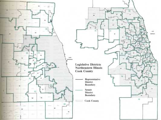
April 1982/Illinois Issues/11 According to a Democratic analysis based on past elections, the 59 Senate districts include 21 deemed "firm" Democratic, 25 "firm" and 3 "soft" Republican ones, and 10 "swing" districts, in which neither party enjoyed a decided advantage. But currently there are popular Democratic incumbents in six of the swing districts (42nd, 49th, 54th, 58th and 59th) and two of the nominally GOP Senate districts (35th and 43rd), and the Democratic mapmakers sought to protect them. Three other swing districts, two in suburban Cook County (26th and 39th) and one focused on blue-collar neighborhoods of Peoria and Tazewell counties (46th), also were carved to favor Democrats, and GOP territory was shaved from Senate districts around Rockford (34th), Rock Island (36th) and Springfield (50th). The 118 House districts include 39 firm and 5 soft Democratic, according to the same voting study, all but 10 of them dominated by Chicago. There are 41 firm and 9 soft Republican districts, while 24 are considered swing. Democratic strategists, however, are confident about the chances for party candidates in most of the swing districts as well in several of the nominally Republican districts. "If we can't win majorities with this map, we may as well consign ourselves to permanent minority status," observed one Democratic leader. Besides giving Democrats an apparent edge over Republicans in legislative elections for the next 10 years, the re-districting plan also is likely to strengthen Cook County Democrats' power in the legislature — despite Chicago's declining population. Although losing some 364,000 residents from 1970 to 1980, the city stands to yield control of only one Senate district, thanks to the map's overlapping of 10 districts into suburban territory. Each of the hybrid districts has enough city precincts to be rated firmly Democratic, and along with 9 other districts wholly in the city, should elect city-oriented Democrats in the future. In addition, Cook County Democrats are hopeful of picking up seats in two carefully drawn, all-suburban Senate districts, one northwest of Chicago (26th) and the other south of the city (39th). Thus, the map actually could lead to a net increase, to 21 from 20, in the number of Cook County Democratic senators, and the so-called "machine" delegation should continue to outnumber its independent and downstate partymates in the Senate by at least the same 2-1 margin it now enjoys. In the House, the map's impact within Democratic circles should be even more dramatic in the wake of the legislative "Cutback Amendment," clearly transferring the balance of power to the city from suburbia and downstate. Currently, a minority of House Democrats, 41 of 86, are from city-dominated districts, and suburbanites and downstaters make up the majority within the party caucus. Under the new map, though, election of 37 city-based representatives seems probable, well more than half the number needed for control of a House shrunken by one-third to 118 members, and certainly far more than the suburbs and downstate are likely to elect, even under the most favorable circumstances. The key to the city's anticipated hegemony among House Democrats, of course, is the map's creation of 21 city and 16 hybrid, city-suburban House districts, all of which are expected to elect city-oriented Democrats. If that occurs, Chicago Democrats will lose less than 10 percent — just 4 of 41 — of their current House seats, despite the one-third reduction in House size. By carving out seven winnable districts (27th, 51st, 52nd, 56th, 58th, 77th and 78th) in nominally Republican, suburban Cook County, the Democrats are facing a likely loss there of only five seats because of the cutback. Thus, if the Democrats' strategy succeeds, only 9 of the 53 House seats currently held by Cook County Democrats will be eliminated by the cutback. Republicans, on the other hand, stand to lose 21 of their 36-seat Cook County delegation, including every Chicago Republican. With Chicago Democrats' enhanced clout in the party caucuses, predicted Telcser, the House majority leader, the city should be able to elect the Senate president and House speaker of it choice. "City Hall should be in a position to rule the General Assembly with an iron hand for the next decade," he lamented. Although the four Republican: members of the redistricting panel offered a map they claimed was more balanced, and a GOP-financed "non-partisan" map surfaced during the federal court challenge, GOP strategists admitted privately they would have tried just as hard to wipe out Democrats had they been drawing the lines. Under an intensely partisan Republican map, for example, Chicago probably would have received no more than the 15 Senate districts and 31 House districts warranted by its population, and several of the House districts would have been designed to safeguard incumbent Republicans. Most surburban and many downstate Democrats also would have been targeted for early retirement. But Republicans did not draw the map, and instead it is a host of GOP incumbents whose legislative careers are in jeopardy. As approved by the commission initially, for example, the redistricting plan threatened 14 of the 29 sitting GOP senators, either by placing them in Democratic-leaning districts or tossing several together in the same GOP district. Philip, the Senate GOP leader, was among the victims, as were his two assistant leaders, Sens. AldoAi DeAngelis of Olympia Fields and John E. Grotberg of St. Charles. In the House, the commission map similarly tossed GOP incumbents together in a number of solidly Republican areas, including one suburban district in which four GOP representatives were dumped. More than partisan orneriness was involved in the suburban scramble, however. Instead, the Democratic strategy was to fragment Republican power bases to weaken GOP suburban political organizations. DuPage County, the GOP heartland and Philip's home base, was shattered into seven Senate and 12 House districts, of which only one Senate and three House districts were wholly within the county. Similar fates were suffered by other GOP strongholds. Cook County's Cicero Township, for! example, with a population less than two-thirds of the number needed for an ideal House district, was split among four Senate and five House districts. 12/April 1982/Illinois Issues
Although the final version of the map included court-ordered changes in suburbia that disentangled the GOP leaders and most of the other scrambled Republican senators (giving each a district of his own), the GOP bastions were not glued back together. So DuPage County remains traversed by seven Senate and 11 House districts, and Cicero is still fragmented among four Senate and five House districts, its northern half in a Chicago-based, 74 percent black Senate district. While the federal court declined to dilute the map's strong Democratic flavor, the judges did order the creation of additional minority districts which should increase representation for blacks, who comprise about 15 percent of the state's population, and should permit the election of Illinois' first Hispanic legislator. In the Chicago area, the map provides 6 Senate districts and 13 House districts in which 66 percent or more of the residents are black, according to a demographic breakdown prepared by Democratic computer analysts. Five of the Senate districts are drawn on the South Side, including the 17th that sprawls into some south suburban territory. The other black Senate district, the 9th on the city's West Side, also overlaps into the suburbs, taking in parts of Oak Park and Cicero. Of Chicago's 13 black House districts, 9 are on the South Side, including the 33rd and 34th that overlap into the south suburbs. Three of the remaining four, all on the West Side (15, 17 and 18), also contain suburban territory. In addition, there is a black majority in downstate House District 113 centered in East St. Louis. Initially, the commission plan included 5 Chicago-based Senate districts with populations 80 percent or more black, 12 Chicago-based House districts that were at least 66 percent black, and the black East St. Louis district. Although the final map provides black majorities in one more Senate district and in another House district, it does not satisfy the goal of proportionate representation sought by some Chicago blacks. Nonetheless, it seems certain at least to maintain current black numbers in the Senate and to all but insulate black strength in the House from the Cutback. Currently, there are six black senators, all of them Democrats. Five are from Chicago and one, Sen. Kenneth Hall, resides in East St. Louis. Blacks seem certain to be elected in five of the six black majority districts the map carves out in Chicago, while political analysts expect the current white incumbent to retain his seat in the sixth, the 18th District located on the city's far South Side. In the House, there are now 15 blacks, including 13 Chicago Democrats, one Chicago Republican, and an East St. Louis Democrat. Under a strict mathematical application of the House cutback formula, black numbers there would be reduced to 10, a loss of five seats. By providing the 13 Chicago-based and the one East St. Louis House districts with solid black majorities, however, the map likely will result in the loss of only a single April 1982/Illinois Issues/13 black seat, according to Democratic analysts. If that prediction is borne out in the general election, blacks will make up about 11.9 percent of the membership of the new slimmed-down, 118-member House, a 40 percent increase from their current 8.5 percent share of 177 House seats. The new redistricting, with the cooperation of Chicago organization Democrats, also likely will provide an ethnic voice for the almost 636,000 Hispanics living in Illinois. The map delineates one Hispanic majority Senate district (5th) in the largely Puerto Rican Humboldt Park and West Town neighborhoods on Chicago's Northwest Side. Its House components include the 9th District which is 63 percent Hispanic and the 10th in which Latins are just about half the population. Though most political analysts expect both the Senate and the two House districts to remain firmly under regular Democratic control, local ward committeemen have slated a Hispanic candidate who should become the first Latin elected to the General Assembly in state history. Hispanics form a 71 percent majority in the 20th House District on Chicago's Southwest Side, centered on the Mexican communities in Pilsen and Little Village. Here, too, a Latino's chance for election would be enhanced mightily by Democratic machine backing. In fashioning additional minority districts in Chicago, of course, the federal court did nothing to undermine the partisan advantage Democrats built into the new map. Whether white or black, Anglo or Hispanic, the city legislators aren't likely to be Republican. To appreciate the magnitude of the political upset achieved by the party and the city, and indeed, to sense the complexity of the redistricting struggle itself, it's probably best simply to follow the drama as it unfolded, with particular attention to the Democrats' part in the play. Demographic democracy The stage was set for Redistricting '81 by a pair of events that occurred the year before — the 1980 federal census and the Cutback Amendment, which reduced the membership of the House from 177 to 118 and established single-member representative districts. Both factors posed serious problems for Democrats and offered attractive possibilities to Republicans. The federal government's decennial nose-court showed the state's population to be slightly more than 11.4 million, an increase of about 308,000, or 2.8 percent, during the decade. But the growth was not uniform. For Chicago, whose 1980 population stood just over 3 million, the census documented a loss of some 365,000 residents, a 10.8 percent decline, during the '70s. During the same period, suburban Chicago population boomed by 13.6 percent to just over 4 million. In 1980, almost 492,000 more people lived in suburban Cook County and its five collar counties of Lake, McHenry, Kane, DuPage and Will than resided there 10 years earlier, according to the census. _____________________________ In the state's 96 other counties, the census documented downstate population at 4.3 million in 1980, an increase of about 180,000 persons, or 4.4 percent, during the decade. The political implications of these demographic changes were ominous for Democrats, rosy for Republicans. Under the U.S. Supreme Court's "one man, one vote" rulings, each of the state's 59 Senate districts needed 193,533 residents. For each of the 118 House districts, the target population was 96,767. In Chicago's case, its count of 3 million plus entitled it to 15!/2 Senate districts and 31 House districts. Since 1971, however, the city had controlled 20 legislative districts. Now it stood to lose at least four, perhaps five, of them. In the suburbs, a population of 4 million translated into 21 and a fraction Senate seats and 42 House seats. Under the old map, there were 17 districts based in suburbia. Downstate claimed the remaining 22 and a fraction Senate seats and 45 House seats, just about what the area had under the old map. Of course, the projected shift of five legislative districts from Chicago to the suburbs was based solely on arithmetic. In real life, political map-makers can avoid such a strict, mathematical slicing of the territorial pie in several ways. In 1970, for example, the city's population entitled it to just under 18 districts, but by stretching 9 city-based districts past the city limits to pick up almost 400,000 suburbanites, the 1971 mapmakers allowed the city and its Democratic organization to dominate two more districts that its population warranted. But the overlap technique has its limitations; put too many suburbanites in a hybrid district and they might elect a Republican or, even worse from the standpoint of Chicago regulars, an independent Democrat. From the 1980 census data, though, it was obvious the city's overlapping districts would have to sprawl even further into the suburbs if 20 districts were to be preserved. Including both city and suburba tory, the city's existing districts had a population of some 3.4 million. That represented a decline of almost 400,000 during the decade. To meet the population requirement for 20 districts, however, some 3.9 million residents were required. Thus city Democrats faced a dilemma, as they approached redistricting: swallow another half million suburbanities to keep 20 city-based districts, some of them shaky suburban hybrids that could go Republican, or bow to demographics and settle for a fewer | number of sure districts. Republicans, on the other hand, had every reason to believe demographics were on their side. The five collar counties, for example, were the fastest-growing portion of the state in the last decade, as population zoomed some 25 percent to 1.8 million. With the exception of a few pockets of Democratic strength in some of the industrial cities in the region, the collars are a GOP bastion. And in suburban Cook County, while some of the older, closer suburbs lost residents, population burgeoned in several areas 14/April 1982/Illinois Issues of considerable Republican strength, including the county's northwestern panhandle and its far southwestern flank. In fact, the toughest decision the census seemed to pose for Republican mapmakers was where to locate five new suburban districts. The Cutback Amendment, however, made redistric-ting tougher for both parties and carried particular peril for Democrats. Approved by some 68.7 percent of the voters in the 1980 general election, the amendment eliminated 59 House seats and eliminated the 110-year-old, uniquely Illinois system of cumulative voting. Because both Democrats and Republicans usually nominated only two candidates from each party for each district's three seats, both parties generally were assured of winning at least one spot in every district and maintaining their relative voting strength in the other's territory. The old system also made redis-tricting a simpler chore, most obviously because political cartographers needed to draw just 59, instead of 177, districts. In addition, the larger, multi-member districts made it easier to protect incumbents of both parties. A district could be given a distinct partisan flavor that would satisfy the majority party's two House incumbents without formally dividing the party's strength between them. And no artful gerrymandering was needed to protect the minority party incumbent, who usually depended instead on pockets of strength spread here and there throughout the district. With the constitutional change, however, no longer would a minority party representative be able to survive with the help of a few friends in hostile territory. And for 59, there could be no winnable district at all. Everyone agreed the change would eliminate completely Chicago Republicans. On a partisan basis, however, it seemed particularly threatening for Democrats, whose few power bases outside Chicago in most cases could be scattered easily over the largely Republican countryside of suburban and downstate Illinois. Nor was it only the rank-and-file legislator who was in jeopardy; five of the eight legislators in the House Republican leadership were elected from Democratic districts, while two of the seven Democratic leaders came from hostile territory. Besides forcing mapmakers to choose which 59 representatives to eliminate, the amendment also meant they would have to apportion good partisan territory among the survivors in 118 single-member House districts, each of which had to form one-half of a Senate district. It was against this backdrop that the General Assembly sought to redistrict itself in 1981. The legislative stage Complicating the redistricting task in 1981 was the partisan split in the legislature. Democrats controlled the Senate, 30-29, while Republicans were a 91-86 majority in the House. As the session opened, many politicians and pundits believed redistricting had moved from the merely difficult to the frankly impossible. Most of the experts expected the new boundaries to be drawn by the commission, following bipartisan agreement among legislative leaders, with Gov. Thompson and Chicago's Mayor Jane Byrne looking over their shoulders. Nevertheless, leaders of both parties forged gamely ahead, relying on a curious mixture of space-age computer technology and old-fashioned ward-heeler instinct to produce their maps. Republicans spent well into six figures for computer programming and demographic data to help them produce GOP-flavored maps. Though somewhat reluctant at first — preferring "gut feelings to computer printouts" in the words of one old-timer — Democrats, too, ultimately invested in sophisticated technology to craft their plans. In the crucial final stages of the mapmaking and in the subsequent successful legal battle, the Democrats' computer expertise and staff work were to play a vital role. Without them and an outstanding job by the party's attorney, William J. Harte, the battle could not have been won, according to House Democratic Leader Michael J. Madigan of Chicago, the redistricting plan's chief architect. Republicans adopted a fairly simple game plan: draw as many strong black districts in Chicago as possible, throw in a Hispanic district or two — all at the expense of white ethnic machine Democrats, of course — and hope for enough crossover votes from independent-minded black Democrats to send to Thompson's desk a redistricting plan that would guarantee Republican ascendancy elsewhere. Republicans also planned to draw "dream" districts for a few downstate Democrats, on the "if you can't beat them, co-opt them" theory. Initially, the Democrats had no such unified plan. Some party strategists believed the best course for Democrats was to block any map from reaching the governor, so they would not have to worry about what Thompson, using his amendatory veto power, might do. It was not until the second week of June that the first map surfaced, produced by Senate Republicans. Even then, conceded its main author, Sen. Mark Q. Rhoads of Western Springs, not all his 28 GOP colleagues in the Senate were committed to supporting the plan. And some GOP representatives complained the Senate map was prepared with little concern for Republican House incumbents, at times needlessly lumping several together in the same district. True to the GOP grand design, the Senate Republican map would have fashioned, for the first time in state history, a political base for a Hispanic candidate and would have drawn five other Chicago Senate districts with black populations ranging from 73 to 99 percent. At the same time, the Senate GOP plan would have given Chicago control of 17, instead of its current 20, Senate districts. Three city districts represented by white ethnic Democrats would have been shifted to the Republican-dominated suburbs. Overall, the plan likely would have given Republicans a 35-24 Senate edge, according to some analysts. A week later, House Republicans outdid their Senate colleagues and unveiled a proposal that carved 14 Chicago House districts with black majorities and 3 others with Hispanic majorities, while cutting Chicago's total House delegation to 31 seats, including several carefully crafted to offer city GOP incumbents an outside chance at reelection. Outside the city, the map delineated 24 districts in suburban Cook County, 19 in the collar counties, and 44 down-state. Of the 118 districts, only 37 would have been considered safe Democratic ones, according to GOP strategists; 63 would have been 53 percent or more Republican and the remaining 18 were classified as swing. April 1982/Illinois Issues/15 The final redistricting proposal to appear — and the only one authored by Democrats — was introduced in the Senate less than two weeks before the June 30 deadline for a plan to become law. Not surprisingly, it was drawn to preserve Chicago's 20 districts by overlapping half of them into the suburbs. Elsewhere, the plan sought to save Democratic incumbents and carve out safe Democratic districts wherever possible. Perhaps foreshadowing the partisan ploy used by the commission, the Senate Democrats' map also pitted GOP incumbents in several districts. Besides the predictable Republican criticism, the Democratic plan also came under fire from independent blacks, who charged it would dilute black political strength. The House Republican proposal became the first to reach a final vote. Initially introduced in the GOP-con-trolled Reapportionment Committee, the plan immediately was sent by a 7-5 party-line vote to the House floor, where Madigan pledged to block its passage. Undaunted, Republican House Speaker George H. Ryan of Kankakee resolutely pushed the legislation to passage stage two days later in a tumultuous evening session marked by an assault on the House podium by a handful of Democrats who were enraged because Majority Leader Telcser, who was presiding, refused to recognize them to speak, to offer amendments or to have rollcall votes. Despite the tactical victory, the GOP plan was defeated June 23 when five Chicago Republicans, some of them at Madigan's coaxing, voted "no" on the GOP map and it fell a single vote short of passage on a 88-83 rollcall. The Republicans' strategy failed to produce the hoped-for minority support; only two black Democrats, both freshmen, voted for the GOP map. With the House Republican plan dead, the redistricting battle shifted in the final week to the Senate, where Republicans worked to woo at least one of the six Senate blacks to vote for their plan, while Democrats, led by Senate President Philip J. Rock of Oak Park, fought to hold the troops in line. At one point just four days from the deadline, Rock adjourned the Senate rather than risk a vote on the GOP plan. Rhoads, the Republican plan's chief architect, promptly accused Rock of reneging on a promise to permit a vote. The roll was finally called the following day, June 28, but not before emotions peaked in a fistfight between Rhoads -\nd Sen. Sam M. Vadalabene (D., Edwardsville), after the Republican senator in a fit of pique called Rock a "son of a bitch." After tempers cooled and the votes were tallied, the Republican frustration proved well-founded. All the potential Democratic defectors were back in the fold, and the GOP plan failed. The unified Democrats then pushed their own plan through to the House, but their victory was meaningless. While the Senate was struggling with the issue, the House had adjourned. There was no way the legislation could meet the constitutional requirement of readiness on three separate days before the June 30 deadline. Just as everyone predicted months earlier, Redistricting '81 proved too difficult for the legislature to accomplish; the task now would fall to a special commission. Commission's conundrum Under the Illinois Constitution, legislative failure to draw new district boundaries by June 30 triggers creation of the Legislative Redistricting Commission and activates another set of deadlines designed to finally achieve a new map. Initially, the Constitution calls for an eight-member panel, equally divided between legislators and private citizens, with neither party in the majority. Members are appointed by legislative leaders, with each leader naming one lawmaker and one public member. The commission has until August 10 to file its plan with the secretary of state. 
Should the deadline be missed, the Constitution provides for a ninth, tie-breaking member to be chosen by lot from partisan nominees. With the tiebreaker on board, the panel then has until October 5 to file its plan. In early July, the leaders began naming their appointees to the commission. The Democratic members were Sen. James H. Donnewald of Breese and Chicago Planning Commissioner Martin R. Murphy (both appointed by Rock) and Rep. Michael F. McClain of Quincy and Chicago Elections Commissioner Corneal A. Davis, a 36-year veteran of the House and the commission's only black (both named by Madigan). The Republicans were Philip and James M. Skelton of Champaign, an insurance industry lobbyist and unsuccessful 1978 state treasurer candidate (chosen by the late Senate minority leader, David C. Shapiro of Amboy) and Telcser and former state Rep. Robert F. Casey, a Batavia lawyer (both appointed by Ryan). At first, hopes were high among the commission members that a compromise plan could be crafted. The panel's initial meeting was a model of accord: Donnewald was elected chairman and Telcser vice chairman by unanimous votes. "In my candid opinion, the manner in which this meeting was held indicates that we certainly have a good opportunity to come up with a map by August 10," Donnewald told reporters after the meeting. Behind the scenes, however, where party leaders were deeply involved in the negotiations, the going was difficult. Democrats at first wanted to add enough suburban voters to the existing 9 overlapping, Chicago-based districts to keep their 20 Senate seats. Without some hybrid city-suburban districts, Republican control of the legislature would be assured. Perhaps mindful of the bitter criticism suburbanites leveled at the GOP leaders who agreed to hybrid districts in 1971, Republican negotiators were reluctant to perpetuate them; instead, they stressed that the city's population entitled it to only 15 1/2 Senate seats. Both parties' commissioners publicly endorsed the same map-making philosophy — give each party the same number of safe districts and make the remainder swing, although there was no agreement on what constituted a swing district. Senate GOP appointees particularly objected to 16/April 1982/Illinois Issues Democrats' demands that some of the toss-up districts be carved from territory now represented by first-term Republicans. As the deadline drew ever nearer, Donnewald's early optimism evaporated: "My hopes have been somewhat dashed," he told reporters on August 6, "and I now feel there's a very, very strong chance we'll go to the tie-breaker." Telcser was more upbeat. "1 sincerely believe we have a 50-50 chance at reconciling our differences," he said. By August 9, however, it was obvious that only a miracle could produce a settlement. Each party filed with the commission its own, heavily partisan redistricting plan. Finally, just minutes before the midnight deadline on August 10, the commission met to confess its failure — there was no compromise and a tiebreaker would be chosen. Throughout the panel's month-long tenure, leaders of both parties steadfastly had maintained they wanted to avoid the risky tie-breaking provision, under which the losing party could be relegated to perpetual minority status. In the end, however, each side concluded it would rather risk a roll of the dice than accept the last, best offer from the other. How many districts to give Chicago was the main stumbling block, Philip said; despite its population loss, Republicans "generously" offered the city 18 Senate districts, the same number contained in the Democratic map. "But we're still arguing over where the 18 will go," he said. In return, however, said McClain, Republicans sought a free hand in drawing the other 41 throughout the state; one GOP alternative, he added, would have given Republicans majorities of 34-25 in the Senate and 62-49, with 7 toss-ups, in the House. "That's not fair and does not represent the closely divided political balance of the state," he declared. The Cutback Amendment "has screwed it up something fierce," said Rock, who charged House Republicans were too intent on drawing safe districts for some of their threatened incumbents. "They're looking not so much at party but at personalities, and you simply cannot draw a map on that basis." The heaviest criticism, though, was aimed at Philip, who many Democrats and some Republicans believed was the major reason no map emerged. Even at the 11th hour, recalled one GOP strategist, Philip's inclination was to tell Democrats Chicago was entitled to only 15!/2 districts, and that was all the city would get. Whatever inclination toward compromise Philip might have had was tempered by his hope to succeed David Shapiro, who died August 1 after a lengthy illness, as Senate GOP leader. Presumably, Philip's colleagues would be less disposed toward his leadership ambitions if he acceded to a redistricting deal that jeopardized their reelection. Under the Constitution, the next move was up to the Illinois Supreme Court, which must name two entries, not of the same party, for the tiebreaker sweepstakes. The justices named two former governors, Democrat Samuel H. Shapiro and Republican Richard B. Ogilvie. Before a standing-room-only crowd of politicians, legislative aides and journalists in an ornate State Capitol hearing room that once served as Supreme Court chambers, Secretary of State Jim Edgar on August 25 reached into a black, stovepipe hat once worn by Abraham Lincoln to pick the name of the tie-breaker. While the audience waited in hushed anticipation, Edgar withdrew a slip, opened it slowly, glanced at it, then showed it to the official witness for the Republicans, state chairman Don W. Adams, who grimaced. ____________________________ "The name of the ninth memeber of the redistricting commission is former governor Shapiro," read Edgar, triggering squeals of delight from the Democrats in the room and dejected sighs from the Republicans. "It was the luck of the Irish," quipped McClain. Despite the shock of losing the draw, Republicans still clung to the hope that a compromise could be forged. "I've known Sam Shapiro for a long time, and he's always been a fair and objective guy," said Philip. "He won't be any pushbutton for the Democrats." Shapiro himself boosted GOP optimism when he joined the commission a week later; he pledged to be a compromiser and an arbitrator, bui not a partisan. "I don't feel that I'm here to rubberstamp a Democratic map or a Republican map," he said. "I don't feel partisan at all. My role. . .is one of a negotiator." Both sides presented their partisan maps to Shapiro for his study, but Republicans soon became convinced Democrats, who now had the requisite five-vote majority on the panel, were not interested in settling, except on their own terms. In fact, the real negotiations were strictly among Democrats. While urging Democratic map-makers to pare down population variances among the districts, former Gov. Shapiro's overriding interest was focused on Chicago's Near North Side lakefront, where redistricting threatened two maverick Democratic incumbents, Dawn Clark Netsch and William A. Marovitz. Party strategists themselves were at odds over the Netsch-Marovitz problem. Having concluded that even with a dangerously large amount of suburban overlap, the city still would have to yield one Senate seat, Chicago regulars had to decide which incumbent to sacrifice. Ultimately, the choices for sacrificial candidates were reduced either to one of the two independent-minded North Siders or to one of a trio of reliable machine senators living farther west. The Democratic map finally introduced in the commission placed Netsch and Marovitz in the same district, while carving a separate district for every other incumbent Senate Democrat. But Shapiro made it clear that he would not vote for any plan which threatened the North Side pair. The former governor's determination, Democratic negotiators said, stemmed chiefly from a four-decade friendship with the politically active Marovitz family. In addition, Netsch had served as an aide to the former governor. Besides the Netsch-Marovitz problem, Democrats from the Senate and from the House could not agree on April 1982/Illinois Issues/17 boundaries in other districts. The differences were so deep that at one point Donnewald and McClain broke off talks. And when Shapiro called for each party to submit to him its final maps, Democrats sent two — one drawn by the House, the other prepared by the Senate. Finally, on October 1, Democrats unveiled the map Shapiro would present to the panel for a vote. Both Netsch and Marovitz had separate districts and Sens. Edward A. Nedza and Steven G. Nash, both organization stalwarts, were sharing a district. Republican reaction was quick and heated. The talk of bipartisan negotiations was "a charade," said Telcser. "I say categorically there never was a sincere effort to negotiate. Republican commission members have been deliberately excluded. . . ." The decision to toss some dozen GOP senators together in the new districts, he added, stemmed from "Madigan's bitter vindictiveness." Philip disclosed that he had telephoned Mayor Byrne to seek changes in the map to spare the threatened Republicans, including himself. "I asked her. . .if there was any bit of compromise possible at all, but she said there was no compromise." The following evening, on a 5-4, party-line vote over repeated, strong GOP objections, the commission adopted the Democratic plan. Casting the deciding vote for the map was its nominal author, Shapiro, who predicted the plan could withstand the inevitable court challenge. "I stand by this map," he said. "I believe it will bear scrutiny and. . .the courts will approve it." "It's awful, awful disappointing to have an ex-governor get in public and say he'll be a negotiator, and then he's done everything the reverse," scolded Philip. "I can only come to the conclusion that Gov. Shapiro has been badly, ungraciously and unceremoniously used by Rep. Madigan on behalf of all his Chicago Democratic allies." Shapiro was "no more than a rubber stamp" for the Democrats, added Ryan. "I believe he was totally duped on this thing." The last chance for Republicans was the courts. Only there could they hope to be spared from the dire fate they feared under the Democratic plan. Conversely, for the Democrats, legal action was the final hurdle to be cleared en route to a smashing victory in Redistricting '81. The challenges in court The most vulnerable aspect of the Democratic map, Republican leaders concluded, was its treatment of blacks and Hispanics. A challenge brought on alleged discrimination could best be argued in a federal court, they believed, rather than in the Illinois Supreme Court with its 4-3 Democratic majority. In neither forum, however, were there encouraging precedents for a challenge brought solely on grounds of partisan bias. In fact, suburban efforts to overturn the existing map's hybrid city-suburban districts had proved futile a decade earlier. Thus, part of the GOP strategy was to assemble a coalition that would include as plaintiffs black and Hispanics, which they hoped would lend a nonpartisan flavor to the court challenge. While Republicans secretly planned their attack, Democrats launched a preemptive strike of their own. On October 19, two downstate Democrats asked the Illinois Supreme Court to declare valid the plan's boundaries, thus undercutting the GOP challenge which Democrats expected would be filed in federal court. A state high court decision finding the new districts correct, the Democrats hoped, would remove from federal scrutiny such issues as compactness and contiguity. Because the Republicans had decided to place all their legal eggs into the federal basket, no GOP leaders were involved in the state court action. And Illinois Attorney General Tyrone C. Fahner, a Republican, also was reluctant to become involved. A spokesman for Fahner explained that a challenge should be brought by someone dissatisfied with the map, rather than Fahner using taxpayers' money. Democrats, though, suspected the Republican attorney general did not want to do anything that might jeopardize the GOP federal court case. The only challenge in a state court to the map, in fact, came from a maverick Downstate Republican representative, Judith Koehler of Henry, whose new central Illinois House district was some 125 miles long, but only 6 miles wide at its midpoint. "Her district is not compact," argued her lawyer, James R. Troupis of Mendota. "It's unconstitional on its face." Indeed it was, agreed the Illinois high court without dissent in late November. "A visual examination of Representative District 89 reveals a tortured, extremely elongated form which is not compact in any sense," wrote Justice Howard C. Ryan for the court. To remedy the situation, the justices ordered the 45th Senate District to be redrawn. The court upheld the rest of the map, however, because no one had contested any of the other districts. A month before the Illinois court provided Democrats the ruling they sought, Republicans finally unveiled their nonpartisan coalition headed by University of Illinois professor James D. Nowlan, former Republican Gov. Ogilvie's 1972 running-mate. Nowlan said the group, called the Alliance for Fair Access to Illinois Representation (FAIRep), would offer its own map, prepared by an out-of-state professional cartographer, (who later turned out to have been a Republican adviser during the spring legislative session). _________________________ Among other inequities, Nowlan charged, the commission plan denied representation to Chicago's near half million Hispanics and provided the city's 1.2 million blacks with fewer legislative districts than their numbers warranted. Democrats, meanwhile, sneered at the Republicans' sudden solicitous concern for minorities. Although the GOP suit included black and Latin plaintiffs, separate lawsuits also were filed in late October in the U.S. District Court in Chicago by a group of blacks, including four incumbent legislators, and by two Hispanics represented by the Mexican American Legal Defense and Educational Fund. The trio of challenges was consolidated and assigned to a three-judge panel which began hearings in late November. 18/April 1982/Illinois Issues To Democrats, the GOP game plan was apparent — use the black and Hispanic allegations of unconstitutional discrimination to invalidate the commission plan, then convince the court to accept as an alternative the FAIRep map, which was sure to be an improvement in GOP eyes. The first step to counter the GOP attack, Democrats decided, was to discredit the FAIRep plan as a viable alternative. Next, as strong a case as possible had to be made for the commission plan, stressing its presumed validity under the state Constitution, and rebutting any suggestion of intentional discrimination. When the trial opened November 23, the Democrats' assumptions proved accurate. Former U.S. Attorney Thomas P. Sullivan, representing the independent blacks, charged "racial prejudice is at the core" of the commission plan, which he said was drawn by "the white leadership of the Democratic party of Chicago." And Virginia Martinez of the Mexican American Legal Defense and Educational Fund (MALDEF) asserted Hispanics "have been effectively locked out because the Democratic party slating process is controlled by White Democrats who see Hispanics as a threat to white incumbents." The GOP coalition's attorney, Jerris Leonard, assailed the hybrid districts, which he said were a Democratic effort to recapture fleeing population while retaining city control. Democrats, meanwhile, concentrated on eliminating any possibility the FAIRep map might appear attractive to the court. To that end, key Democratic staff members worked around the clock to find the inevitable errors in the coalition plan, which were then cited by Democrats' attorney, William J. Harte. "We obliterated their map on cross-examination," declared Madigan. With the coalition map out of the way, Democrats soon became convinced the judges would prefer a negotiated, out-of-court settlement; at any rate, they had little desire to start from scratch and draw a new map. So the Democratic strategists concentrated on "reading" the three judges on the panel — two Democrats and a Republican. 
In particular, the federal panel evidenced concern about the commission map's alleged anti-black bias. Before redistricting, the black plaintiffs argued, census figures showed six of the previous Senate districts with black majorities, but the commission plan provided only five. And, they charged, blacks also were being short-changed out of one House district on Chicago's West Side. Responding to the court's obvious concern, the Democrats carved an additional black-majority House district on Chicago's West Side and fashioned another black South Side Senate district. In both cases, the court ordered the inclusion of the revised districts in the map. In a similar fashion, the Democrats, at the court's direction, crafted a Hispanic majority Senate district on Chicago's Northwest Side; ultimately, it became part of a negotiated settlement between the Democrats and the MALDEF plaintiffs. Some five weeks after the trial ended, the court on January 14 announced its decision. As expected, additional minority districts were added to the map, and the court adopted a Democratic-designed plan to provide individual districts for most incumbent Republican senators. But the Democrats' grip on the map was not lessened. In the court opinion, a two-judge majority agreed with blacks that the commission map intentionally diluted black voting strength in its efforts to protect white incumbents. Writing for the majority, U.S. Circuit Judge Richard D. Cudahy cited several significant instances of "purposeful dilution of black voting strength." Accordingly, the majority ordered included in the map the additional black majority Senate and House districts drawn by the Democratic mapmakers. The third member of the panel, U.S. District Judge John F. Grady, agreed that illegal discrimination against blacks had been shown, but dissented from Cudahy and U.S. District Judge Nicholas J. Bua on the proper remedy. Grady argued the entire Chicago area should be remapped on a "color-blind" basis, without considering racial demographies. While the court decision could mean additional representation for both blacks and for Hispanics, the Republicans who bankrolled the fight emerged virtually empty-handed. Their only solace was the court-ordered alteration of suburban boundaries which provided separate districts for most incumbent GOP senators. Once again, the hybrid city-suburban districts survived a court challenge. The three judges unanimously rejected the GOP contentions that such mixed districts unconstitutionally diluted the voting strength of suburbanites and unfairly protected Democratic incumbents. The Republicans' complaint that the plan unfairly favored Democrats also received short shrift from the three judges. Arguing that it would be "absurd for us to attempt to take the politics out of legislative redistricting," Cudahy wrote, "the major political parties. . .are presumed to have the capacity to protect their own interests in the political process." He added, "the federal courts are not in business to compensate for political errors, misfortunes or strokes of fate." When the verdict was announced in Springfield, jubilant Democratic staff members there drank champagne from Styrofoam cups and toasted Madigan as the next House speaker. Some Republicans, meanwhile, talked wistfully about an appeal to the U.S. Supreme Court, but, conceded Ryan, even if the high court agreed to hear the case, its decision would have meaning for future elections only, not for this year's. For 1982, and most probably for the rest of the decade, the legislative races will be run on a course designed by Democrats to favor their standard bearers — the legacy of Redistricting '81. □ Charles N. Wheeler III is legislative correspondent in Springfield for the Chicago Sun-Times. April 1982/Illinois Issues/19 |