|
Home | Search | Browse | About IPO | Staff | Links |
|
Home | Search | Browse | About IPO | Staff | Links |
|
By JENNIFER HALPERIN
Unruly river
Why efforts to tame
For all the pathos-filled newspaper photographs and television news reports, all the ruined homes and farms and businesses, all the debate about man's attempts to harness nature, the legacy of 1993's devastating floods no doubt will be determined largely by a single factor: money. From the beginning, efforts to control the mighty Mississippi and its tributaries have been rooted largely in commerce and profit. Where the river wasn't navigable, locks and dams were built to deepen passages so transport of lucrative goods was possible. Where it threatened to flood valuable farmland, earthen walls were constructed to try to keep it from spilling over too far. So it comes as little surprise that economics will steer the way we treat it in the future. A nagging question, though, is whether economics will
August & September 1993/Illinois Issues/17
John Anfinson, a historian with the Army Corps of Engineers, called the flood of 1993 "a triggering mechanism in history." He said, "The issue is: Will the Corps rebuild all these levees? Or will there be a movement to keep floodplains as floodplains now? You have to look at the cost either way. If levees are not rebuilt, how much agriculture will be lost? How much cotton, corn? We have to look at the loss to the state, the region. And then, environmentally, how important is the floodplain to us as a nation?" Richard E. Sparks of the Illinois Natural History Survey's river research laboratory said the nation's entire "flood protection" policies should be reconsidered. "It's highly likely the 1993 flood will turn out to be worse than it would have been if we'd worked with the natural course of our wetlands, rivers and floodplains instead of draining and constricting them," he said. "Ironically, our 'flood protection' policies have contributed to flood damage because they've made people think they're truly protected in flood-prone areas. They've made people think it's okay to stay and build there. "In view of the fact that the Mississippi flood is projected to be among the most expensive natural disasters in U.S. history," Sparks said, "now is the time for a national and local review of our whole approach to flood protection." The physical and emotional toll that flooding took on Illinois and eight other Midwestern states this year is the best illustration of the Mississippi's sheer power. But the potential for these enormous losses began building long ago, when people first began to settle along the Mississippi and subsequently tried to control it. "Historically, rivers have been very attractive to develop along," said Rhoads. "They provide a water supply, transportation routes, and they generally have flat land nearby that is easy to develop and is fertile because of natural flooding. The attitude for settlement along rivers all the way up until the 1950s and '60s was that the river should be controlled." The problem with that attitude, for starters, Rhoads said, is that people tend to have a flawed view of what a river is. "A river is not simply its channel it is the channel and the floodplain," he said. "The river formed these two features and it uses both of them. Yet the prevailing mentality is that the river should use the channel but not the floodplain."
18/August & September 1993/Illinois Issues Therein lies the core of most flooding problems. Rivers in fact use their floodplains to store sediment, for one thing quite often. "Rivers generally exceed their banks at least once a year," Rhoads said. "Human beings try to see rivers as simply conduits for water instead of the incredibly complex systems they are. We may know more about the fundamental structure of the universe than we do about rivers." And the Mississippi is among the more complex of the complex, stretching 2,300 miles from its headwaters at Lake Itasca in upper Minnesota to its mouth at the Gulf of Mexico, 90 miles south of New Orleans. For centuries, people have built locks and dams and levees to try to shape the Mississippi to fit the notion that it is simply a conduit for water. In 1718, French settlers hoping to protect the then-new but often-flooded city of New Orleans first built levees along the river, said Mike Robinson of the Army Corps of Engineers, who helps oversee a portion of the Mississippi (including where it runs along Illinois) known as the St. Louis district. Next, farmers and plantation owners up and down the river built levees to keep water out of their fertile floodplain fields. In Illinois, farmers below what now is the Quad Cities region banded together in the 1850s to build levees in earnest as flood protection. "A lot of people would settle on the river, and when you got enough farmers prosperous enough they could afford to build a levee," Anfinson said. The situation was different farther north along the Mississippi, where bluffs marking the floodplain's edges are much closer together and the floodplain is too small to support more than about 10 farmers in an area. "Up there the attitude was 'let it flood,' " he said. "But down lower, where it's five miles wide and 30 miles long, hundreds of farmers could have land. And they had the economic resources to get together to build levees." Levees began springing up along the Mississippi in a spotty fashion, their height based on the height of prior floods. Before long, the people paying for levee construction began asking themselves why they personally were footing the bill for projects affecting an entire region along the river, Anfinson said. From that attitude grew lobbying efforts to secure state and federal funding for levee-building, as well as a move to form drainage districts with taxing authority to build levees. "At that time, the Midwest was really growing politically and economically," Anfinson said. "They had developed some political muscle." In 1861, a report prepared for Congress on the Mississippi River region recommended that levees could be relied upon to protect all river valley lands subject to flood. This approach, which became known as the "levees only" plan, shaped the direction of flood control efforts for decades to come, said Robinson. But at the time, federal funds weren't supposed to be spent on flood control efforts. "The idea was that the federal government shouldn't be spending federal money to help local landowners," he said. To get around that limitation, "some congressmen were successful in getting levees built under the guise of navigation." Federal flood control philosophy began to change in the early 20th century, Robinson said. Damaging floods in 1912, 1913 and 1916 spurred Congress to approve the 1917 Flood Control Act, which allotted $45 million for flood protection partly through levee review and repair of levees. But three waves of more devastating floods came in 1927, centered in southwestern Mississippi. They killed hundreds of people and caused $4.4 billion in damage at today's values, sparking a further step by the federal government: the 1928 Flood Control Act, which authorized the nation's first comprehensive flood control system, known as the Mississippi River and Tributaries Project. It set levee specifications and planned other flood control features such as reservoirs and pumping plants. After the Army Corps of Engineers was charged with building levees, local communities were responsible for maintaining the structures. "It's not enough that they were built," Anfinson said. "They must be maintained. If a tree grows in the side of a levee and has exposed roots, the water can seep in. Or if the rock lining the wall of a levee gets loose, it may start eroding." And while the corps built federal levees, local, state and privately funded ones were being built to a wide range of specifications. "It's real complicated on the upper and middle portions of the Mississippi [comprising the river north of Cape Girardeau, Mo.] because there are lots of levees with lots of different specifications," Robinson said. "In fact, I call it a patchwork of levees rather than a system. It's not unlikely this will be an issue to be addressed since the flood." But the varying sizes of levees only touches the tip of issues that must be addressed, say those pondering the factors contributing to the flood. In fact, the very existence of such flood control measures likely helped exacerbate much of the flood's damage. Terms such as "flood protection" and "flood control" are misnomers because structures like levees only will "protect" against floods of a certain magnitude, Sparks said. "By keeping out low to moderate floods, we encourage people to use flood-prone land, thereby insuring that damage will be greater when a truly big flood comes along." In addition, he said, these structures worsen flooding downstream of them by preventing the river from spreading out into the floodplain; the water has no place to go but up and over levees. "Every modification we make raises the water level higher because we're funneling the water into a smaller space rather than allowing it to flow where it wants to go," Rhoads said. To illustrate this point, Sparks cited a 1975 study by Charles Belt of St. Louis University comparing a severe 1973 flood with one in 1844. The analysis revealed that while in 1973 the Mississippi crested in St. Louis 2 feet above the 1844 level, the flow in the river was 35 percent less than the earlier flood. Belt concluded the 1973 flood was "man-made" to a great extent, caused by constriction of the river channel and floodplain. Therefore, although the 1993 flood has been referred to
August & September 1993/Illinois Issues/19
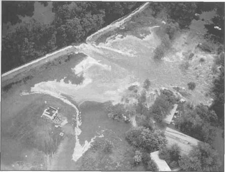
Quincy Herald- Whig photo by Joe Leisen Indian Graves Levee commissioners check damage from the floodwaters along the river near Quincy. as the "flood of the century," Sparks and Rhodes wonder whether that description makes it sound more rare than it may be. According to the National Weather Service, rainfall in the upper Midwest was 1 1/2 times normal this spring and early summer, Sparks said. "The big question is whether that amount of rain would have produced such a huge flood if we had not tiled, drained and paved over the uplands to speed water off the farms and urban areas as quickly as possible, or channelized streams to flush water quickly into the rivers, or constricted the main channel of the Mississippi with wing dams, or constricted the floodplains with huge levees." Even with that disturbing thought in mind, it obviously is too late to go back and re-do everything. So what do we do? Despite the huge devastation from the flood of 1993 (or perhaps because of it) some public officials are reluctant to discuss an important and obvious question: Where do we go from here? Under current federal policy, Anfinson said, the Army Corps only can build a levee if a cost-benefit analysis finds the levee would conceivably save more money in crops or property saved than it cost to build. He said it was too soon to tell whether that policy should change. A response that typifies the official attitude came from George Halford with the Army Corps' headquarters office in Washington, D.C. "It's too early to talk about any changes in policy, or whether it's right or wrong to build levees. Right now we're trying to hold damage to a minimum. Our whole focus is to bring people through this crisis now," said Halford, who was speaking from an office in Washington, D.C., hundreds of miles from flooded towns and cities. The irony apparently was lost on him. "We're not speculating on what's next." But the sheer magnitude of the flood's damage makes it seem obvious that something was not done properly. And others weren't so reluctant to offer ideas for future courses of action. Harry Hendrickson of the Illinois Department of Energy and Natural Resources' research and planning division pointed to federal and state home buyout programs, such as one begun in 1986 in Kampsville that he said "worked tremendously." Several people were relocated from the town, which lies on a peninsula between the Illinois and Mississippi rivers, to higher ground. Molly O'Toole, acting chief of flood mitigation programs for the Illinois Department of Transportation, said a similar program was completed in Phebes, Ill., along the Mississippi in 1991. Others suggested full-fledged moving of homes from flood-prone areas. In 1938, Anfinson said, homes were physically moved from flood-prone Prairie du Chien, Wis., to outside the floodplain. "That was the first nonstructural effort at flood control," he said. O'Toole said it is too soon to tell whether the 1993 flood will spur communities' interest in programs like these. "It's hard to gauge what towns think after a flood," she said. "We hope people don't think, 'Oh, this won't happen again.' We hope to help people see they don't want to be in a floodplain. The focus of programs like these is really damage reduction, but the results include restoration of open spaces in the floodplain." Gilbert White, professor emeritus at the University of Colorado at Boulder and acting director of the Natural Hazards Research Applications and Information Center (which he founded in 1976) is known widely as the "father of floodplain management." While a graduate student, he studied the Mississippi River Basin for the Franklin Roosevelt administration in the late 1930s, and wrote a landmark 1942 doctoral paper, "Human Adjustments to Floods," suggesting communities be planned away from floodplains. But now that they're there, he said, we must come up with other protective alternatives. "Cities like St. Louis are here to stay," he said. "They've got the huge, federal levees to keep them relatively dry. But
20/August & September 1993/Illinois Issues
Setting aside areas of the Mississippi's floodplain in which land would be taken out of production as current owners move or die, or buying owners out. "Instead of providing federal assistance to build levees, provide federal assistance to move and make sure owners are offered a fair dollar amount," he said. Sparks also offered some suggestions. "Government policy now seems inconsistent," he said. "For example, why do we pay some farmers not to grow crops at the same time we subsidize others to grow more in floodplains? We build and maintain levees in floodplains at federal expense while at the same time we pay farmers to set aside crop land in order to reduce surpluses and the need for price supports. If we need to reduce crop surpluses anyway, why not do it by buying out some of our agricultural levee districts that failed in the 1993 flood instead of rebuilding them?" He also said other levees should be modified with spillways or pipes so they can be used to reduce crests during major floods, letting water spread over farmland that would remain unflooded most years. As a society, Rhodes said, we're not at a stage where we want to see land taken out of production. "I don't see it as something happening real quick. But how much cost do we want to bear for flooded land? If we take land out of production and restore it to wetlands and they flood, it doesn't cost much." At the same time, taking land out of production means people may have to move when and where they might not want to a philosophy that "goes against the grain of what our country stands for," Rhoads said. "If this is a fluke, if the water truly is this high only once every 100 years, maybe we can absorb $10 billion or more in damage. But if it can get this high every 25 years ... is it worth it? "I don't want to say I'm glad this happened I'm not," he said. "It's a disaster. But this flood has shown the dramatic power of nature. If you try to rein it in, it will throw out something we can't handle. There has to be a willingness to compromise with it."
August & September 1993/Illinois Issues/21 |
|
|