|
Home | Search | Browse | About IPO | Staff | Links |
|
Home | Search | Browse | About IPO | Staff | Links |
Overview
Main Ideas
Connection with the Curriculum
Teaching Level
Materials for Each Student
A copy of the content portion of this article
Objectives for Each Student
Be familiar with the natural stream network of Illinois Suggestions for Teaching the Lesson
Opening the Lesson
Refer to the map in Figure 1 and a reference map (an Illinois road map for example) and label these rivers and streams on the blank map: Mississippi, Ohio, Wabash, Illinois, Chicago, Des Plaines, Fox, Kankakee, Vermilion, Spoon, Sangamon, La Moine, Rock, Green, Kaskaskia, Big Muddy, Embarras, Little Wabash, and Saline. Label the line that represents the Lake Michigan shoreline. Discuss the pattern of these streams. Notice that only one flows into Lake Michigan, all the rest are tributaries of the Mississippi. This is the natural stream network of Illinois, a product of physical forces.
Developing the Lesson
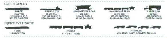
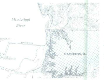
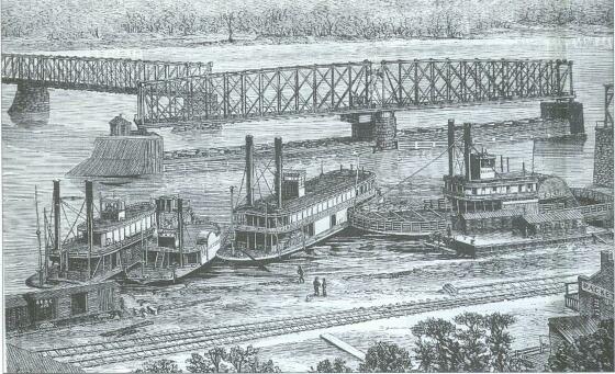
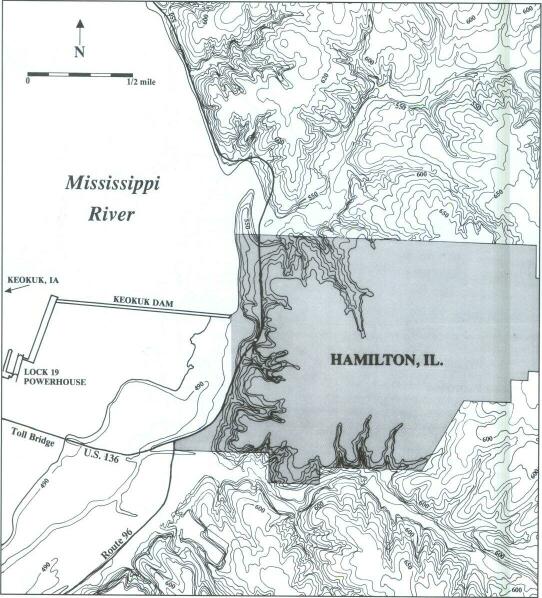
40 Now let us look at some other human interactions that are not so obvious locks and dams and levees discussed in this article. We can begin with the locks and dams. Refer to the road map and have your students locate and name the locks and dams on the Mississippi River and the Illinois River system. Have them develop a symbol to represent these features. On the Mississippi they are: Lock and Dam No. 27 at Granite City; No. 26R, Alton; No. 25, two miles downstream from Batchtown; No. 24, near Pleasant Hill; (there is no No. 23); No. 22, eight miles downstream from East Hannibal; No. 21, Quincy; No. 20, Meyer; No. 19, Hamilton; No. 18, five miles below Oquawka; No. 17, three miles above New Boston; No. 16, three miles below Illinois City; No. 15, Rock Island; No. 14, Hampton; No. 13, three miles above Fulton; and No. 12, Blanding. On the Illinois Waterway, there are locks and dams at LaGrange, Peoria, Starved Rock, Marseilles, Dresden Island, Brandon Road, and Lockport. There is also the O'Brien Lock and Dam on the Calumet Sag Canal, which is not shown on the map. Can your students locate any more locks and dams on other Illinois waterways? There is one near the mouth of the Kaskaskia River and six more on the Ohio along the southern border. Discuss the benefits derived from the above locks and dams. Dams can be constructed to serve different functions, but they are built primarily in conjunction with a lock to provide a safe and reliable deep-water channel for river transportation. The natural flow of the Mississippi varies considerably during the year and the stream also meanders, causing periods of low water and shifting sand bars that often resulted in boats running aground. Rapids must also be contended with. Dams alleviate problems caused by rapids by creating a series of deep, slow-water pools that stabilize the vagaries of depth and meandering, making it possible to transport barges that have 1,500 tons of cargo capacity. It is very common to see 15 barges in one unit being pushed by one diesel-powered boat. Have your students refer to the comparison diagram to solve problems similar to these. How many jumbo hopper railroad cars would it take to carry the equivalent of one river barge? Answer: 15. How many barges would be required to carry 315,000 bushels of corn? How many jumbo hopper cars would be needed to haul the same amount? How many large semi trucks would it take to handle this many bushels? Answers: six barges, 90 hoppers, 346 trucks. How many hopper cars and how many trucks would be required to carry the equivalent of one 15-barge tow unit? Answers: 225 hoppers and 765 trucks. The benefits derived from these structures in terms of transportation alone are tremendous. Both agriculture and industry depend on the relatively cheap and reliable transportation of bulk goods along the river. The dam at Hamilton generates electricity. Recreational boaters have come to depend on the safe navigational channel, and the deep pools that the dams impound offer a variety of leisure-time pursuits. These structures have a big impact on a stream's natural flow. Instead of a meandering, free-flowing river, the Mississippi upstream from St. Louis is now a series of deep, slack-water pools. In its free-flowing state, the river eroded, transported, and deposited sediments along its numerous shifting channels and its flood plain. Consider that these sediments, which are particles of sand, silt, clay and organic material, are very nutritious and are the basis of the rich bottomland soils along the river. Discuss how a series of dams would interrupt the transportation and deposition of these sediments. Because of the dams, the water is slower and the river is not as likely to change course. Under these conditions, the sediments will tend to settle on the river bottom rather than being distributed across the breadth of the flood plain. Also without the series of dams, the sediments would be free to gradually move down stream, where they would be deposited along the floodplain or ultimately to the river's delta where they would contribute to the soils and the base of the food chain. In a free-flowing channel,
41
COMPARE
the sediments would be flushed down stream especially during floods. With the dams, the sediments will slowly accumulate on the channel bottom. This subtle change in the stream will contribute to flooding because the base of the river channel is being elevated, and consequently there is less capacity in the channel to accommodate an increase in runoff, which could result in hazardous flood conditions. With this type of discussion your students should gain an appreciation for how a natural river system will likely respond in unforeseen and often disastrous fashion when humans alter the natural flow. The levee is another human creation that is designed to confine the river. It is usually in the form of an earthen embankment that parallels the stream and prevents flood water from encroaching on a variety of human endeavors ranging from cities to farmlands that are located on the flood-plain. Discuss the obvious benefits of these levees. It is likely that your students would consider the protection provided by these levees fully justified. It is understandable that people want and often demand protection from a river's floods. But like the dams, over the long term, levees tend to exacerbate the floods they were designed to confine, and they also prevent sediments from reaching the floodplain. Have your students consider that over the years a levee system may be successful at confining floods. How would this lack of flooding be detrimental to the floodplain? Remember that the sediments revitalize the soils along the river. Without this periodic nourishment the soils will wear out and will in turn require application of fertilizer. Some of this fertilizer will work its way back into the river and cause damage to the ecosystem. Now have your students think about where the sediments go that would normally have been deposited on the floodplain along an unconfined river. Like the dams, the levees tend to cause the sediments to accumulate on the river bottom. This will tend to elevate the river. The levees will in turn need to be built higher. Eventually the river will be elevated higher than the surrounding floodplain. Now, if a levee is breached during high water, a catastrophic flood is likely, with literally billions of gallons of water pouring into low-lying areas. The levees and the dams tend to delay floods, which have the appearance of benefiting humans along rivers. This in turn tends to lead to a sense of complacency and a belief that the river is truly confined by human technology, but over the long term the river will adjust to these structures and the costs will be tremendous. There is another aspect to consider with levees. The floodplain along an unconfined river is where flood water is temporarily stored. If people start building levees to deny water from the flood-plain in their vicinity, the water will be forced to rise in other places. Have your students evaluate the consequences of commencing levee construction. Once started, can any low-lying reach of the river be omitted? If a levee is constructed on one side of a river, what are the ramifications for a community on the opposite bank? If a levee is constructed upstream, what will happen to sites downstream? This process appears to be perpetual for all generations. Are there any cost-free solutions? Should levees have been constructed to begin with? Your students should conclude that there are no easy answers to these human-environmental interactions. We have discussed the benefits and costs of locks and dams and levees. We believe it would be helpful for students to visualize examples of these 42 features. Topographic map study should be a very rewarding activity for studying human-environment interaction. The U.S. Geologic Survey has large-scale 1:24,000 topographic map coverage for the entire state. On this scale, one inch represents 2,000 feet, and a considerable amount of detail is included. Contour lines on these maps represent lines of equal elevation and enable the map reader to visualize the landscape. Where contours are widely spaced, the land is relatively flat compared to an area where the contours are spaced closely together, and steeper slopes would prevail. A limited number of maps are listed here. Not all would need to be used for this activity. On the other hand, there are many more that could be added or substituted. The Hamilton, Illinois, map shows the dam, powerhouse, and lock. Analysis of the contours and the spot elevations should reveal that the pool elevation upstream from the dam is about 516 feet, while downstream it is about 480 feet. This is a difference of about 38 feet, and it is dams such as this one that create the deep, slack-water pools that permit the high-capacity barges to navigate on the river. Before 1913, there were rapids upstream from this dam; now they are flooded, and river traffic can pass over them relatively safely. The function of the lock would be to act as an elevator to raise or lower a barge through the dam depending on its direction of travel. Water is either added to the lock chamber or evacuated from it to raise or lower the barge. Downstream from the dam, the contours are widely spaced along the river, indicating the flatter land of the flood-plain. Maps that cover the river down stream include: Warsaw, Long Island, Quincy-West, Hannibal-East, and Ashburn. It is not necessary to be a proficient map reader to obtain an impression of the relationship between humans and their environment. For example, the word levee often accompanies the line symbols, and you should be able to begin to associate the various symbols with their real-world counterpart. You should be able to see that levees are numerous and nearly continuous along the river. Why were levees constructed? What are the benefits and what are the costs? Why are the lands along the river coveted as farm land? What are the disadvantages to farming on these lands? It is fairly obvious that levees can be a benefit to farmers on the floodplain, but considering that a stream carries nutrients that rejuvenate the soil, one should be able to comprehend that levees could block these nutrients from reaching the floodplain. There are also a large number of canals cut into the flood-plain. What is the purpose of these? Look for recreational facilities such as boatramps. Maps in the Chicago area include Sag Bridge, Berwyn, and Chicago Loop. These nicely illustrate the Des Plaines River, the Chicago Sanitary and Ship Canal, and the Chicago River. Maps along the Illinois River include Beardstown and Cooperstown. Notice that an extensive levee system has been constructed along the Illinois. On all the maps, look for signs of human modification of the environment, and try to determine the benefits as well as the costs of these changes. Dams and levees certainly have improved certain activities, but they have altered the natural river system and have caused problems as well.
43
Concluding the Lesson
Reinforce the importance of the natural stream network of Illinois and its attraction for human occupance and activity. Students should be able to understand that rivers provide tremendous opportunities and that people have modified rivers to increase those benefits. Most importantly your students should realize that a stream will adjust to those modifications with unforeseen and sometimes disastrous consequences. Your students should be able to study a river with the aid of maps and to identify the problems that humans may encounter.
Extending the Lesson
Assessing Student Learning
44
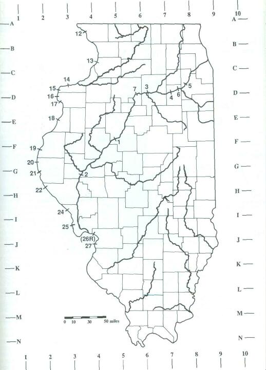
Fig. 1 MAJOR STREAMS OF ILLINOIS, INCLUDING LOCKS AND DAMS
45
Click Here to return to the Article 46 |
|
|