|
Home | Search | Browse | About IPO | Staff | Links |
|
Home | Search | Browse | About IPO | Staff | Links |
|

Robert Ashley and William D. Walters, Jr. In 1870 the initial settlement phase of Illinois' history was ending. Agricultural regions can be reconstructed from the federal census, and students can gain an idea of what the state was like in 1870. Equally important, students can gain some valuable experience in dealing with the concept that geographers call region.
How Geographers View Regions
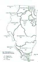
All regions are in some way distinct from the areas that surround them. Many single-topic regions are quite straightforward, and defining their limits presents few problems. Sangamon County is a region, and its limits are set by law. Likewise, the boundaries of a cornfield, while not legally established, are unlikely to generate much debate. But what about the concept of the Corn Belt? Its boundaries may vary widely depending on the criteria used for its definition. How much of the total land must be planted in corn before a particular county can be considered part of the Corn Belt? Must it be 70%, or is 50% or even 30% enough? How is the ratio calculated? By farms? By acres? By value of crops? By discussing those questions, the student can come to understand two important things-what the Corn Belt is, and the problems that confront geographers when they try to make sense out of the world. Establishing the limits of a region such as the Corn Belt only answers the first question of a geographer's investigation: "Where is it?" To understand other questions such as "Why is it located where it is?" or "How is it related to other phenomena?" the geographer must look closely at a host of related topics. The study of geologic history reveals the basis for the landforms of Illinois, and a study of the region's climate, including the four major glacial advances, helps us to understand the landform's subsequent modifications and the present-day drainage patterns. Soil types and natural plant and animal communities also provide insight into the physical environment. Superimposed upon the natural features of the region are human modifications. A particular way of farming developed at a given location because of combinations of natural and cultural conditions: important factors were fertile soil, proper drainage, adequate rainfall and favorable temperatures, proximity to markets, and access to transportation routes and terminals. But all of these were filtered through the settler's perceptions, which were influenced by cultural heritage and personal experience. Political decisions, market demands, and available technology also played a role. Availability of land was important. There are very good reasons why the Corn Belt is where it is, but an understanding of the reasons requires a close look at the very complex mosaic elements, some physical, some economic, and some cultural.
47
Students must be careful in dealing with cause-and-effect relationships; this is particularly true when dealing with natural environments as causes. Remember, corn is widely grown in environmental conditions very dissimilar from the Corn Belt. Moreover, conditions that are favorable for corn production may also be favorable for other activities, such as growing soybeans and wheat, fattening hogs, establishing sod farms, developing tree nurseries, or even raising produce for nearby cities. The Corn Belt is an example of what geographers call a uniform region. Its boundaries are set when a particular criteria such as acres of corn planted is established by a researcher. There are other kinds of regions. A city or town may provide a focus for the surrounding area for shopping, entertainment, or administration. Such a region is often called a nodal region. An example of such a region might be the circulation area of a newspaper that dominates the city in which it is published and gradually diminishes at the margins of the nodal region, where competition from another city's newspaper becomes stronger. A school district is a kind of nodal region with the school its node. While nodal regions are important for many studies, this exercise is concerned strictly with uniform regions. Teachers and students must realize that regions are not discovered, they are created. Like social class or historic period, region is an abstraction, a simplified mental construct that is useful only insofar as it aids our understanding of a much more complicated reality. It is also important to understand that one region often blends into another. Some areas clearly belong in one region, while others have all the characteristics of something that is quite different. But between those extremes there are likely to be transitional zones that share some characteristics of each. In east central Illinois there is a clear Grand Prairie agricultural region of which Ford County (the last county created in Illinois) is the most extreme example. There is little woodland, corn dominates, the population has been growing very rapidly (indicating late settlement, due probably to the lack of trees), and there is today still a great deal of unimproved land, which in 1870 was still unbroken prairie. All of the counties near Ford County share those characteristics in some measure, but as one examines counties farther away, they become less and less like Ford until eventually students will probably decide that those counties belong in another region. Click Here for Curriculum Materials 48 |
|
|