C U R R I C U L U M M A T E R I A L S
|
Robert Ashley
Overview
Main Ideas
Despite general statements that
describe large numbers of migrants from
Europe to Illinois in the middle of the nineteenth century, it is important to recognize
that each move was based on individual,
family, or group decisions. Such decisions
were not made lightly, for they meant an end
to the ways of life to which people were
accustomed in exchange for promises of
something better. For each person who
decided to venture into the new country,
there were many who chose not to leave.
One person's perception of extraordinary
opportunities was not perceived the same
way by another. Virgin farmland to one was
a wilderness to another; freedom to one
meant cutting ties to home and friends to
another. Little wonder "American letters" and
travelers' accounts of Illinois were so influential. Little wonder, too, that immigrants tended to move to those settlements that their
countrymen had already established.
Students of migration recognize two sets
of factors that influence decisions to move:
"push" factors are those undesirable features
that people want to escape; "pull" factors are
desirable features that draw people to particular places. Illinois in 1850 was a land of
great promise for many Europeans, as evidenced by the large proportion of immigrants
in its population. However, Figure 2 in the
narrative portion of this article shows that
immigrants tended to concentrate in some
areas and avoid others. Why? Furthermore,
some counties had distinctive national "flavors" while others either had few immigrants
or were mixed. Again, why?
Connection with the Curriculum
These materials could be used in
lessons in Illinois and U.S. history,
sociology, and geography.
Teaching Level
Grades 6-12
Materials for Each Student
A copy of this article's narrative
portion up to the section entitled
"Making Foreign-Born Migration
Field and Foreign Immigrant
Region Maps"
Copies of the reprinted written
accounts of Illinois travelers
Handout 2 - Base Map of
Illinois Counties
An Illinois highway map
Objectives for Each Student
Understand the importance
of "push" and "pull" factors in
decisions to migrate.
Recognize that perceptions about
places differ, depending on points
of view.
Understand the importance
of transportation to migration.
Recognize that the relative
locations of communities change
as transportation connect them.
SUGGESTIONS FOR
TEACHING THE LESSON
|
Opening the Lesson
Describe one or more scenarios of
undesirable social, economic, or
political conditions, such as those that
faced residents of mid-nineteenth-century Europe. Topics might include
political turbulence, religious persecution, landlessness of farmers, unemployment, poverty, and Ireland's potato
famine. Ask students to comment on
alternatives available to the affected
people. Explain that these and other
undesirable conditions may be "push"
factors that encourage people to move.
Show students a transparency of Table
1 (Birthplaces of Foreign Adult Males
in Illinois, 1850), and ask students to
comment on why Germany, Ireland,
and England were disproportionately
represented. Students will be predisposed to respond by citing those push
22
factors just mentioned. Be prepared to
describe briefly those conditions that
encouraged many to move. Explain
that push factors encourage potential
migrants to look for opportunities elsewhere. Illinois' cheap land and expanding economic opportunities were draws
during that period of time. Ask students
to predict those features that provided
a "pull" to immigrants. Define the term
"pull."
Show an overhead transparency of
Figure 1 (Foreign Migration Fields in
Illinois, 1850). Point out clusters of
national groups. Ask students to speculate why particular groups clustered.
Distribute the narrative portion of this
article up to the section entitled
"Making Foreign-Born Migration Field
and Foreign Immigrant Region Maps."
Assign the section as homework. Be
sure to discuss this section with the
students in class. Instruct students to
write in their notebooks examples of
pull factors that applied generally to
Illinois and specifically to particular
locations.
Developing the Lesson
Arrange students in small groups and
instruct them to compare their lists of
pull factors as described in the reading
assignment. Discuss as a class.
Emphasize that push and pull factors
go hand-in-hand; discontent may
encourage people to look for opportunities elsewhere.
Show an overhead transparency of
Figure 2 (Foreign Immigrant Regions
in Illinois, 1850). Distribute to each student or pair of students an Illinois highway map. Instruct them to compare the
two maps and select the city or cities
which are the foci of the core areas.
Plot and label responses on the transparency with a washable marker. Ask
students to describe the feature or features common to all. (All are on navigable waterways.)
The teacher should be prepared to
describe the importance of navigable
waterways to immigrants and to the
development of cities. Some important
considerations should include:
- The French established the earliest
European settlements in Illinois, with forts
and villages along the Mississippi, Illinois,
and Wabash riversoutposts of an
empire that stretched from Canada to
New Orleans.
- Early American settlers traveled down the
Ohio River and up the Mississippi on flat-boats and keelboats. Flatboats also plied
the waters of smaller streams, handling
cargo and passengers. Many new settlers
came overland from the Upland South
statesparticularly Kentucky and
Tennesseeand crossed the Ohio into
Illinois. By the time Illinois entered the
Union (1818), most of its population was
concentrated in southern Illinois.
- The first steamboat reached St. Louis in
1817, and by 1848 the Illinois-Michigan
Canal linked the Great Lakes with the
Illinois-Mississippi.
- The Erie Canal was completed in 1825.
Improvements in Chicago's port facilities
and a lighthouse in 1832 supported the
boom in Great Lakes schooner and steam
transportation. Chicago grew from 150
persons when it was incorporated in 1833
to nearly 30,000 by mid-century.
- River ports provide "breaks" in transportation, that is, points at which goods and
passengers must be shifted from one type
of carrier to another. Because of the need
for laborers, warehousing, and services at
such points, opportunities for employment
developed. The concept "hinterland" may
be introduced at this point and explored
later in relation to the following passages:
J. H. Buckingham's descriptions of Peoria,
in which he refers to Peoria's "large extent
of back country to supply;" and Chicago,
in which he refers to Boston as the
"Atlantic seaport of this great country." By
this time, New York had surpassed
Boston as the country's major seaport,
owing in large part to the expansion of its
hinterland by the construction of the Erie
Canal in 1825 and the beginnings of the
development of railroads. Indeed, Chicago
was connected to the East by rail in 1852.
The concept can be further explored as
part of the description of Chicago's growth
between 1830 and 1857. ("Hinterland"
refers to that area surrounding a seaport
city that is in that city's sphere of influence, dependent upon it for markets, jobs,
goods, and services. "Umland" is properly
used with inland cities. However, the term
hinterland is commonly used for both.)
- The relative location of a city changes
as transportation systems link it to other
places. As transportation time or cost is
23
reduced, a city may seem closer than it
previously did. Additionally, the improved
transportation of a city to its hinterland
solidifies the city's importance as the
region's center.
Refer students to the passage by
Morris Birkbeck (in narrative introduction) in which he promotes the colony
he founded in southern Illinois. Read
it aloud for emphasis. Note that while
Birkbeck did not tell any untruths, he
did not present a balanced picture.
Distribute Handout 1 (Impressions of
Illinois) written by European travelers
to Illinois. Each set describes the same
area, although not at the same time,
and certainly not from the same perspective. Assign students to read the
passages before the next class session. For each selection, students
should write in their notebooks one
statement to summarize the writer's
perception of the place.
Arrange students in groups of three
or four. Direct them to use Impressions
of Illinois and the review statement
they wrote as homework to address
the following questions:
- What factors may have contributed to the
different impressions the travelers had of
the places they visited?
- Which comments might serve as "pull"
factors, and which would discourage
immigration?
- Did the different times at which they
wrote influence their perceptions?
Why or why not?
- How did the writers who described
Chicago differ in their assignments of
the city's relative location? That is, how
did they see the city relating to its surrounding area and to distant places?
What were their reasons?
Each group should appoint a recorder
to take notes of the discussion and a
spokesperson to present the group's
ideas to the class. Provide time for
discussion, then conduct a whole
class discussion during which
spokespersons report. Ask them to
share their summary statements with
the class, and point out on a wall map
(or individual highway maps) the location of each as it is discussed.
Encourage students to imagine the
reactions these and other writings
might have caused in potential immigrants, if they had the opportunity to
read them.
It may be emphasized at this point that
the combination of the geographic perspectiveobserving the spatial characteristics of
a particular placewith the historicfocusing on a particular point in the pastcan be
mutually enhancing. The two studies are
complementary.
Concluding the Lesson
Ask students to recall why cities grew
in particular locations. Review topics
should include the following:
- Cities grew at breaks in transportation, especially at sites on waterways.
Land transportation facilities were
primitive.
- The population was largely agricultural, and people depended on local
markets.
- Most settlements were small service
centers, providing goods, services,
and markets for small hinterlands.
- The total population was small; it
was especially sparse on the prairies
of east-central Illinois.
24
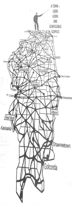
Display a transparency of Figure 4,
Urban-Road Networks in Illinois, 1844.
Point out Chicago and St. Louis as the
regional nodes, and ask students to
name the subregional nodes.
Distribute to each student Handout 2
(Illinois and Its Counties, Base Map)
and an Illinois highway map. Instruct
students to copy interstate highways
on the base map and plot the locations
of those cities of 75,000 or more population. Include St. Louis and the Rock
Island-Moline-Davenport-Bettendorf
conurbation; combine Champaign
and Urbana; combine Bloomington
and Normal. Alternatively, prepare a
transparency on which the interstate
highway system has been plotted.
Highlight the system with a colored
marker. Superimpose it on Figures
transparency.
Ask students to compare the two maps
and consider the following questions:
- What are the focal points of the interstate highway system? How does the
interstate system influence the relative
locations of cities?
- What changes have occurred in population distribution? Are the largest
cities of 1844 still the largest cities of
today? Why or why not?
- Which of the subregional and lower
level nodes were relatively more
important in 1844? How did their locational advantages diminish?
- Which cities are subregional nodes
today? What are the locational advantages that encouraged their growth?
Extending the Lesson
Distribute base maps of Illinois (with
counties drawn and labeled), an Illinois highway map, and the following list of
towns/cities. Instruct students to plot and
label Chicago, Cairo, and the other
towns/cities on the base map, then connect
all items with a single line. When they have
completed the task, tell them that all the
towns/cities were incorporated within the
same twenty-year period. Ask them to
describe what the communities have in common and to predict the twenty-year span. (All
are located on the Chicago to Cairo route of
the Illinois Central Railroad, completed in
1856. All were incorporated between 1855
and 1875.)
Plot and label: Chicago, Cairo, Anna,
Arcola, Bourbonnais, Buckley,
Carbondale, Central City, Centralia,
Champaign, Chebanse, Clifton,
Cobden, DuQuoin, Effingham,
Farina, Oilman, Kankakee,
Kinmundy, Loda, Mason,
Mattoon, Monee, Neoga,
Odin, Onarga, Paxton,
Peotone, Rantoul,
Richview, Sigel,
Tamaroa, Tolono,
and Tuscola.
Assessing the Lesson
Tell students that
one-fifth of the U.S. population moves each year,
making our people
among the world's
most mobile. Ask
them to consider the
following questions
about modern-day migrations within the nation,
state, and local
community.
Why do people
move? What push
and pull
factors are
involved? Did
you move to the
community where you
now live, or do you know
people who have? What
were your (their) reasons?
Did your (their) perception
of the community change
after the move? Direct
students to write a one-page description of their
community, explaining
push and pull features.
25
The following are excerpts from Paul M. Angle, ed. and comp., Prairie State: Impressions of
Illinois, 1673-1967, By Travelers and Other Observers (Chicago: The University of Chicago
Press, 1968).
Peoria. Peoria in 1833 was two years away from incorporation; it grew as a village near Fort
Clark and was platted in 1826. A ferry began operation and the first steamboat reached the
community in 1830. By 1847, steamboats arrived frequently (more than 1,200 in 1850), and
the city was connected to other cities by daily stagecoaches.
A. Patrick Shirreff, 1833
"The village exhibits marks of considerable age, but none of prosperity...
There being nothing to attract attention at Peoria, I recrossed the ferry..." (p. 129)
B. J. H. Buckingham, 1847
"Peoria is a beautifully situated town on the right bank of the river, and is already
the seat of a great business. It commands one of the most grand and interesting views
in the world, and is built or laid out something in the New England style. It has a large
extent of back country to supply, and has increased within a few years almost beyond
what it would be considered reasonable for me to state." (p. 246)
Prairies. Prairies were poorly drained, and marshy areas were experienced frequently.
Mosquitoes were plentiful; they carried malaria, known to the early settlers as "ague." Prairie
soils were very difficult to plow until the mass production of the John Deere steel moleboard
plow in 1847. Wood for building and fuel was scarce on the prairie. Most land travel was at
best a bone-jarring experience. Roads were not paved, and wheeled vehicles followed the
rutted wheel tracks of those left by earlier travelers. For these reasons, the prairies were
among the last areas settled in Illinois.
A. Chandler R. Oilman, 1835.
"We passed over a continued plain, intersected every now and then with a soft spot
of ground, where the wheels sank deeply into the soil. At the dawn of day we found
ourselves on a wide prairie, with scarce a tree in sight. The appearance of the prairies
disappointed me very much; the tall brown grass, coarse and scattered, gave to the
whole a ragged appearance; the ground was low and marshy, and at short intervals we
passed through what they here call slews. I thought, at first, that these slews were
rivulets, whose streams were dried up by the long drought; but I believe their true
character is long narrow ponds, or rather mud holes." (p. 155)
B. William Ferguson, 1855.
[We drove]"..out upon the great prairie. I do not fancy there exists in the old world
such a sight as we beheld. From an eminence, as far as the eye could comprehend
the scene, it traversed the richest undulating fields of grass, almost unbroken by fence,
plough, or house. We walked some distance up to the knees in the luxuriant
herbage ... The agricultural resources of this country are incredible." (p. 303)
26

Chicago. Chicago was little more than a trading post until the 1830s, when it enjoyed rapid
growth. Construction of the Erie Canal (1825) linked Chicago with east coast cities and
transatlantic trade. By 1857, the city was the focus of major transportation systems: the
Illinois and Michigan Canal linked the Great Lakes with the Illinois and Mississippi waterways, eleven rail lines converged there, and road systems continued to improve.
A. William H. Keating, 1823.
"The village presents no cheering prospect, as, notwithstanding its antiquity, it
consists of but few huts, inhabited by a miserable race of men, scarcely equal to the
Indians from whom they are descended. Their log or bark-houses are low, filthy and
disgusting, displaying not the least trace of comfort... As a place of business, it
offers no inducement to the settler..." (pp. 86-87)
B. J. H. Buckingham, 1847.
"The more I see of Chicago, the more I am impressed with the value of its increasing
trade with Boston, -for Boston is the Atlantic sea-port of this great country. Everywhere
one meets with something new to astonish and delight him ... I could write columns
about Chicago, and give statistics upon statistics, to show that it is the greatest place
of its age, and is destined to be still greater..." (p. 239)
C. Gustaf Unonius, 1857.
"Not only canals and numerous railroads have made Chicago one of the most
important business centers of the Union, without a doubt the most important in the
interior of the country. Its favorable location contributes fully as much if not more.
Located at the extreme south end of Lake Michigan, the point of departure for all of
the great watercourses, it is, one might say, the source of the extensive navigation
maintained on those immense lakes and through the great navigable rivers connected
with them. Thus it has direct communication by water with Canada and the Atlantic
and even with transatlantic ports. Chicago is connected by the canal with the almost
inexhaustible coalfields in southern Illinois and had easy access through the St. Mary's
Canal to the mining regions around Lake Superior. These conditions will be important
in promoting the future growth and prosperity of the city." (p. 293)

27

Click Here to return to the Article
28
|