 |
Home | Search | Browse | About IPO | Staff | Links |
|
Home | Search | Browse | About IPO | Staff | Links |
|
"May 13, 1804
...all in health and readiness to set out. Boats and everything Complete, with the necessary stores of provisions & such articles of merchandise as we thought ourselves authorised to procure " tho' not as much as I think nessy. for the multitude of Inds. thro which we must pass on our road across the Continent &c. &c"
By Nancy Nixon This unedited journal entry William Clark penned a day prior to the departure of the Lewis and Clark and the Corps of Discovery Expedition expresses his anticipation of the unknown adventure that lay ahead. The roots of the expedition
Imagine what it must have been like in the United States 200 years ago. Anything west of St. Louis was considered wild frontier, and Missouri and Illinois were still years from statehood. The Louisiana Purchase, known as the greatest real estate transaction ever struck, was signed in 1803, virtually doubling the size of our country. The Louisiana Territory, spanning 828,000 square miles, would be carved into all or part of 13 states in the following century. Thomas Jefferson, our country's newly elected president in 1803, had a vision of an expedition into this new and wild frontier that could blaze a trail to the Pacific coast. Fascinated by this land that he'd only heard about from trappers, traders and foreign explorers, he envisioned great trade opportunities and the possibility of new revenues for his rapidly changing country. He was also curious about the wildlife, plants, minerals and terrain in the newly acquired land, and how they differed from where he lived near the Atlantic coast. In early 1803, Jefferson requested $2,500 to fund the daring expedition, and in February, Congress approved it. Captain Meriwether Lewis, Jefferson's personal secretary, would serve as the expedition's naturalist, gathering
10 / Illinois Country Living / www.ipl.coop samples of plant matter, animals and minerals. Lewis asked William Clark, his friend and a career military man, to co-lead the expedition. Clark would take the lead in recruiting men for the Corps of Discovery military unit, establishing a training camp, and leading the men during the expedition. Training was a serious matter. The journey would span nearly two and a half years over 8,000 miles, and during that time the party would experience many obstacles, including rugged and unforgiving terrain, and many unfamiliar Indian tribes.
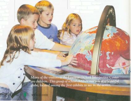
Although Lewis and Clark were trained cartographers (map makers), planning the expedition's route would prove difficult. The maps available at the time basically lacked information anywhere west of St. Louis. Fortunately, others had traveled west ahead of Lewis and Clark. Traders and trappers had been up the Missouri River. And, the explorers could gather information from the American Indians traveling down to trade in St. Louis or Cahokia. Once the plan was set, the explorers determined that the point of departure would be from the banks of the confluence (junction) of the Missouri and Mississippi rivers. Because the French still occupied the Missouri side of the Mississippi River, the camp was established on the Illinois banks. As its launching point, Illinois played a pivotal role in the Lewis and Clark expedition. On December 12, 1803, the first members of the expedition arrived to set up Camp River Dubois. During the next five months men were trained to become the Corps of Discovery military unit. All supplies and equipment that would accompany the men on this very long journey were also gathered, organized and packed. The time spent in Illinois prior to their departure has been the often-untold story. An interpretive center located near the camp's site offers the most comprehensive look at Illinois' contribution to the expedition. The Lewis and Clark Interpretive Center Until last year, only a monument on the banks of the confluence of the Missouri and Mississippi rivers marked the spot where the Lewis and Clark expedition originated. As a result of years of tireless planning and federal and state funds, the Interpretive Center at the Lewis and Clark State Historic Site was opened a year ago just west of the monument. The site is the first site listed on the National Lewis and Clark Heritage Trail. The site illustrates the preparation in both gathering supplies and recruiting and training men for the expedition. Interpretive Site Manager Brad Winn says, "The men were individuals who had varied military experience, or maybe none at all. When they came to Illinois, they were trained to act as a unit. The success of the expedition depended upon their ability to rely on one another." According to Winn, Camp River Dubois, a replica of which is located at the interpretive site, was the first of three longtime winter camps Lewis and Clark established during the expedition. He explains, "They built this camp for protection from the elements. It looks like a fort, but it just provided shelter for training the men and gathering supplies for the expedition."
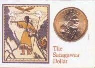
The Sacagawea gold dollar went into circulation in March 2000.
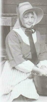
11 / Illinois Country Living / www.ipl.coop Interpretive staff and volunteers dressed in period clothing will work in the camp throughout the year once it's completed near year's end. Site interpreters have fully researched life at the camp in 1803 and will use that information to demonstrate the hardships the explorers endured preparing for the expedition without today's conveniences. Interpreter Pam Chait will rotate with two other women to act as the camp's only female. She says it will be even harder when winter comes because much of her work will be done outside in the cold. Chait adds, "Some of my purpose out there will be cooking, and hopefully I can cook enough to feed the site staff." She'll also demonstrate sewing and washing clothes. Not knowing how long the expedition would take made preparing supplies for the journey a formidable task. Winn says the supplies were an integral part of the story. He explains that while Lewis was out "spending on the government credit card" buying supplies for the expedition, it was Clark's responsibility to organize them and pack the keelboat and two smaller boats, known as pirogues. The 14,000-square foot brick-and-stone visitors center makes up the other half of the interpretive site. The visitors center boasts a state-of-the-art 100-plus seat theater and realistic exhibits that help visitors visualize life 200 years ago.
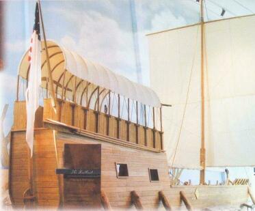
The highlight of the visitors center is a replica of the 55-foot long, 32 1/2-foot high keelboat (sailing boat) Lewis and Clark used for the expedition. The exhibit shows how efficiently space was used to house both people and supplies. The interpretive center was built to fit the specifications of the exhibits. The southwest corner of the structure was built with a high peaked roof, and walls that come to a long narrow point to accommodate the keelboat. Winn estimates that some 120,000 visitors have already visited the site since it opened. A staggering 31 million national and international visitors of all ages are expected to visit the Lewis and Clark Heritage Trail during the Bicentennial, between now and 2006. Many of them will visit the interpretive center. Winn says it's ironic that the first visitors at the center on opening day were from Oregon and Washington state, at the opposite end of the trail. Winn says another important aspect of the interpretive program at the site is comprehensive educational trunks, or travel kits, that he and his staff assemble for schools. The kits include everything a teacher would need to provide a Lewis and Clark lesson segment. He says, "We recognize there's not much information on Lewis and Clark being taught in the schools. That's why we're taking it to them. We want to make sure that people know about Illinois' role in the expedition." Federal and state monies funded the site — $4 million from the federal government through the National Parks Service, and just over $3 million in state funding. Those funds were spent on the center's physical structures. Private donations came from the general public and the Lewis and Clark Society of America, a strong advocate behind the Lewis and Clark mission, and a primary force behind building the interpretive center. According to Winn, private donations are used to develop special events and support interpretive programs.
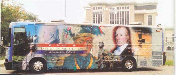
The mobile interpretive exhibit and a tribute to Sacagawea. While the interpretive center in Hartford is a place to visit and learn about life prior to the departure of the expedition, a mobile Lewis and Clark exhibit developed in Illinois will wind its way along the trail during the Lewis and Clark Bicentennial.
The 38-foot mobile unit, which was funded by a state tourism grant, was built to raise awareness across the Midwest for the Lewis and Clark Expedition. Jim Price, associate professor of art history and culture at Lewis and Clark Community College in Godfrey, developed the concept for the interior of the mobile museum. He says that maps are a primary focus of the exhibit. Like the interior of the exhibit, the title is a work in progress. Price says its current title is "Imagining the Nation: Seeing the Lewis and Clark Expedition Through Maps." He says, "We have maps from as far back as 1777, and up to 1901. We've used maps to show North America's perception of itself during 1770 and the Revolutionary War, and how it changed as a result of the Lewis and Clark Expedition." Price adds that historic foreign maps are also included in the exhibit. He says, "We have French and German maps, and a Japanese map that's just fascinating, because it turns North America upside down, which from their perspective was exactly right." There is even an 1892 circular map by American Indian Chief Otto on display. The mobile exhibit also includes maps that show the development of the state of Illinois. Price says there is a map of Illinois and Missouri that shows what they would've looked like around 18 years after the Lewis and Clark Expedition. From a physical standpoint, three categories of artifact reproductions are included in the exhibit: military instruments that would've been used during the expedition, Shawnee Indian artifacts, and scientific instruments used on the expedition for mapping. Many photos and copies of Lewis and Clark's journals are also included. The exhibit will travel to all the signature events for the Lewis and Clark Bicentennial Commemoration, following the trail from Camp River DuBois to the Pacific Ocean. It will be used to educate people of all ages. In addition to the traveling exhibit, a must-see landmark on the campus of Lewis and Clark Community College is a bronze statue of Sacagawea, the young Shoshone Indian woman who, as a guide and interpreter, was integral in the success of the Lewis and Clark Expedition. The statue was designed by artist Glenna Goodacre of New Mexico, who also designed the 1999 Sacagawea gold dollar. A smaller replica of the statue will travel with the exhibit. Price reflects on the importance of the exhibit, "I want people to understand how complex the expedition was and how it can be viewed from a variety of viewpoints, and how that reveals both who we are and what American dreams, illusions and understandings are, and how that impacts our present."
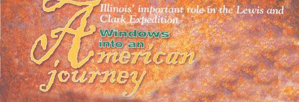
With anticipation stirring in all their hearts, Lewis and Clark and the Corps of Discovery embarked from Illinois on a journey that would impact history and open much of the western half of the United States. These Illinois-based historic sites and exhibits open windows into the origin of the expedition. This is Illinois' contribution to the great American journey.
(photo)Lewis and Clark Interpretive Center interpreter Pam Chait, who is dressed in period clothing, is one of three women who rotate to serve as the camp's only female. Here, she demonstrates washing clothes.
13 / December / www.aiec.coop
|
|
|
 The departure