|
Home | Search | Browse | About IPO | Staff | Links |
|
Home | Search | Browse | About IPO | Staff | Links |
|
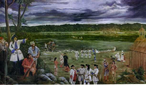
Recent research at the by Robert Mazrim The Peoria area is perhaps the least understood French locale in Illinois. Although it was the site of the first French military post in the Illinois County and occupied by French soldiers, traders, and families for over a century, few written records of life at Peoria during the eighteenth century are known. In contrast to the wealth of information provided by court, parish, and military records associated with the French communities in the American Bottom region, Peoria has been practically silent. The archaeological record of these occupations has been even more elusive, and prior to 2000, archaeological testing had failed to locate any traces of "French Peoria." In the fall of 2001, a proposed realignment of Adams Street in downtown Peoria presented an opportunity to archaeologically investigate an area believed to have been the location of an eighteenth century French village. The Illinois Transportation Archaeological Research Program (ITARP) conducted an investigation in the fall of 2001 under the direction of the author and David Nolan. These excavations encountered the first archaeological evidence of eighteenth century French activity in the region. The first domestic French settlement at Peoria, known as the "Old Village," is the focus of the research summarized here. The first French settlers In January of 1680, the noted French explorer Robert Cavelier Sieur de LaSalle constructed a small fort called Crevecoeur on the east bank of Peoria Lake. Later that winter, while LaSalle was away, the fort was looted by his men and abandoned. French activity was redirected to the Starved Rock area, but in 1691 the French returned to Peoria, where Henri Tonti and Pierre Deliette constructed a new fort called Fort St. Louis. At this post, and surrounded by as many as 300 Peoria Illini houses, a mission was soon established. The post and its mission were prosperous for a short time. Changes in colonial trade policy and the aggressions of Native Americans led to the abandonment of the fort complex shortly after the turn of the century, and the Peoria themselves left the area around 1722. The lake was reoccupied by the Peoria in the 1730s, although the French do not appear to have returned until the late 1740s, when an unlicensed trader constructed a small post. By the late 1760s, a cluster of French houses had been constructed in the vicinity of this post, and by the late 1770s several farms were located in the area. This locale ultimately became known as the "Old Village." In 1778 a second village, "La Ville de Maillet" (the "New Village"), was established, less than two miles downstream, and by the 1790s most of the residents of the Old Village had moved to this new location. Our excavations in the fall of 2001 were conducted at the locale thought to have been the site of the Old Village. Contemporary histories relate that a domestic French settlement began here as early as the 1730s. This date is based in part on assumptions that Tonti's Fort St. Louis had been located nearby, and that domestic trading activity followed the abandonment of the fort and the subsequent reoccupation of the Peoria area after the close of the Fox Wars. The origins of this village are poorly understood, however, and the assumptions of pre-1750 settlement there are substantiated by few primary sources. It is not until the 1760s that primary documents begin to suggest a domestic occupation of Peoria. Perhaps not coincidentally, these references follow the passing of control of the lands on the east bank of the Mississippi to the British in 1765. This resulted in an exodus of French families from the older villages in the American Bottom to villages on the west bank of the river. The true settlement of Peoria by French farm families may have been part of changes in the cultural landscape of Illinois in the 1760s. Residents of the French villages at Peoria first attempted to claim land grants from the United States Government under ancient claims acts that allowed for land grants to heads of families, militia men, and those who had improved land prior to 1783. The first Peoria claims were apparently made prior to 1806, but were not immediately granted, due to Peoria's location outside of Kaskaskia treaty boundaries and the vague descriptions of individual property boundaries... In an 1807 memorial to Congress, twenty-three inhabitants of "the Illinois and village of Pioria" asked Congress to reconsider the land claims made previously. The residents of Peoria apparently received no action on their claims until 1820, when Edward Coles, registrar at the Edwardsville Land Office, issued a report to Congress regarding the French claims at Peoria. In his report, he listed 70 claims related to both the old and new villages. Support for these claims was also included, and consisted of testimonies made by various residents and their descendants. It was not until 1837 that the land office made official reconstructed surveys of the old and new villages. That year, surveyors were sent to the sites, sometimes accompanied by the descendants of former residents. The result was a series of land office documents, including original and reworked survey logs, plats of individual 12 |ILLINOIS HERITAGE
lot claims, and reconstructed village plats anchored to section lines. The layout of the Old Village, as interpreted by the General Land Office in 1837, consisted of ten rectangular residential lots fronting a street that paralleled the river. Behind the western row of lots, lay three large "out lots" and two additional lots situated away from the main block of the village. The lots and streets that were resurveyed in 1837 were posthumous interpretations of what would originally have been a cluster of improvements and lot lines that had developed over decades, and which may have been altered and realigned during the life of the settlement. The plats of the Old and New Villages are unique to French villages in the Illinois Country, as they do not consist of what Ekberg has described the "tripartite" of French colonial village design. This traditionally consisted of residential lots, long lots, and commons. True long lots are lacking at the Old Village. Instead, residential lots are backed by three out lots, which differ from the traditional long lots used for cultivation. Out lots are thought to have been a late eighteenth century development, reflecting changes in the traditional agricultural and land ownership practices. In most cases, out lots were located away from the nucleated village itself, as are two such lots at the Old Village. At Peoria, however, even those lots connected directly to the residential lots are described by the land office as out lots, and claims testimonies suggest that they were used primarily for cultivation. Contemporary understanding of the location and limits of the Old Village of Peoria is based primarily on the work of Percival Rennick, who examined French land claims records associated with the Old Village in the 1930s. Rennick superimposed General Land Office survey data on then-modern maps, concluding that the limits of the Old Village as interpreted in the 1830s lay between modern city streets of Caroline, Hayward, and Jefferson, and the shore of the Illinois River. Based on an overlay of the 1837 land office claims surveys onto modern topographic maps, the 2001 project area was situated on a double wide residential lot fronting the main street running northeasterly through the village, and bounded on the north and south by two side streets. This was claimed both by Louis Chatellereau Jr. and the heirs of Gabriel Cerre. Testimonies stated that Louis Chatellereau Sr. built a house and cultivated the lot in 1778, and occupied it until his death in 1795. After Chatellereau's death, the lot was briefly occupied by Marie Josephe Tieriereau until the property was sold by the Chatellereau estate to Gabriel Cerre. Cerre was an influential merchant at St. Louis, and was originally from Montreal. Although few archival records pertaining to the residents of the Old Village are known, the estate of Louis Chatellereau is better documented (Continued on Page 15) ILLINOIS HERITAGE| 13 (Continued from Page 13)
due to the presence of a probate record and a mortgage agreement found at the Byron Lewis Historical Library in Vincennes, Indiana, and transcribed by Judith Franke and Richard Day. Chatellereau died in July of 1795. His estate included three horses, 25 head of cattle and oxen, and seven hogs. He also had 56 bushels of wheat and 500 pounds flour on hand, probably produced at his mill. His estate included "1 Negro fellow," who perhaps replaced the "red slave" he owned three years earlier. At his death he also owed wages to nine men for their work as engages, and one as a clerk. Two principal eighteenth century archaeological features were encountered during our excavations. Feature One was interpreted as a long wall trench, into which upright logs were once placed, and which was used to enclose an agricultural field or mark a lot boundary The feature was found to cross at least nine city lots, and measured over 270 feet long. Feature 2 consisted of the wall trench outline of a small rectangular porteaux en terre structure. The structure measured roughly 13 by 20 feet, and appears to have been divided into two nearly equal sized rooms. Evidence of a wall trench foundation for a gallery (open exterior porch) or narrow addition was found on the west wall of the building. This structure probably served as a dwelling, but it was small for houses in French colonial Illinois. Its location away from the main street and near a field fence (if they were contemporary) suggests that it might have functioned as a dwelling for a farm hand, laborer, or slave. With this in mind, it may have been occupied only seasonal. Feature 2 at the Old Village is only the fifth French wall trench domestic structure to be tested archaeologically in Illinois. Wall trench dwellings have been investigated at the towns of Cahokia, Prairie du Rocher, and Chartres. In present day Missouri, a wall trench dwelling was encountered at the Krelich Site, south of Ste. Genevieve. Very few eighteenth century artifacts were found in the block excavations around Features 1 and 2, or in the fill of the trenches themselves. Feature 2 produced a hand forged nail, four pieces of burnt limestone, and a single, larger slab of unburned limestone. The wall trenches of the structure also produced six pieces of dried mud chinking (or bousillage), and a small quantity of animal bone. The soils adjacent to Feature 2 produced a fragment of a wine bottle that appears to date between 1780 and 1820. The heel bone of a bison was also recovered from Feature 2. Having likely been deposited after 1780, the Old Village archaeological context for the bison specimen is one of the latest known in Illinois. If a French village in the Illinois Country is defined as a cluster of traditional houses and farms situated on lots with known or recorded boundaries, then the Old Village of Peoria was a small and short term example of such a community. However, if the definition of such a village is broadened to include less formal, hybridized, "Metis" type settlements reflecting a greater degree of aboriginal influence, then the settlements at Peoria can probably be regarded as much
As described since the early nineteenth century, Peoria served as the crossroads between the settlements and societies of Canada and those of Louisiana. The settlement on the west bank of the lake would have been familiar to many Canadian fur traders who made seasonal rounds through the lower Great Lakes, and was probably considered somewhat wild by the farm families living at Cahokia and Kaskaskia. Those villages, however, conducted fur trading business at Peoria on a regular basis. The potential for examining this hybridized and distinctive community will make further research at Peoria exciting and unique to the archaeological literature of the Illinois Country. Robert Mazrim is director of the Sangamo Archaelogical Center in Elkhart, Illinois, and a contributor to Le Journal, the publication of the Center for French Colonial Studies, where this article first appeared. For more information visit the Center's website at www.noctrl.edu/cfcs. ILLINOIS HERITAGE| 15 |Home|
|Search|
|Back to Periodicals Available|
|Table of Contents|
|Back to Illinois Heritage 2003|
|