|
Home | Search | Browse | About IPO | Staff | Links |
|
Home | Search | Browse | About IPO | Staff | Links |
|
The Geographic Setting
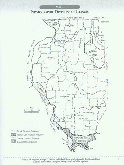
A person traveling across Illinois and observing the passing landscape is apt to comment on the flat, unvaried, even monotonous, nature of our prairie state. Even in its natural appearance, to really appreciate the native prairie, people had to see it up close, on foot, and sometimes even on bended knees. But when our travels take us to the boundaries of the state, a remarkable variety of landscapes come into view. This map, highlighting physiography—the lay of the land—shows us how Illinois touches four major provinces of North America, each with a distinctive geography. Reading the Map Start with the key in the lower left-hand corner. Note that the shading divides the state into four physiographic provinces, each with distinctive rock formations and landscape features. A flat to gently rolling topography in the Central Lowland Province characterizes almost all of Illinois. On the fringes, however, in the far southern and southwestern reaches of the state, three other provinces impinge on Illinois territory. The Ozark uplands, which reach mountainous proportions in Arkansas, extend across the Mississippi River in the Lincoln Hills and Salem Plateau sections. The Shawnee Hills have a similar surface appearance, but the rock structure is an extension of the Interior Lowland Plateau that extends into Illinois from Kentucky. Finally, a sliver of the Gulf Coastal Plain marches way up from the Gulf of Mexico to cross the Ohio River into the southern tip of Illinois. The Central Lowland Province, left unshaded on the map, covers most of the state. However, it can be subdivided into several sections listed at the edges of the map. The Great Lakes Section in the northeastern corner of the state comprises the Chicago area where most Illinoisans live. It contains both the old lakebed on which the city is built, and the gently rolling suburban areas of the Wheaton Morainal Country. A moraine is a deposit of miscellaneous rocks, gravel, sand, and soil left behind by the great ice sheets that covered almost the entire state during the Glacial Epoch. Till refers to similar glacial left-behinds and associated soils blown into the state as the glaciers retreated. Spread out as plains or arranged in gently rolling country at different times and in different ways, till areas receive different names in each section of the state, always referring to a major city, town, or river in the area. One section—the Wisconsin Driftless Area in the northwestern corner of Illinois—was missed by all the ice sheets. As a result, it retains the hilly, pre-glacial topography of the former geological period. Working with the Map Students should color the map, starting with the key and selecting their own three colors for the Ozark, Interior Low Plateau, and Coastal Plain provinces. Ask them to reserve green for the Central Lowlands, where they can outline the various subdivisions with their colored pencils. Warn them in advance to take care on the Galesburg Plain because the map extends these plain boundaries west of the Mississippi River. The lands in Iowa should not be colored, so that the shape of Illinois can be emphasized. Teaching with the Map First, have students view a map of the United States and note how Illinois is situated in the nation's heartland. Then note how it touches the Great Lakes and fronts the Mississippi River. Be sure to locate the Ozark Mountains, the Gulf Coastal Plain, and the Kentucky Uplands on the national map and then note how these physiographic provinces reach into the southern parts of the state. 2
3
The Geographic Setting
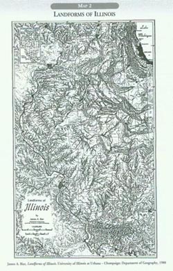
LANDFORMS
OF ILLINOIS It is always a great challenge to depict the three-dimensional surface of the earth on a two-dimensional sheet of paper. This is especially true of landform maps where lines and shading try to fool the reader's eyes to see hills and valleys. James A. Bier, a master cartographer from the University of Illinois at Champaign-Urbana, created this dramatic presentation of the state's topography in 1980 for the Illinois State Geological Survey. The map may appear crowded, confusing, even daunting at first glance, but careful study will yield rich rewards. With this map in your hand a drive across Illinois will never be the same again. In place of "flat, unvaried, even monotonous" views, landscapes will spring to life, acquiring a dynamic quality as they reveal the titanic forces that have shaped the landscape and shaded Bier's map. Reading the Map Before scrutinizing the details of Bier's map, note that it presents five major categories of information.
1. Hydrographic features like Lake Michigan and the Mississippi River
Since the boundaries of the state may not be clear, observe how the map emphasizes a landscape naturally flowing across the continent, paying little attention to political lines. Therefore it would be a good idea to first trace the perimeter of the state starting with the Mississippi River in the upper left-hand corner—the tri-state area where Illinois, Wisconsin, and Iowa meet near Dubuque. Then trace the river boundaries of the state south to the Ohio River, continuing up its course to its tributary, the Wabash, and then northward again to the Indiana state line. Conclude by following the shore of Lake Michigan and the Wisconsin state line to return to the Great River. 4 Now it is time to explore the entire state, noting three types of relief. First, observe the valleys cut out of the level plains by rivers as they eroded their banks and sent the soil downstream, where it was eventually deposited in the delta of the Mississippi River. Next note the extensive glacial moraines laid down by the last advance of the great ice sheet, called the Wisconsin phase of geological time by earth scientists. The third type of topography—the older dissected plateau of pre-glacial times— is clearly distinguished in the northwest corner of the state and in the southern portion. Working with the Map The moraines form rough concentric circles around the contour of Lake Michigan, indicating that the present shape of both the lake and the surrounding country resulted from the last glacial advance. The southernmost morainal ridge marks the furthest extent of the Wisconsin glacier. This landform—the Shelbyville Terminal Moraine—divides the state into two parts. The older topography, to the south and west, marks the parts of Illinois to be settled first by Europeans. The newer landscapes of the Wisconsin glaciation were settled last. After marking the boundaries of the state in blue, students should color the Wisconsin stage moraines in green. If the Shellyville Moraine seems to divide the state into two major sections, the Illinois River unites it. Note how the state's river reaches up across Illinois from its mouth, just above St. Louis, then snakes its way up to its two major sources: the Kankakee River which skirts the Valparaiso Morainal System south of Lake Michigan, and the Des Plaines River, which flows through these hills to drain part of the Chicago Lake Plain. The Illinois River system extends to within a few miles of Lake Michigan near the Wisconsin border (see Map 5) providing a water route across the state to connect the Great Lakes region with the Mississippi River. This is one of the great facts of the state's history and geography, a point of continental significance and one noted by the first Europeans to cross the state via the Illinois River system: Jolliet and Marquette in 1673. (See Maps 8 and 9) Ask students to use their blue marker to trace the course of the Illinois, Kankakee, and Des Plaines rivers. Before leaving Map 2, students should locate their home county and shade it in an appropriate color. Then they should use a bold dot to locate their home or school. After selecting another place across the state, they might use the map to write an account of a journey from one place to another, either today or in 1673. Students should note the landforms and rivers that the party would cross on this trip. Teaching with the Map Teachers will want to make overhead transparencies of Maps 1 and 2 and place one on top of the other to show students how the physiographic divisions work out on Bier's portrait of the state. The original printing of this map came in a much larger format so that individual features and place names were much easier to read. Teachers should enlarge this map on a photo copy machine or, better yet, order a classroom set of original maps from the Illinois State Geological Survey, 615 E. Peabody Drive, Champaign, IL 61820-6964 (217) 333-4747. Any class discussion of the rivers of Illinois will require a map of the United States or of North America so that students can explore the full extent of the Mississippi River system. Even a world map will show the Mississippi Delta in the Gulf of Mexico, the next resting place of the soils which the glaciers and the postglacial winds brought to Illinois from places to the north and west. Student interest built up by composing a journal of exploration can lead naturally to the activity sheets for Maps 4 and especially 5.
5
6
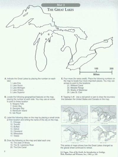
The Geographic Setting The Mississippi River and some of its major tributaries define the general shape of the state of Illinois, but the great majority of its people today are clustered around the southwestern tip of Lake Michigan. With only 60 miles of lakefront, Illinois is the least of the Great Lakes states in terms of shoreline. But over the last two centuries, people have turned this beachhead where the prairies meet the Great Lakes into the city called Chicago. To get a balanced perspective on the state's geography, we must consider Illinois as a Great Lakes state before turning to the great river system of the mid-continent. Reading the Map This outline map comes equipped with an activity to help students check their knowledge of the place names of the largest containment of fresh water in the world. The size of the Great Lakes becomes apparent when a scale of miles is added to the outline map. From the western point of Lake Superior to the eastern extremity of Lake Ontario is a distance of over 800 miles, about the distance between Chicago and New Orleans. As great holes in the earth's surface scraped by continued glacial advances, the three upper lakes point in the directions taken by different lobes of the ice sheets. Observe the course of these ice flows on the map. Then note how the glaciers seem to have sputtered over the lower two lakes, scooping out two broad troughs instead of making great ruts. As the ice sheets advanced, piling a mile or two of ice and debris on top of the land, the surface of the continent was compressed. Then as the glaciers retreated, removing the burden, the land slowly rose again, seeking its former elevation. This process of adjustment continues to this day in the upper Great Lakes region. This "surface rebound," combined with huge seas of melt water, kept the great lakes constantly changing in size and shape. Our outline map thus presents only the latest phase of an emerging geography, but one that is accurate for the last few thousand years. The essence of reading this map is to sense the dynamic changes caused by the glacial advances and retreats. The static lines should be viewed as the last stage of shifting shorelines with a variety of outlets to the sea. Today the flow of the lakes is generally eastward, with Lakes Superior and Michigan sending their waters into Lake Huron. After squeezing through a set of constricted channels, the waters flow eastward in Lake Erie, then tumble over Niagara Falls into Lake Ontario. At the end, they use the St. Lawrence River to reach the sea.
This was not always the case. In the midst of the ice sheet's retreat the glacial lakes, overflowing with melt waters, found outlets down the Mississippi, Ohio, Hudson, and other rivers. The old depressions, which carried the waters southward, are called spillways. They no longer drain the lakes because water levels have dropped and the floors of the spillways have risen as the land slowly regained its former elevation. People used these spillways in Wisconsin, Illinois, Indiana, Ohio, and New York as routes for travel. Indian trails, modern highways, railroad tracks, and especially nineteenth-century canals, followed these spillway depressions. Working with the Map Students should start working with the map by following the directions on the activity sheet. Advanced students might want to create a series of maps to show the changing geography of the lakes in the last stages of the Ice Age, following the sequence on page 157 of a View of the Past: An Introduction to Illinois Geology by Christopher J. Schuberth, first published by the Illinois State Museum in 1986. At the very least, mastery of the outline map demands that students come to know the Great Lakes as major geographical landmarks in North America that point to dynamic changes in the past. Adding arrows of different colors to the map to mark the directions for glacial flow, the locations of major southern outlets, and the course taken by today's waters will help add this sense of dynamism to the static map. Teaching the Map Enlarging the outline map several times on a photocopy machine to create an 111/2-by-17-inch image will provide a good start for a bulletin board display. A committee of students could use it to create a thematic presentation with pictures and information panels on such subjects as "Cities of the Great Lakes," "The Great Lakes: Past and Present," or "Natural Landmarks around the Great Lakes." Lorado Taft's neo-classical sculpture Fountain of the Great Lakes pictures the lakes as Greek maidens pouring water to trace today's flowage from the middle of the continent to the Atlantic Ocean. The pool at the base of the figure represents the Gulf of St. Lawrence and the Atlantic Ocean. The masterpiece is set in the splendid South Garden of the Art Institute of Chicago, facing Michigan Avenue. This "geography lesson" in the form of high public art is worth a special report when a class is studying the Great Lakes. 7
7
The Geographic Setting
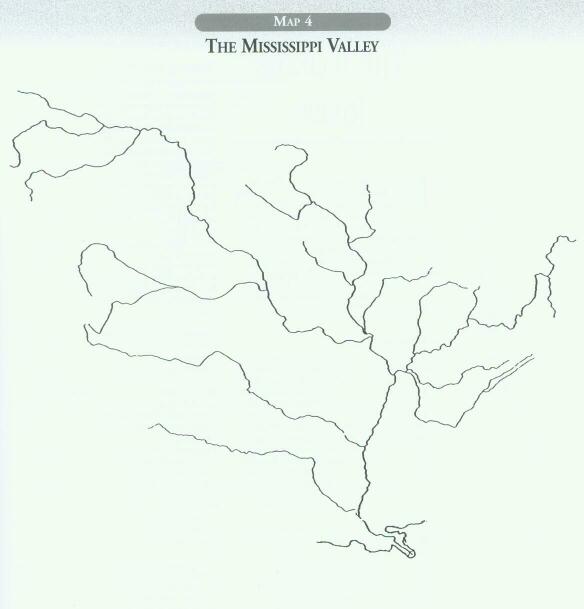
Like the Great Lakes, the story of the Mississippi River and its great valley is marked by change. Advances and retreats of the ice sheets constantly shifted the main channel as the Mississippi and its branches served as the major outlet for melt waters. The changes in the river continue today on a much more restricted scale, as it shifts course, slowly moving its islands downstream, and rising and falling with the seasons. Human effort, through dams, levees, and channels have helped stabilize the great river. But in the scale of geological time, these are only short-term solutions. Once again, students should be encouraged to view this outline map of the Mississippi Valley as a dynamic system with a history of change. Reading the Map The primary message of any map of a river system is to illustrate natural drainage, that is, how water collects throughout the area from rain and melting snow, is channeled into major branches, and then travels to the sea by way of a main stem. To fully grasp the message, the reader must mentally sketch in the surrounding elevations of land, which create a basin for the river and separates one river system from its neighbors. On this particular example, the map-reader mentally will fill in the Rocky Mountains in the west, the Appalachian Mountains in the east, and glacial moraines and uplands that define the Mississippi Valley to the north. Focusing on the water course itself, students should be encouraged to see it as a drainage facility first, but then to envision it in other ways, as a transportation system, as an obstacle, as a convenient source for political boundaries, as a natural resource, and as a unique ecosystem. The Mississippi Valley is the heartland of the North American continent, often called the central lowlands because only a few isolated places reach higher than 5,000 feet above sea level. The vegetation, however, varies widely as the climate changes from sub-tropical warmth at the mouth of the river, to the bitter cold of the continental harsh winters in the northern portions. Proceeding east to west, the climate also changes dramatically as the annual precipitation diminishes. One key to the geography behind the map is to note the one-hundredth west meridian, which is often used as a rough boundary between wet and dry America. Working with the Map After completing the worksheet assignments students can label the landscape features that define or give variety to the Mississippi Valley: the Rocky Mountains, the Appalachian Mountains, the Ozark Uplands, and the Black Hills. Several helpful lines from the geographical grid also could be lightly sketched in: the ninetieth west meridian crosses the Mississippi Delta and the cities of New Orleans (Louisiana), Memphis (Tennessee), and Belleville (Illinois) in the St. Louis metropolitan area. The forty-fifth north parallel marks the line midway between the Equator and the North Pole. It forms the boundary between Wyoming and Montana and passes through the twin cities in Minnesota. The one-hundredth west meridian, as mentioned above, is a rough division between wet and dry America. Teaching with the Map This map is a companion to the outline map of the Great Lakes (Map 3), and there will be a natural tendency to combine them. Make sure that both maps are reproduced at the same scale. Then help students to understand the importance of Chicago's location as a connecting point between these two great drainage basins. A map of North America will enable students to properly align their two maps. A world map will help them compare the Mississippi Valley with some other drainage systems of continental scope: the Amazon, the Congo, the Hwang He, the Volga, the Danube, and so on. There are many opportunities for bulletin-board displays and special reports when studying rivers. The general entry "Rivers" in an encyclopedia will help generate ideas and topics for reports. 9 THE MISSISSIPPI VALLEY: AN OUTLINE MAP A. Label the most prominent geographical features (use "R" as an abbreviation for "River"):
B. Label the other major tributaries of the Mississippi named after states: 6. Illinois River C. Label the major tributaries of the Ohio River: 11. Wabash River D. Number some key geographical features of the Mississippi River system: 16. Lake Itasca, source of the Mississippi River E. Place a small circle at the location of the following cities, and place the correct number next to it: 21. St. Louis F. For extra credit, mark the head of navigation on these rivers with a red line across the channel: 31. Mississippi: at the Falls of St. Anthony G. Special regions can also be highlighted on this map. Draw the boundaries and use color shading for the following, providing a key at the bottom of the map: 31. Yellowstone National Park 10
11
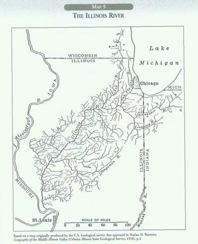
The Geographic Setting
The importance of the Illinois River to our state is strikingly evident in this map of its entire system. Each state that borders the Mississippi River, except Louisiana, has a major river named after it whose waters flow into the great river. The Missouri is the longest of these major tributaries, but the Minnesota, Wisconsin, Iowa, Arkansas, and Illinois are all key features in the geography of their states. The Kentucky and Tennessee rivers, strictly speaking, are tributaries of the Ohio, the main eastern branch of the Mississippi. Reading the Map Before focusing on the Illinois River, note that two major cities are situated near each end of the stream: Chicago at its source and St. Louis near its mouth. The map also reveals that several branches of the Illinois reach into neighboring states of Wisconsin and Indiana. A drainage pattern like this is often called the dendritic (tree-like) type. The system is composed of a major stem, important tributaries, and many creeks that drain the basin to supply the larger rivers. Only a few small lakes are part of the Illinois drainage system. Wetlands and the soil itself act as reservoirs to keep a supply of water constantly on hand to send downstream. The headwaters of the Illinois reach to within a few miles of Lake Michigan, but they never tap the waters of the Great Lakes, which are, in fact, several feet higher than the river's sources. In 1900 Chicago's Sanitary and Ship Canal was cut deep enough into the divide between Lake Michigan and the Des Plaines River to start draining the lake water into the Illinois system. This feat reversed the flow of the Chicago River. It drained naturally into Lake Michigan, but after the canal cut into the source of its South Branch, the waters turned around and headed toward the Mississippi. Other Great Lakes states and Canada soon objected, fearing that this diversion of water, following an old glacial spillway, would lower the level of the Great Lakes, threatening their harbors and water supply. A compromise was made, and locks were constructed at the mouth of the Chicago River to regulate the flow of lake water into the river system. Working with the Map
A map of the river system provides an opportunity for beginning students to review the basic terms describing a river: its source, mouth, course, basin, tributaries, bed, current, seasonal flow, and floodplain. Note that the Illinois River proper begins where the Des Plaines and Kankakee rivers meet, but its most distant sources extend into Wisconsin and Indiana. Governments often improve rivers to promote economic development. The state extended the Illinois River system by connecting it to the Great Lakes with the Illinois and Michigan Canal in 1848. Later, a second canal, the Illinois and Mississippi, opened in 1907. This waterway is often called the Hennepin Canal after the town on the Illinois River where it begins. It reached the Father of Waters by way of the Rock River, joining that stream just east of Moline. Students should draw these two canals on the map and label them. As rivers and canals encouraged economic development, cities and towns sprang up along their banks. Students can locate the following key places by referring to a state highway map and then place the names on the outline map.
• Peoria. The largest city on the Illinois River, it dates from a French fort erected in 1691.
A historic highway developed in the 1920s carried motor vehicles between Chicago and St. Louis and then westward all the way to Los Angeles on the Pacific Ocean. Route 66 in Illinois roughly paralleled the Illinois Waterway, as does Interstate Highway 55 today. Students could draw these routes on this map and then discuss the meaning of a transportation corridor in broad terms, using a map of the United States for purposes of illustration. The route from Chicago to St. Louis has always been a major artery in the continent's transportation system. 12
13
Teaching the Map Each of the major tributaries named on the map is important in its own way. Students might reflect on the various ways rivers provide meaning for our lives by matching the following descriptions with the appropriate stream:
14
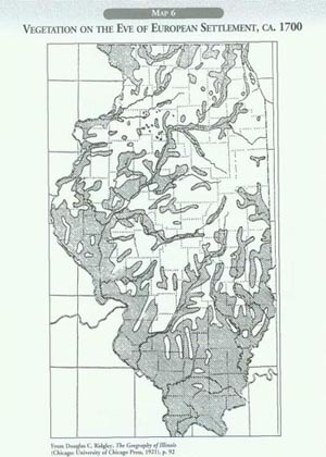
The Geographic Setting
Every map needs a title and a date. We took some care in selecting these items for this map. In former times, such maps were labeled "native vegetation," but now we realize that vegetation constantly changes, even in the "native" period before intensive human settlement occurred. In the case of Illinois, the term "natural vegetation" is also misleading in another way. By nature, given the soils and climate, the state should have been covered with forests in 1700. But most of the state remained grassland, as it had been for at least several thousand years between the retreat of the ice sheets and the arrival of Europeans. No one is sure exactly why this was true, but Illinois remained the prairie state when one would expect it to be part of the great forest that covered eastern North America. Reading the Map In reading this map, prairie fires come into mind. Fire is the best explanation of how the grasslands held off the woodlands, restricting them to the hilly areas at the margins of the state, to wetlands along riverbeds, and to groves of fire-resistant oaks scattered across the prairies. Did these prairie fires that kept out the trees occur naturally as a result of lightning strikes, or were they purposely set by the native peoples to aid a hunting economy? Perhaps the correct answer is to include both factors. At any rate, frequent fires explain why the natural forces encouraging the advance of the forests were held at bay for many centuries.
The modern climate of Illinois rules out rainforest, desert, and tundra types of vegetation, leaving only grasslands and forests to fight it out for supremacy. Thus a great struggle had been going on century after century in the post-glacial epoch up until the very time that white settlers arrived. The pioneers settled the matter by turning most of the grasslands as well as the tree cover into fields, pastures, cities, and towns. Working with the Map As students work with this map they should have a big question in mind: "What is so special about the Prairie State?" Show them Map 7, which presents the question in graphic terms. It shows how the grasslands characteristic of the Trans-Mississippi West reached eastward across the Great River and created a peninsula of unexpected vegetation. The intrusion reached across the entire state, touching the Great Lakes at Chicago. If human beings had not interfered, both before and after the contact between Indians and Europeans, would the trees have gradually overcome the grasses? 15 As students color the forested areas dark green they might use some of the previous maps in this section to explain the presence of trees in these particular locations. Was it due to the hilly topography, to protections from fire offered by rivers and wetlands, or is it an instance of an island-like grove composed of fire-resistant oaks and hickories? Although geographers have called the Illinois landscape a prairie peninsula, most early European observers reversed the metaphor and called it a sea of grass and flowers. In the course of the nineteenth century, only a few fragments of the former prairie ecosystems escaped the plows of the farmers. Some small areas are being restored with plants, but the great vistas that created the image of a prairie sea are gone, except in the imagination, in paintings, and on maps such as this. To see the Prairie State, one needs imagination. Teaching the Map Almost every place in Illinois has a fragment of forest, grove, or prairie nearby, inviting teachers and students to visit these nature preserves with maps in hand. Mark these locations on the map using dots, arrows, or an appropriate symbol. For some counties, the large-scale maps of the vegetation pattern as it was at the beginning of the pioneer period have been prepared. These are always based on the records provided by the original surveys of the General Land Office early in the nineteenth century. Ask local natural history experts if a map like this is available for the area about your school. One such map for the Chicago area was published by the Field Museum of Natural History. Another study is currently being conducted at the Morton Arboretum. A good, brief explanation of the prairie and grove landscape by Arlin D. Fentem is found in Illinois: Land and Life in the Prairie State, a publication of the Illinois Geographical Society edited by Ronald E. Nelson, first issued in 1978 and updated in 1996. 16
17
18 |
|
|