|
Home | Search | Browse | About IPO | Staff | Links |
|
Home | Search | Browse | About IPO | Staff | Links |
|
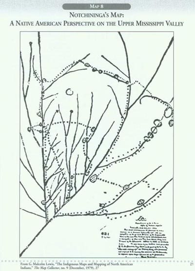
The story of people in Illinois—their knowledge about its landscapes that we call geography, and the account of how they utilized and shared its resources that we call history—all of these begin with the Native Americans. Indians lived here from the time the ice sheets retreated up to the present day, compiling an unrecorded history that reaches back thousands of years before written records to embrace different cultural traditions, a variety of ways to make a living, and a multitude of languages. Much of the story is unknown, but some parts are richly documented by the archaeological record. We assume that each new group learned something about the land from those who came before. This was certainly true of the European peoples who arrived on the scene in the late seventeenth century. Their first maps were based on their own observations plus the knowledge they gained from the Native Americans. Thus it is appropriate that we begin our historical narrative with an Indian map, even though it was made in 1837 for a different purpose. Similar maps could have been drawn earlier. We know from the accounts of the French explorers that they were guided into Illinois by such drawings and the geographical knowledge on which they were based. Reading the Map Notchininga, a chief of the Iowa people, drew this map to illustrate his presentation at a great peace council held in Washington, D.C., in 1837. He translated his knowledge of American geography into something like the European maps to tell the story of his people. He used the map to make a case for the Iowa's claims to lands that had been ceded to the federal government in treaties made by other tribes. The map is thus a historical map, showing the migrations of the Iowa people over the course of several centuries, represented by the dotted lines. The straight, solid lines on the map represent the upper portion of the Mississippi River system. This is probably a secretary's record of the actual map used by Notchininga in his speech, so it may not be an exact copy. Nevertheless it is a remarkable document in the expanse of the geographical and historical knowledge that it records. The major stem of the design is the Mississippi River, flowing from the upper right to the lower left. The main branch, a long vertical line, is the Missouri River. The branch at the lower right is the Illinois River, with the Wisconsin River just above it. The story of the Iowa people starts in the circle at the upper right, on Green Bay, where the new tribe split off from a Sioux-speaking people that lived by fishing on Lake Michigan. The Iowa then followed a way of life based on rivers, migrating back and forth across the Mississippi Valley. Thus, to fully understand the map, the reader must not only relate the sketch to the geography of the region, but also to the history of the Iowa people. 19 Working with the Map Using today's terminology, Notehininga's sketch presents a mental map of the upper Mississippi Valley. Students could use the outline map of the Mississippi Valley (Map 4) to bring the map into geographical focus. They might label the major features on the 1837 map, providing a title and a caption to explain its purpose. Then they could use family resources to develop a similar sketch map to record their own personal history, going back one, two, or three generations. In some cases, these family mental maps would focus on one community. In other cases, the geographical coverage might extend to the entire nation or even to the whole world. Notchininga explained the time dimension on his map by the historical account related in his speech. Ask students to develop a way to indicate the passage of time and to indicate dates on their own sketch maps. Teaching the Map Teachers will want to capitalize on a variety of opportunities opened up by this fascinating document, but for our purposes they should use a current map of Illinois to relate the migrations of the Iowa people to the state. It appears that Notehininga's ancestors had important Illinois settlements (see the circles on the map) near Galena, Rockford, Peoria, and Prophetstown. These places were also important to other Indian groups, which is the very point that led to the drawing of the map. Even very young students can make a connection between the Indian presence in Illinois and the Midwest by noting that we still use their names for our places: Illinois, Mississippi, Chicago, Iowa, Minnesota, and so on. The original copy of Notehininga's map measures 41-by-27 inches and is kept in the National Archives in Washington, D.C. (Records Group 75, Map 821, Tube 520). It is conveniently reproduced in the splendid account of Another America: Native American Maps and the History of Our Land by Mark Warhus (New York: St. Martin's Press, 1997). See especially pages 37-43. 20
21
The Illinois Country 1673-1787
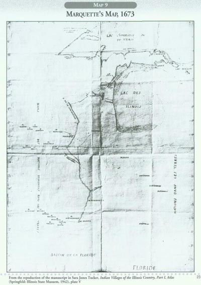
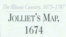
The documentary history of the Illinois Country starts in 1673 with this map by Father Jacques Marquette. He drew it during the winter of 1673-1674 after returning to Green Bay, completing a journey of discovery down the Mississippi River with Louis Jolliet. Jolliet's notes on the expedition as well as his original map were lost when his canoe overturned in an accident in the St. Lawrence River, but he redrew the map from memory (see Map 10) to accompany his official report on the voyage. Marquette's map could thus be considered as the first map, really the first document of any type, to describe the Illinois Country from personal observation. It was not, however, the first one to record the name "Illinois." Previous maps made by Jesuit missionaries had already assigned that name to the great lake that reached down into the mid-continent, the waters we now call Lake Michigan. Thus a central theme in Illinois history is clearly enunciated at the very start: the connection between the Great Lakes and the Mississippi River. Reading the Map The point of Marquette's map was to show the route that the party traversed in their expedition. Thus the map is quite sketchy and records only a few details, some of which might have been added at a later date. The first thing to note about this explorer's map is the scale of latitude given on each side of the manuscript. Measuring the angle of the sun and knowing the date, or shooting the angle of the North Star, provided a fairly accurate record of the latitude for particular places. No scale of longitude was indicated because there was as yet no accurate way to measure it. Next note how Marquette placed his sketch into a continental context by recording the general location of Florida and the Gulf of Mexico (or "Florida" in his terminology). At the top of the map Lake Superior appears, accurately drawn, because recent Jesuit ventures into these waters had provided much cartographic information. Lakes Huron and Michigan (Illinois) are only partly sketched, with a dotted line suggesting the shape of the eastern shore that Jolliet probably learned from his Indian guides. The names of the Indian peoples (nations) provided on the right-and left-hand margins of the map were also undoubtedly provided by Native American contacts along the route. The Mississippi River, the focal point for the map, is called the River of the Conception, Marquette's way of honoring Mary, the mother of Jesus. The missionary indicated three eastern branches for the great stream: the Wisconsin, the Illinois, and the Ohio. On the other side he provided the Iowa, Missouri (Pekittaoui), and the Arkansas rivers, the point at which the expedition turned back. 22
23
Working with the Map After students are acquainted with the nature of an explorer's map, they can use Marquette's sketch to trace the course of his journey through the mid-continent. The following chronology will help them turn the source into a historical map, recording the exploration step-by-step, or paddle-by-paddle, in this case. Jolliet occupied one canoe along with two French woodsmen. They took turns paddling so that one person could rest or serve as a lookout. The second canoe carried three woodsmen following the same procedure, plus Father Marquette who, as a priest, was not required to paddle. Chronology of Events: • Monday, May 15, 1673, the expedition departed from St. Ignace, a mission named after the founder of the Society of Jesus. The outpost was located in the straits (Makinac) between Lake Michigan (Illinois) and Lake Huron, near the other straits (Ste. Marie) which lead to Lake Superior. • About May 25, they arrived at the St. Francis Xavier mission station at the head of Green Bay. • June 7, after paddling up the Fox River (of Wisconsin), through Lake Winnebago, and along the upper Fox, they reached a Miami Indian village where a previous missionary had erected a cross. After this they were in uncharted territory. •June 10-11, Indian guides took them to the portage at the head of the Fox River. Refusing to go further, the Indians warned the French of monsters on the other side. Marquette held a service of blessing as the men put their canoes into the Wisconsin River. • June 17, the expedition reached "Big Water," the Mississippi River. • June 25, near the mouth of the Iowa River, the party reached a village of Illinois Indians who welcomed the Frenchmen. • Late June, the party sights the Piasa monster painted on a rock about ten miles downstream from the mouth of the Illinois River. Currents from the Illinois and Missouri change the nature of the river. • Early July, the mouth of the Ohio, a big river with a gentle current, came into view. • July 17, the expedition turned back at the mouth of the Arkansas River where they met Indians with guns obtained from Spanish traders downstream. Paddling upstream became difficult. • Late August, Illinois Indians show the Frenchmen a shortcut to Lake Michigan via the Illinois River. • September 30, the voyageurs carry their canoes across the Chicago portage. • Following the western shore of Lake Michigan, the seven adventurers returned to the mission at Green Bay. Teaching the Map Since first appearing in print in 1852, Marquette's map has often been redrawn or reproduced. A good photograph of the Illinois portion of the original document is on page 62 of The Atlas of North American Exploration (1992) by William H. Goetzmann and Glyndur Williams. A splendid artist's rendition of the map, with elaborations, is the focal point of the library at Loyola University (Lakeshore Campus) in Chicago. Teachers could use this as an example and encourage students to color and ornament Marquette's outline map, turning it into a work of art. For inspiration, when in Chicago, they could make a point to view the sparkling mosaics recounting incidents of the trip in the Marquette Building on the northwest corner of Dearborn and Adams streets in Chicago's Loop. 24
Jolliet's original map of his famous 1673 expedition, along with all of the records he kept on trip, were lost when his canoe overturned while shooting the rapids above Montreal on the last day of the expedition. The map that he redrew from memory for his report exists today in several versions, all of which may be the work of other hands—copies of Jolliet's second map. We do not know the details. Nevertheless, this map is a splendid portrayal of the eastern part of North America by one of the first Europeans who crossed it from the Great Lakes to the Great River. Comparing the map to Marquette's sketch of the same journey (Map 9), readers will easily discern how the purpose of any map influences how it is made. Marquette wanted to show his superiors in the Jesuit order the route he had taken. Jolliet, on the other hand, wanted to place his discoveries in the context of the entire continent. As a presentation copy to Count Frontenac, the governor of New France, the map is decorated, colored, inscribed, and embellished with trees that cover the landscape, an important element to influence the thinking of a political leader who saw the fur trade as the economic lifeblood of New France. Beavers need trees, and beaver pelts were the most valuable furs. Jolliet and Marquette were the first Europeans to experience and describe the prairies of Illinois, a feature obscured by the trees on the map. A map is never the same as the territory, so the saying goes. Thus when taking any map in hand, especially this one, readers must approach the document with critical eyes. Reading the Map
Many major geographical features of North America are recognizable on this old French map. Others, like the Hudson River and the Appalachian Mountains are missing. Beginning students reading this map should have a suitable modern map of the continent to help them understand Jolliet's rendition. How can the missing features be explained? All maps, of course, omit many things. But students should know that an important element in critical reading is to consider what a map leaves out as well as what it highlights. The size of the letters used for place names also sends a powerful message to the readers. Note how New France ("Nowelle La France") is inscribed in such large letters sprawled across the continent that it is difficult to see. Names like Virginia, New Sweden, and Boston, on the other hand, are small in size and pinched together. Paying special attention to bodies of water on a map usually helps a reader put things into perspective. Beginning students should start by locating these features: Atlantic Ocean, Gulf of Mexico, Arctic Ocean, Hudson Bay, and the Gulf of California (Vermillion Sea tucked in at the lower left). Next, trace the two great water systems featured on the map from the "in sources" to their mouths. The Great Lakes start with Lakes Superior and Michigan, which send their waters through Lakes Huron, Erie, and Ontario into the River and Gulf of St. Lawrence. The Mississippi River, in Jolliet's portrayal, begins far to the north in a region of lakes and flows southward where he met it at its junction with the Wisconsin River. Note how the same tributaries of the Great River appear on both Jolliet's and Marquette's maps, but the former makes the logical, if unobserved, connection with the Gulf of Mexico. Working with the Map Color will make the map come to life. A rendition of the map in color was printed by the State Historical Society of Iowa as its contribution to the Tricentennial of the Jolliet and Marquette Expedition in 1973. Use blue, of course, for all bodies of water: oceans, bays, gulfs, lakes, and rivers. The commemorative map then used yellow as a background for the land, with each tree painted green. This coloring enhances the image of a lush, productive continent. Using red for the Indian villages also served to highlight the dozens of settlements indicated by teepees on the map. Note how these are lined up along the lower course of the Mississippi, south of the Ohio, and distributed across the landscape between Lake Superior and the Arctic Ocean. Even an island near the mouth of the Mackenzie River at the Arctic Ocean records two settlements with the notation "Indians of the Sea." Teaching the Map Alert students might ask why Jolliet called the father of waters "Riviere da Buade." It refers to the family name of his patron, the Count of Frontenac. The presentation panel at the left explains this name but also refers to its Indian name, "Missipi." A full translation of the text on the panel can be found in A Book of Old Maps by Emerson D. Fite and Archibald Freeman (1926 and reprinted several times), p. 161. 25
26
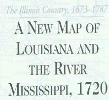
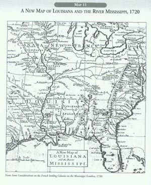
By 1720 the great dream of Jolliet, Marquette, La Salle, and other early explorers was taking shape. A French empire in the heart of North America, embracing both the Great Lakes and the Mississippi Valley, could be perceived on the map. French trading posts dotted the Great Lakes and were beginning to outline the Mississippi River. The Illinois Country thus became the hinge of a mid-continent empire, with Montreal on one wing and New Orleans, founded in 1718, on the other. With the rivers and lakes serving as the major arteries of communication and trade, the Indian nations of the interior would soon become firm allies of the French. To the English colonists along the Atlantic seaboard, this emerging view of North America posed a great threat. As early as 1720 a gentleman in America drew this map to show what was happening. It was the frontispiece for a pamphlet, Some Considerations on the French Settling Colonies on the Mississippi, published in London and concluding on a dire note for the English colonies in North America: "Some time or other, the Mississippi will drown our Settlements on the Main [land] of America" (page 45). But while "Illinois" is still spelled in the French style, English is today its native language. To explain why, teachers need to refer to one of the major narratives in American history: the Great War for Empire in North America that ended in 1763. This map is a good place to start. Reading the Map Students will be able to put this document into geographical context by comparing it with a modern map of the United States: The Great Lakes are at the top, the Gulf of Mexico is at the bottom, and the coverage extends from the Great Plains to the Atlantic Seaboard. The Mississippi River system (see Map 4) dominates the continent, pushing the ridge of the Appalachian (Apalatean) Mountains eastward on this map. This puts a cartographic squeeze on the English colonies along the Atlantic: Carolina, Virginia, Maryland, and Pennsylvania. Note how dotted lines indicate the boundaries of these colonies, ending at the mountain ridge.
The rest of the continent is marked off into four political entities: Florida, which belonged to Spain; the Iroquois Confederacy and its dependencies that encircled Lakes Erie and Ontario; Canada, or New France, which claimed the Great Lakes and upper Mississippi Valley; and Louisiana, which extended from the Gulf Coast to the lower Mississippi Valley. To read the map as its maker intended, envision all of the land west of the Appalachian ridge as united under the French crown. Even the Iroquois could be detached from English connections and allied with New France. As the Mississippi Valley, "a delightful Variety of Meadows and Groves . . . inhabited by almost two hundred different Nations" (page 20), was turned into a French colossus, English interests in North America would be put under great pressure. Working with the Map Coloring the map according to its political divisions will convince students of the point the anonymous gentleman was trying to make in 1720. Since it is an example of journalistic cartography, similar to maps that often appear in today's newspapers, students could be asked to write a news article or editorial for a London newspaper in 1720 expressing the concerns addressed on the map. A comparison of some geographic features with a modern map will show how the 1720 piece exaggerates some features to help make its point. For example, the Ohio River seems to reach directly into the heart of the Iroquois lands. Also note how one or two of the western branches of the Mississippi extended to a great lake in the northwest, perhaps an inlet of the South Sea (the Pacific Ocean) at about forty-five degrees of north latitude. Teaching the Map A focus on the Illinois Country will show its central location in the French vision of North American. Checagou, Ft. Louis (formerly called Crevecour), Lead Mines (Galena), the Illinois River, Lake Illinois, and "a rock of Crystal" (quartz or silica, the foundation of the state's later glass industry) are all labeled on the map. Students could highlight the current boundaries of Illinois and explain why these particular details appear on the map. 27
28
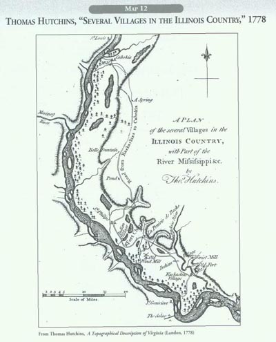
The claims on the Illinois Country by European powers started before the land was actually explored. In 1609 the English colony of Virginia received a charter that extended to the Pacific Ocean. The French and Spanish also advanced claims to this area, especially on their maps, well in advance of exploration or actual occupation and settlement. On various maps Illinois was envisioned as part of Spanish Florida, French Louisiana, or English Virginia. All three flags were unfurled at some time during the colonial period on Illinois soil. But in terms of actual settlement, only the French put down roots. In some places, these roots were deep enough to physically mark today's landscape with names, property lines, town plans, transportation arteries, and actual buildings. The major part of Illinois with this French heritage is the floodplain along the Mississippi River opposite the city of St. Louis. Thomas Hutchins was born in New Jersey in 1730. During the French and Indian War he became an officer in the regular British army. Skilled as an engineer and mapmaker, he drew the plans for Fort Pitt. After 1763 he took several expeditions to take stock of the lands newly occupied by the Redcoats between the Appalachians and the Mississippi River. He drew this map on site in about 1769 but did not publish it until 1778 when he was in London. It served as a frontispiece in his A Topographical Description of Virginia... that explained another map of eastern North America that he had drawn. This larger, separate map was printed in six large sheets. After refusing to fight against his native land in the War of American Independence, Hutchins was put into an English prison. Escaping to France and then to America, he eventually joined the patriot army a few months before Yorktown. After the war he served several states as an engineer, laying out new roads. In 1785, Congress appointed him Geographer of the United States. Reading the Map
This is a large-scale map, which means that the ratio between the distance on the ground and the measurement on the map is expressed in a large fraction, as far as maps go. In a large-scale map, individual objects, like the Mississippi River, appear large enough to show some details. The scale at the lower left indicates that one inch of the original map represented just over eight miles. Once readers grasp the level of detail possible in this type of presentation, they should move to a second type of representation, one suggested but not measured on the map, topography, or the lay of the land. The Mississippi River in this stretch between St. Louis on the north and the
29
Kaskaskia River on the south flows through a wide floodplain about eight miles wide. Steep bluffs on either side of the river define the flat land composed of rich alluvial soils. Note how backwater lakes and ponds dot this bottomland. The productive agriculture made possible by the combination of flat land, ample water, a mild climate, and productive soil made this area the heart of the French occupation of mid-America in the eighteenth century. When Thomas Hutchins initially sketched the map in 1769, French settlements on the east bank had come under the jurisdiction of Great Britain. St. Louis and St. Genevieve, across the river, were outposts of Spanish Louisiana. France gave up its great imperial claims in North America following defeat in the last phase of the Great War for Empire, which Americans called the French and Indian War. Thus Hutchins included this large-scale map of the center of the former New France at the beginning of his commentary on a very large, but small-scale, map of eastern North America. Working with the Map Students should work with the map in several ways to help them picture the bottomland as a functioning pioneer community. They might color the map to highlight various features or put sentences in boxes with arrows pointing to relevant locations, calling attention to various cultural elements like villages, mills, forts, roads, as well as natural features like woodlands, cliffs, ponds, and springs. A caption could make a summary statement about this multi-ethnic farming community, which contains the oldest European settlements in Illinois. Teaching the Map The detail possible on a large-scale map will help students grapple with a series of questions raised by the map. What was the purpose of the road from Cahokia to Kaskaskia? How long was it? What was the difference between the windmill and the waterpower mills? Why were both present in the community? Why were Indian and French villages located in the same area? Do you think many French settlers moved across the river to the new Spanish towns of St. Louis and St. Genevieve? The Illinois State Museum has published a full-color reproduction (at a reduced scale) of Thomas Hutchins' a large map of eastern North America, with the somewhat confusing title, "New Map of the Western Parts. . . ," in Sara Jones Tucker's atlas, Indian Villages of the Illinois Country (1942), plate XXIX. It is very interesting in its own right and could be used to locate the large-scale map of the Illinois Country.
From A Topographical Description of Virginia, Pennsylvania, Maryland, and North Carolina.. (London: J. Almon, 1778) A. "The high grounds .... [are] principally composed of Lime and Free Stone, and are from 100 to 130 feet high." p. 35 B. "The low land between the Hills and the Mississippi... has few trees, and is of a very rich soil, yielding shrubs and most fragrant flowers, which added to the number and extent of meadows and ponds dispersed thro' this charming valley, render it exceedingly beautiful and agreeable." p. 36. C. "Four miles above Cahokia, on the western, or Spanish side of the Mississippi, stands the village of St. Louis, on a high piece of ground. It is the most healthy and pleasurable situation of any known in this part of the country. Here the Spanish Commandant, and the principal Indian Traders reside; who by conciliating the affections of the natives, have drawn all the Indian trade of the Misouri—part of that of the Mississippi (northwards) and of the tribes of Indians residing near the Quisconsing [Wisconsin], and Illinois Rivers, to this village." pp. 38-39. D. "In short, everything, that a reasonable mind can desire, is to be found, or may, with little pains, be produced here." p. 45. 30
31 |
|
|