 |
Home | Search | Browse | About IPO | Staff | Links |
|
Home | Search | Browse | About IPO | Staff | Links |
|
Beginning at the mouth of the Missouri, you will take [careful] observations of latitude & longitude, at all remarkeable points on the river, & especially at the mouths of rivers, at rapids, at islands, & other places & objects distinguished by such natural marks & characters of a durable kind, as that they may with certainty be recognised hereafter. The courses of the river between these points of observation may be supplied by the compass the log-line & by time, corrected by the observations themselves. The variations of the compass too, in different places, should be noted.
The interesting points of the portage between the heads of the Missouri, & of the water offering the best communication with the Pacific ocean, should also be fixed by observation, & the course of that water to the ocean, in the same manner as that of the Missouri. Your observations are to be taken with great pains & accuracy, to be entered distinctly & intelligibly for others as well as yourself, to comprehend all the elements necessary, with the aid of the usual tables, to fix the latitude and longitude of the places at which they were taken...
Thomas Jefferson, Instructions to
In his instructions to Meriwether Lewis, President Thomas Jefferson was articulating one of the most-developed human traits, that
13
of territoriality. All organisms compete for resources such as sunlight, air, water, and food—and survival demands that they stake their claim to a portion of the earth's resource base and defend it. Humans and their institutions exhibit such a high degree of territorial behavior that just the threat of territorial competition is enough to cause conflict and, as a consequence, humans have necessarily developed incredible abilities to recognize, organize, and symbolize their territory with actual and mental maps. As a representative of both a human legal system and a human institution—the United States—Jefferson was conveying to Lewis the need to demarcate the territorial limits of what the president saw as American territory—territory that probably went, in his mind, far beyond the boundaries of the recently acquired Louisiana Territory. While Jefferson stated publicly that the Lewis and Clark Expedition was organized for "scientific purposes," and while the openly avowed objective of the Expedition was to locate a water route across the continent of North America for the purposes of commerce, more than anything else the objective of the Lewis and Clark Expedition was to claim territory and map it. Mapping is the human equivalent of an animal marking its territory by leaving scent, spoor, or other traces. Jefferson's instructions to fix the trading route to the Pacific by observation meant that Lewis and Clark should mark territory—measure and map it by making marks on paper, comparable to a bear making claw marks on trees. These marks would allow those who followed Lewis to understand new American territory by using concepts they could readily comprehend, just as bears immediately know when they encroach on one another's territory. For us to understand what the captains did in terms of mapping—recognizing, organizing, and symbolizing territory—and how they did it, it is necessary to establish some baselines and principal meridians of our own by examining the general nature of human mental mapping—the way that we visualize distance, direction, and time. HOW DO WE ALL GET AROUND? Human beings use two primary mechanisms of mental mapping—strategies that we all use every day to move from one place to another, to locate ourselves in reference to distance, direction, and time. The first, and most common, of these methods is based on recognition of real world landmarks; the second, and much rarer method is to abstract or imagine what the world looks like from high above the earth's surface—in other words, visualizing the world as if looking at a map. These two methods have not changed much for thousands of years and have never really relied on instruments other than the human senses. Obviously the needs of the Ice Age hunter in tracking, locating, and killing prey and then getting it back to the cave were different from those of today's shopper bound for the mall. But the two methods people use to recognize, organize, and symbolize familiar territory have basically been the same from the time of Pleistocene hunters to that of modern shoppers. The view from the ground: relying on landmarks Most people tend to imagine the world "horizontally," visualizing distance and direction from a ground-level perspective and locating themselves in terms of personal space—left, right, front and back, up or down. They give and understand directions in terms of landmarks that can be seen from the traditional vantage point of having both feet planted firmly on the ground. Their maps and mapping techniques tend to be concrete rather than abstract: the river, the hill, the woods, the cave, the filling station, the traffic light are the features that dominate both their mental maps and their real maps or pictographic representations of the world they might make for others. When the person with a horizontal perspective wishes to map a forested area, the favored technique will most likely be to draw a bunch 14
of tiny trees. In representing distance between the forest and the cave, or the filling station and the mall, travel time will be used as a surrogate for distance; the question "How far is it?" will be answered by "about twenty minutes." And in demonstrating the third dimension of terrain, hills and valleys will be drawn as "flat features in two-dimensional form [figure 1]. The view from above: seeing the world as a map A much smaller minority tends to imagine the world "vertically." They visualize distance and area in terms of the north-south (x) and east-west (y) coordinates of a two dimensional geographic grid system that they view from above. They give and understand directions in terms of the x-y reference points of the grid system. The world they carry around in their heads is the same world that they see on a conventional map. These people are able to interpret aerial photographs, satellite images, and conventional maps more easily than those who see horizontally. They readily convert direction concepts into latitude and longitude. They are better at abstract and symbolic mapping rather than picto-graphic mapping. The map-maker with this vertical perspective will show a forested area on a map by surrounding the area with a boundary and then filling it with a pattern or color that symbolizes "forest." Distance may be indicated by specific linear numerical units like miles or kilometers, and the map will be drawn at a defined scale in which distance is expressed in these linear units rather than time [figure 2]. And in showing
Figure 2. Sample of an x-y coordinate map. Redrawn from Arthur N. Strahler, Introduction to Physical Geography (John Wiley & Sons, 1970). 15
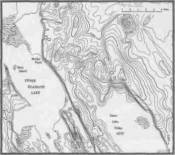
the third dimension or coordinate of elevation (z), the mapper with the vertical perspective will use symbols like hachures, contour lines, or color tints to indicate relief features [figure 3]. It is important to know here that the vertical perspective can be learned. Many extremely competent explorers, navigators, and others for whom an accurate sense of location-distance-direction was crucial, began as people dependent upon visual landmarks but learned how to use both instruments and their own senses to locate themselves and other places within the framework of the three-dimensional coordinate system of latitude and longitude and elevation. William Clark, who almost always knew where he was and was a superb maker of maps, was probably one of those people for whom the vertical view of the world came naturally. Clark's use of astronomical instruments to identify precisely his geographic location (latitude and longitude) was verifying what he already intuitively understood when he was in the field. In traveling across the landscape of the real world between the Mississippi and the Pacific, Clark constructed his mental maps before his actual maps. He looked both forward and backward, recognizing both sides of landmarks viewed from only one angle, and fitting everything into an imaginary grid system before ever putting it down on paper. Meriwether Lewis, no less intelligent and every bit as competent in the field, was just as likely among those people who see the world horizontally. He had to learn to convert his habitual perspective into a vertical one for purposes of navigation and mapmaking. For him, establishing position by instrument was revealing the natural world through scientific measurement. In the general known world of either the ancient hunter or today's shopper, both the horizontal and vertical forms of spatial understanding are sufficient. For Lewis and Clark, this was not the case because they were dealing with territory that was unknown and where conceptual problems arise with either the horizontal or vertical spatial perspective; they result from attempts to recognize, organize, and symbolize territory that is terrae incognitae. The person who tries to connect the known world with an unknown world has a great deal of difficulty in doing so because traditional methodologies for getting around do not work very well where landmarks are not known and cannot be seen, or where there are no primary reference points from which to obtain estimates of the dimensions of a geographic grid. For Lewis and Clark these difficulties of encountering the unknown lands and trying to map them was compounded by the fact they were also encountering people—or sources of spatial information—with different sets of spatial understanding than that of the American explorers. There were enormous differences between the Americans and the indigenous peoples of the West in terms of both experience and technology. Consequently, how the two peoples went about filling these blank spaces—and telling others about them—was also vastly different. Some of the most critical difficulties that Lewis and Clark had in mapping the unknown lands was trying to translate Indian spatial data into frames of reference that could be understood by American minds.
INDIAN SPATIAL CONCEPTS: The centuries-long encounter between the natives of North America and Europeans or Americans tells us that indigenous peoples were no different than people anywhere else in falling naturally into the two groups of horizontal and vertical viewers. Some Indian maps are really pictures of an area, drawn by people with a horizontal perspective, while others show evidence of having been drawn by those with a vertical perspective. But in spite of sharing the 16
horizontal-vertical perspective dichotomy with the American explorers, Indians differed greatly from Lewis and Clark in their manner of linking space and time, distance and direction. The reasons for these differences were primarily the result of the contrasting needs of the hunter-gatherer and subsistence farmer versus those of the commercial farmer, townsman, or tradesman with respect to time, distance, and direction. They were also the consequence of considerably different technology. Indian time Indians had little use for small elements of time such as seconds, minutes, or hours. The cyclical passage of the seasons, marked by the "moons" of the lunar calendar seems to have been a known feature of people for 35,000 years. The years, marked by the passage of "winters," the division of days and nights into "sleeps"—these were sufficient for people who did not have to get to work or worship or anywhere else "on time," and for whom, therefore, the small units of time were generally useless. Some native peoples in North America used a measure of time they called "a hand," meaning the amount of time it would take the sun to pass from one side to the other of a hand extended at arm's length toward the solar disk. But this measure was highly variable in a seasonal sense because of solar declination (the angle of the sun above the horizon) and in a personal sense as well in that individual hands were of widely varying sizes, and it was probably not widely adopted. Because the time-sense of the Indians they encountered was so vastly different from that of their own, Lewis and Clark had difficulty translating native descriptions of time. Indian distance Since the smallest unit of time with which Indians were normally comfortable was the solar day from one sunup to another, and since they possessed no long-range distance concepts such as miles or leagues, when asked for the distances between places Indians usually answered in terms of travel time, expressed as days or "sleeps." And generally, when Indians provided Lewis and Clark with time-distance-direction information, that information was shaped by the Indians' own experience. For example, the time it took to get from one known point such as the Hidatsa villages of central North Dakota to another known point such as the Great Falls of the Missouri depended on how the Indians made the trip. If they normally made the trip between the Mandan villages and the Great Falls as an all-male raiding party heading for the Rockies to steal horses from the Shoshones, the 600-mile distance between the two known points could have been expressed as "6 days." On the other hand, if they traveled from their villages to the Great Falls as part of a seasonal buffalo-hunting migration pattern, moving with entire villages—men, women, children, dogs, etc.—then the distance might have been defined as "20 days" or more. Lewis and Clark always translated the Indians' references to a "day's travel" into 25 miles of distance. Sometimes this worked, but more often it did not, and the captains made some wildly inaccurate distance estimates based on Indian information. Indian direction
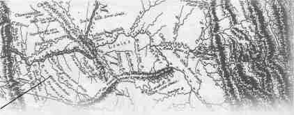
Indians generally expressed direction with reference to sunrise or sunset, again as modified by experience. When Indians told explorers that a path between two known points lay "to the left of the setting sun" this did not necessarily mean that the path ran northeast to southwest. Native movements in space—especially long-distance movements—were undertaken at certain specified times of the year. Therefore, when Indians gave directions with reference to sunset or sunrise, they understood those directions in terms of the sun's path in the sky at the times of the year when they took their journeys. But Lewis and Clark accepted Indian directional information as literal: "in the direction of the rising sun" meant "east;" "to the right of the setting sun" meant "northwest." For the Indian who lived near the mouth of the Knife River, north of today's Bismarck, North Dakota, on the 47th parallel, however, the location of sunrise or sunset varied throughout a 70 degree arc of latitude over the course of a year and, therefore, their "West" or "East" could be as much as 35 degrees north or south from the cardinal compass directions. These directional variations allowed significant errors to creep into the coordinate systems of explorers' maps and, because of the connection between directional error and distance, crucial distance errors appeared as well [figure 4]. For example, 17 William Clark, one of the best field cartographers in the history of exploration, used what was probably quite accurate geographical information provided by the Hidatsas at Fort Mandan to mislocate the Three Forks of the Missouri by about three hundred miles on the map of the West that he drew during the winter of 1804-1805 at Fort Mandan. FORMAL NAVIGATION AND LEWIS & CLARK
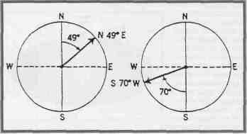
Did these difficulties of translating Indian distance/direction information into a spatial frame of reference understandable to Americans mean that all geographical information obtained from Indians was useless? Not at all—it just meant that the captains had to learn to match up Indian information with data obtained through their field observations. They did part of this through what we call today "ground truthing"—checking Indian data against their own visual observations. They also relied on "celestial reckoning," using the instruments they carried for the purpose of fulfilling Jefferson's instructions to "take [careful] observations of latitude & longitude." To fulfill these tasks they used instruments: spirit and telescopic levels; several compasses, including a surveyor's compass or circumferentor with extra needles and even a magnet to "polarize" them; a sextant, a "Hadley's quadrant" or octant, rods and chains, telescopes, artificial horizons, drafting instruments, a very early version of a measuring tape, and a clock or chronometer. They also used books and tables giving the daily locations of sun, moon, and planets for use in computing geographical position after obtaining sightings of these "celestial objects." The two most important groups of items of the Lewis and Clark Expedition, if cost is the measure, were mapping instruments and gifts for native peoples: these were the tools of empire, necessary in establishing a claim to place and space and defending that claim through trade. An entire issue of We Proceeded On, the quarterly journal of the Lewis and Clark Trail Heritage Foundation, has been devoted to the mechanics of the celestial navigation of the Expedition, and it is not the intention here to replicate what that excellent issue has produced. Rather, the objective in the concluding section of this essay is to discuss the general philosophy—the epistemology—of how Lewis and Clark knew what they knew about spatial data based on their own "reckonings." Both Lewis and Clark were reasonably proficient in the use of the instruments they carried with them, and for twenty-eight months—as long as the expedition was on the move—a part of the daily routine was the measurement of latitude and longitude and the calculation of course, time, and distance of travel. Even during those times when Lewis and Clark were fixed in location for lengthy periods of time, such as the winters spent at Fort Mandan and Fort Clatsop, the "mathematical instruments" saw almost daily use, weather permitting. In this, the captains followed Jefferson's instructions to the letter and throughout the course of their journey made the two basic types of geographical observations their sponsor had requested: (1) daily measurements of local features, taken continually during a day's travel; and (2) the more abstract measurements of latitude and longitudinal position, usually made by astronomical observation when and where atmospheric conditions allowed, but most commonly at camp during the night. Those Cryptic Journal Entries: Course... Time... Distance... Remaks. & refurncs By far the most common observations were the daily measurements that are found in the journals of Lewis and Clark as "Course...Time...Distance.-.. Remaks-. & refurncs-." These were carried out primarily by Clark, with both his vertical perspective and his Army experience in field mapping—the use of compass, log lines, and close estimating of distances. Course referred to the direction the expedition was traveling, stated as a compass bearing between two points. To obtain this bearing or "azimuth" [figure 5], the captains used one 18
of the pocket compasses or else the larger surveyor's compass or "circumferentor" to get direction from one reference point to another—from the point of a bluff along the Missouri's north side, for example, to the tip of a prominent sandbar on the south side of the river. Naturally, their compasses registered magnetic north rather than geographic north, and their readings had to be adjusted for the difference or "declination." That magnetic and geographic north were not the same had been known since the fifteenth century and maps of "isogonic" lines showing compass variations from east to west had been drawn as early as the mid-1600s. Lewis and Clark understood very well the errors that would creep in as they moved across the continent, and so continually adjusted the declination of their compasses to insure accuracy of readings. In fact, one of the things that Jefferson had instructed Lewis to do was to keep track of "variations of the compass too, in different places." Time, stated in hours and minutes, was the time required to get from the reference point used to establish the beginning of a course azimuth to the reference point marking the end of that particular compass bearing. Time was established precisely by chronometer—as long as the captains remembered to keep it wound. Because they did forget to wind it regularly, there were frequent occasions when travel time was an estimate. But living as close as they did to the natural world, while still having a temporal frame of reference that included hours and minutes and seconds, reasonably accurate time estimates would have been less of a problem for them than for the native peoples who possessed little or no short-term time concepts. Still—most of the temporal observations of Lewis and Clark were obtained by timepiece—a chronometer that cost more than all the rest of their "mathematical instruments" combined. Distance was expressed between the same two points used to derive course and time. This was normally given in miles but occasionally in yards or rods. These measurements were obtained either by pacing a course between two points or by estimating distances. Estimations are relatively easy for people having long familiarity with their environment, their own travel paces, and their mode of transport. They walked about as often as they rode, and this allowed them to judge both time and distances much more accurately than we can while driving a car at speeds that may vary as widely as 15 miles per hour in a school zone to 75 on an interstate highway. The captains' sense of time and distance was more precise than ours because their survival so often depended on it and because they moved across the landscape in very different ways than we do. Throughout the expedition, the captains were reasonably accurate in their measurement of distance. They accomplished this with good guesswork, with enlisted men performing the grunt work of pacing out courses, and with fairly sophisticated instruments and mathematical calculations and careful attention to detail. Remarks or reference observations were comments on the widths of the Missouri and the creeks and smaller rivers that entered it, the heights of bluffs or hills along the river, and—most common and most important—the identification of the reference points upon which the compass bearing/distance/direction information was based. Jefferson's directive to Lewis had included the order to note "all remarkeable points on the river, & especially at the mouths of rivers, at rapids, at islands, & other places & objects distinguished by such natural marks & characters of a durable kind, as that they may with certainty be recognised hereafter," and the captains were faithful to those instructions. . . . you will take [careful] observations of latitude & longitude Thomas Jefferson was as interested in the methods and equipment for "ascertaining by celestial observation the geography of the country" as with any other single aspect of the Expedition. He played an important role in making sure that Lewis purchased the proper equipment and learned how to use it before he left for the West. He also insisted that observations be conducted with accuracy, would be redundant, would be comprehensible to others, and that sufficient copies of all observations would be made to guarantee against the possible loss of one or more sets. As faithfully as they could, the captains complied with the president's wishes. It fell to Lewis, with his horizontal perspective, his penchant for detail, and the training in astronomical observation he had received in Philadelphia during the planning stages for the Expedition, to handle most of the astronomical observations. Latitude. For Lewis and Clark, as for so many of their predecessors and contemporaries, calculating latitude was far simpler than calculating longitude. In the northern hemisphere, latitude may be derived from measur- 19
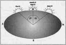
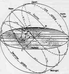
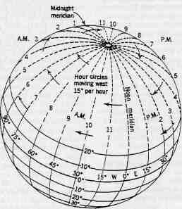
ing the angle made between the North Star and the horizon. Crude instruments to obtain this angle have existed for thousands of years, and by the time of Lewis and Clark, instruments like the sextant and octant, only slightly less precise than those available to us, were in use. Latitude may also be calculated by measuring the altitude of the sun, moon, or certain planets and stars above the horizon on known days and reading latitude from tables designed for that purpose. It was not difficult for the captains to measure these altitudes with a sextant or octant and to calculate latitude using one of the three ephemerae or astronomical almanacs they carried. These contained tables showing the daily position of celestial bodies such as the sun, the moon, and key stars. Calculating latitude gave Lewis and Clark few problems, and their readings, usually made of the noon sun's elevation above the horizon, were accurate to within a fraction of a degree [figure 6]. Longitude. Longitude can be calculated using either time or astronomical observation. Calculating longitude by chronometer is based on the fact that any point on the earth's surface moves through a complete circle of 360° once in a 24-hour period; during one hour, any point on the earth's surface moves through an east-to-west 15° arc of a full circle. If time can be fixed along any meridian of longitude, then longitudinal distance can be determined by comparing time at that meridian (what is known as "mean time") with local time, usually based on the point at which the sun reaches its zenith [figure 7]. It has been conventional historical wisdom that the longitudinal readings obtained by Lewis were prone to significant error and that Ferdinand Hassler—probably the country's most brilliant mathematician—could not make sense of Lewis's astronomical observations after they had been provided him after the Expedition's successful return. It now appears
20
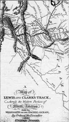
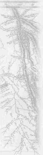
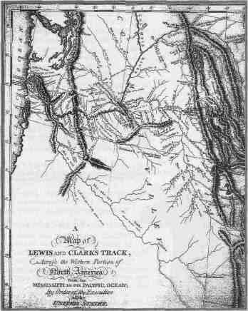
that the fault lay mainly with Hassler and not with Lewis, whose observations of longitude were, given the field conditions and the relatively primitive equipment with which he had to work, quite accurate. To the extent that error crept in, it was largely the fault of their chronometer, which did not have, as ours do, a quartz battery to keep it running. When it ran down, it had to be recalibrated using local time—using observation of the sun's zenith or local "noon" and then setting the chronometer by estimating the Expedition's current longitudinal position. Over the course of the expedition, the small incremental errors produced by this became larger ones—but in no case was Lewis off in his longitudinal reckoning by as much as a degree of longitude. There were other methods of calculating longitude available to them, through astronomical observation. At Fort Mandan, for example, Lewis calculated longitude by timing a fortuitous lunar eclipse on January 14, 1805. But many astronomical readings had to be acquired over the course of a night in order to obtain sufficiently precise data to determine longitude. It was asking a lot for men exhausted by the rigors of their daily trek to spend three or four hours in the cold and damp of a mountain night taking sightings of the moon and stars, recording observations, and making calculations by firelight. It was only natural that errors would exist in data obtained in this manner. Even the most skilled astronomer or surveyor would have been hard pressed to make highly accurate observations under such circumstances. .. that they may with certainty be recognised hereafter After the Expedition Jefferson noted that "it is only to latitudes that [their] map may be considered as tolerably correct, not as to its longitudes." This was overly critical and has quite probably been the primary source for the long-standing contention that the captains' longitude observations were less than perfect. Yet William Clark's ultimate map of the western portion of North America, based in part on those observations, nevertheless proved quite accurate in its longitudinal reckoning. In the final analysis, in spite of the extant errors, their longitudinal observations were better than could or should have been expected. The ultimate results of their "observations of latitude & longitude" bore that out. Clark's final map [figure 8] was the culminating piece of geographical information emerging from the expedition and resulting directly from Jefferson's injunction to preserve knowledge for the future. Completed in manuscript form by 1811, engraved and published with the Biddle History of the expedition... in 1814, it portrayed with artistry, skill, and accuracy the area through which the expedition had passed. Course and distance information is apparent on that map, and coordinate positions are accurate to within five percent, an accuracy level that would not be matched by many cartographers until the advent of mapping aided by aerial photography in the early-twentieth century. The errors inherent in earlier Clark maps, errors that resulted largely from his and Lewis's difficulty in translating Indian information into their own frame of reference, were mostly gone—and where errors were present, they were confined to areas the expedition had not traversed. For the area visualized—both horizontally and vertically—during the period from May 1804 and September 1806, Clark's final cartographic 21
product was remarkably precise. This master map of the American West represented the ultimate blending of Lewis's astronomical observations and Clark's vertical perspective, his ability to synthesize mental and actual maps and to portray geographical features with precision in the context of the geographic coordinate system within which he operated. That map, like the other geographical results of the expedition, set the standard for other explorers to follow, and although America's first great territorial mapping project did not achieve all the scientific precision the president had wished for, it was enough. The mental maps had become actual maps and an American claim over territory from the Mississippi to the Pacific was secured.
22 |
|
|