|
Home | Search | Browse | About IPO | Staff | Links |
|
Home | Search | Browse | About IPO | Staff | Links |
|
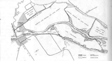
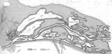
By PETER FRIEDERICI Science and state government since 1851: the case of the Illinois River Near Stephen Havera's office in Havana, on the Illinois River 40 miles downstream of Peoria, Quiver Lake is drying up. Ninety years ago it was a sandy-shored body of clear water, rich with aquatic vegetation, a fertile spawning ground for fish and feeding area for ducks. And this, says Havera, is Quiver Lake today: "It's 85 percent filled with sediment. Only 15 to 20 percent of the surface water remains. The rest is mudflats colonized by willow trees. The open water is a few inches to two feet deep during low-water periods. And the aquatic vegetation is pretty much gone. The lake's life is only a remnant of what it once was." When Havera looks over the mudflats he looks back in time, too. He is the director of the Illinois Natural History Survey's Forbes Biological Station, the field headquarters from which hydrologists, botanists and other scientists have been monitoring the health of the Illinois River for years. When the station was founded in 1894 the river ran through one of the most productive ecosystems in the nation. It was fringed with hundreds of backwater lakes and surrounded by rich woodlands. Mussels, fish and birds abounded. In 1910 2,600 mussel boats plied the Illinois, along with several thousand fishing boats. Station scientists measured the retreat of aquatic life from the flow of raw sewage after Chicago opened its Sanitary and Ship Canal in 1900. They noted that fish and other organisms recovered somewhat after sewage treatment plants were built. By the 1950s they noticed a more serious problem. The backwater lakes were filling up. Loose silt was deposited in the lakes during the high water of spring. The silt buried aquatic plants and was so loose that new shoots could not take root. Lacking shelter, fish populations declined; lacking food, ducks vanished. The backwater lakes had always served as a natural flood-control mechanism, filling up with water in spring and slowly releasing it in summer. Now, with the lakes partly filled in and with many wetlands diked off from the river and turned into farmland floods became more devastating. By plotting the accumulation of sediment against the great increase in row-crop farming that followed World War II, researchers figured out that the silt was washing off fields. Many farmers had begun plowing fields in the fall, leaving bare soil exposed all winter. It blew away or washed into creeks and ended up in the river. Most agricultural lands in the Illinois watershed have lost between two and nine inches of topsoil in the last century; over large areas less than half of the original topsoil 22/May 1992/Illinois Issues
remains. The Illinois is a slow-flowing river, unable to bear away much sediment. So it piled up at the margins, in the lakes. By 1982 it was estimated that 15 million tons of new sediment were ending up in the river system every year. In a 1983 report, Natural History Survey researchers predicted that many river lakes would soon retain "little biological or recreational value." The fishing and musseling industries have declined drastically. Recreational fishing and boating opportunities have been diminished. Waterfowl populations are way down. The nine-foot-deep channel that the Army Corps of Engineers keeps open for barge traffic is narrowing in some areas; the Corps spends about $1 million a year dredging it open, but estimates that it would cost over $325 million a year to transport materials now shipped by barge via other carriers. Erosion is a natural process, but at this vastly accelerated rate it is tragic. Every bushel of topsoil that washes away represents the loss of the accumulated natural wealth of centuries. It is all the more tragic because it has been so well documented by scientists who have been watching for so long and yet have been able to do so little about it. When white settlers reached Illinois they found a wealth of natural resources minerals, soils, fish, wildlife that they set out to use. In 1851 state legislators decided that minerals could be more efficiently exploited if a geological survey were conducted to determine what lay where. They named J.G. Norwood as Illinois state geologist. Legislators wanted useful maps of lead and coal deposits. Norwood wanted to collect rock and fossil specimens and create a theoretical framework that could explain why those deposits lay where they did. After a few years, he was fired. The juxtaposition of "pure" long-term research with short-term practical goals has bedeviled survey scientists ever since. In the 1850s, Illinoisans were also becoming increasingly interested in progressive agriculture. How could harmful insects be controlled? How could crop yields be increased? In 1858 a group of laymen established the Illinois Natural History Society at Bloomington. A few years later they began a comprehensive study of the state. "Resolved," they wrote, "that a natural history survey of the State, in all the departments of Natural History, for the purpose of securing a more general knowledge of its agricultural and mineral resources, is a matter of vital importance to the people of Illinois, and worthy [of] legislative action in furnishing means to do it economically and successfully."
It took a few more years before any state money was granted, but by 1877 state appropriations for science were becoming regular. Stephen Forbes was hired to direct what was by then being called the Illinois State Laboratory of Natural History, which he promptly moved to Champaign. His task: survey the plant and animal life of the state, and figure out how to lessen insect depredations on crops. But his vision, and his work, went beyond collecting, labeling and classifying. Forbes was a polymath whose wide range of interests and deep understanding of natural systems led some observers to call him the father of modern ecology. His 1887 paper "The Lake as Microcosm" showed an advanced understanding of the interrelation of the plant and animal life of a small lake. Forbes was driven by that holistic approach when he established the Havana station in 1894. How, he wondered, did the elements of a river ecosystem interact, and how did they change over time? That summer four scientists began collecting plants, animals and water samples. One of the early researchers was Charles Kofoid, a plankton expert who wrote of the area's "exceedingly abundant vegetation, indeed almost tropic in its luxuriance. ... [To a visitor] the gigantic growths of the semiaquatic Polygonums will furnish evidence of the fertility of their environment." By the time Kofoid published a thick report on river plankton in 1903 the modern scientific surveys were pretty well established. Concerns about the safety of water supplies had led to the creation of a state Water Survey in 1895. In 1905 the state Geological Survey was organized, just as oil and gas exploration accelerated. In 1917 Forbes's team was combined with the state entomology May 1992/lllinois Issues/23
office to form the Natural History Survey, and the three surveys were put into the new Department of Registration and Education, a sort of catch-all agency that largely let survey directors do whatever they wanted. Under this benevolent neglect, and under the strong leadership of several directors who were in office for decades (including Forbes, who died in 1930, having headed the Natural History Survey for over 50 years), the surveys thrived. Biologists produced catalogs of Illinois plants and animals. Geologists compiled maps of coal deposits and tried to figure out how to burn it more cleanly. Chemists analyzed contaminants in municipal and private water supplies. Survey scientists published reams of papers in respected professional journals. Their data has generally been regarded as unimpeachable, perhaps partly because the surveys have never been given any regulatory function. Survey scientists have poked, prodded, measured and tested every corner of Illinois. And it is the depth and breadth of this research, according to Natural History Survey Chief Lorin Nevling, that enables scientists to react quickly to new problems. "On past experience, we know there's going to be a new challenge every year," he says, citing the spread of zebra mussels that now threatens to clog water intakes and supplant native species throughout the Great Lakes and inland waterways. "We don't have any low priorities because we don't know where the next problem is going to come from. In this case we had a couple of people who had worked with other mussels before, so they were able to shift gears pretty rapidly and start studying the zebra mussels."
Havera calls the data set gathered on the Illinois River "irreplaceable." Survey scientists have access to decades of data. Measurements of lake-bottom profiles made today can be compared with 1903 measurements made long before anyone realized sedimentation would become a problem. Only from data collected over time have researchers been able to figure out how sediments move, where they are deposited most readily, whether they have toxic components, and what the damages to plant and animal life are. But scientific understanding is only one aspect of the surveys' work. Havera hopes the Illinois River research will help control sedimentation, partly by promoting soil conservation and not just in Illinois. "We feel that the upper Mississippi River is about 30 or 40 years behind the Illinois," he says. "So a lot of what we do here has national and international implications." Perhaps the Illinois can serve as a cautionary example of later stages of erosion. 24/May 1992/Illinois Issues It's also possible that researchers may be able to help ameliorate the situation they've studied. The Water Survey's Don Roseboom and Robert Frazee of the University of Illinois extension service have been piloting a streambank-stabilization program along tributaries of the Illinois. Water Survey research showed that a surprising quantity of river sediment up to 45 percent, says Frazee comes from eroding streambanks. The two scientists tried planting trees on unprotected banks, and they found that this technique is more effective and far cheaper than using rocks or concrete. Now Frazee is using the extension service's extensive education network to "download" the research results to farmers and soil-conservation agents throughout the Midwest. "I was not aware of the great depth and value of the Water Survey's research until I started using it," he says. Other Water Survey programs have experimented with revegetating lakes by creating artificial reefs and reintroducing aquatic plants. Frazee says the top priority in controlling sedimentation is reducing erosion from upland areas. The 1980s saw a dramatic increase in unfilled farm acreage; that has helped, he says, but much remains to be done.
The backwater lakes of the Illinois once covered such a large area that there is no way to dredge them all out. But some areas can be reclaimed if the will and the money are there. Havera wants to make a national wildlife refuge of Thompson Lake, a large pool near Havana that was drained for agriculture in the 1920s. The levee separating it from the river would remain, and would help keep sediment out. But what are now fields would be flooded, and the data that Charles Kofoid collected around the turn of the century would help biologists figure out what they want the lake to look like. "Many lands would be more productive as wetlands than they are when you're constantly pumping out water to drain fields," says Havera. "And the data on Thompson Lake that goes back to the 1890s can tell us what it could be like if we did restore it." The Illinois River is never again going to look the way it did when Kofoid was collecting plankton at least not anytime soon but his research might still help the waterway become a richer and more diverse place than it is now. Peter Friederici is a Chicago-based free-lance writer specializing in natural history and environmental issues. He has written several articles about the Illinois River area for the Chicago Reader. May 1992/Illinois Issues/25 |
|
|